Super Week for our Doctors 2023!

This week has been special for the Digital Geography Lab and our Doctors 2023 group! The faculty councils of the Faculty of Science and Faculty of Biosciences did the following official decisions:

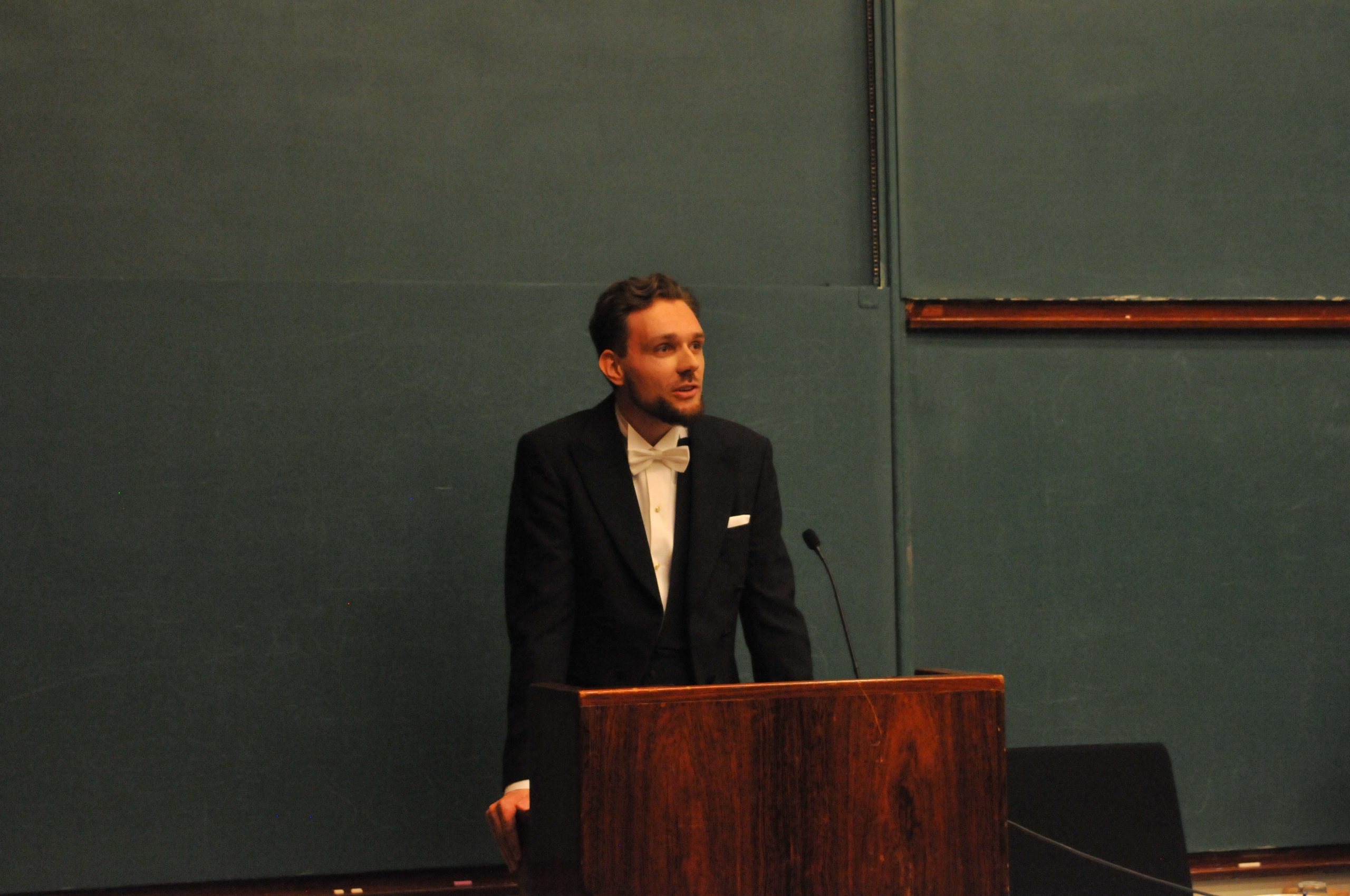
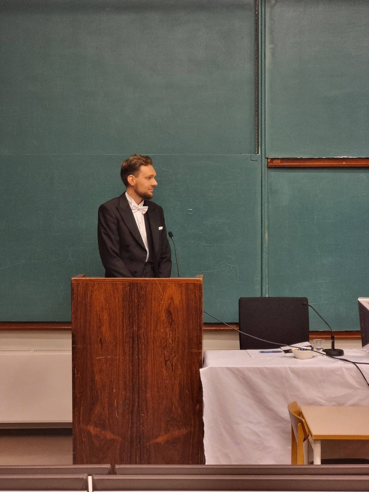
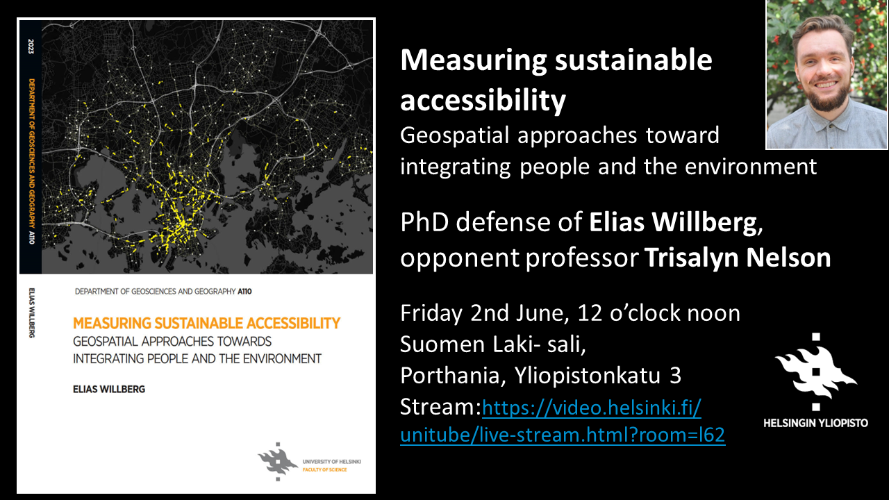
🌟 Elias‘s thesis Measuring sustainable accessibility: Geospatial approaches toward integrating people and the environment was accepted with honors! Elias defended on the 2nd of June 2023 with Trisalyn Nelson, Jack and Laura Dangermond Endowed Chair of Geography, University of California Santa Barbara, as the opponent.

🌟 Aina got permission to advance to the public defense with her thesis Shaking Environmental Education Paradigms. Practitioners’ narratives, contextual elements, and biocultural approaches. The public examination will take place on 20th September 2023, at 10 in Porthania (Yliopistonkatu 3), lecture room P674 or online. Senior Research Fellow Sarobidy Rakotonarivo, Department of Forestry and Environment, University of Antananarivo, Madagascar will act as the opponent. Aina did her PhD in the Global Change and Conservation research group.

🌟 Tuomas got permission to defend publicly his thesis Diversity of places and people: Using big data to understand languages and activities across geographical space. The public examination will take place on 10th November 2023.  Grant McKenzie, Associate professor of spatial data science in the Department of Geography at McGill University, will act as the opponent.

🌟 Kerli thesis Capturing segregation through space and time: New insights from the activity space approach and big data was sent for pre-examination. The tentative defense date is 24th November 2023!

Hooray & hugs to #Doctors2023🥳🤗

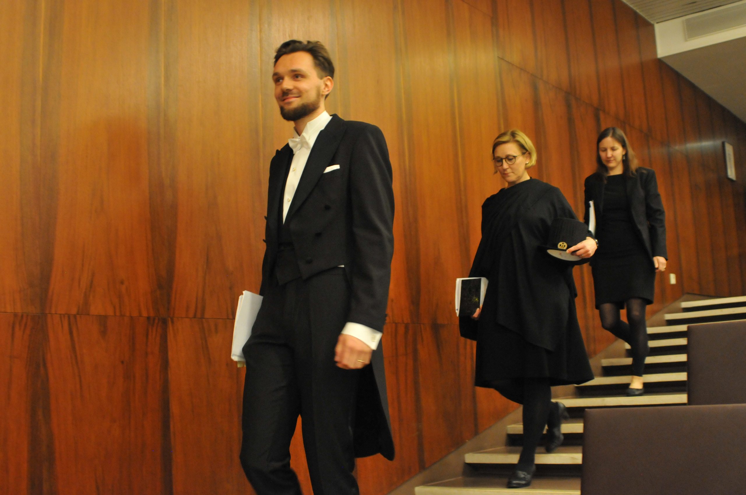
Elias heading to defend his thesis on the 2nd of June. Tuuli as custos and Trisalyn as the opponent follow. Photo by Christoph Fink.

– – – – –

The Digital Geography Lab is an interdisciplinary research team focusing on spatial Big Data analytics for fair and sustainable societies at the University of Helsinki.

Contributing to the development of Geography Master’s degree curriculum

The Digital Geography Lab has been participating actively in the curricula development of the Geography MSc and BSc Programmes. During 2020-2022 Tuuli acted as the Director of the Geography Degree Programmes.

Therefore it makes sense to share an article covering the renewal process of the Geography MSc degree programme structure in the Digital Geography Lab blog. The article has been translated from the original publication in Finnish:

Toivonen, T., Kainulainen, H. T., Kosonen, K., & Ruth, O. (2023). Havaintoja maantieteen maisteriohjelman uudistamisprosessista. Terra, 135(2), 98-105. [https://terra.journal.fi/article/view/130170/80100]

Observations on the reform process of the Master’s Curriculum in Geography

In this article, we describe the process aimed at reforming the curriculum of the Master’s Programme in Geography at the University of Helsinki. The reform process was carried out during the years 2021–2022 and it was coordinated jointly by the Degree Programme Director, Deputy Director, Education Planner and one dedicated university teacher. The impetus for documenting the process in the form of this article came from the leadership studies by Professor Tuuli Toivonen. Toivonen served as Degree Programme Director and Olli Ruth as Deputy Director during the reform. The roles changed in summer 2022. Coinciding with this change, the processes moved from planning the structure of the curriculum to planning the implementation of courses.

Background of the curriculum reform

Teaching at the university is defined by the curricula of study programs. Typically, the curricula define the general degree structure and study tracks, as well as the learning outcomes, contents, scopes and competence assessment methods of study modules and courses – as well as the teachers responsible for the courses.

The curricula of the University of Helsinki have been in transition during the past 20 years. In the turn of the Millenia, European countries started the so-called Bologna process that aimed at harmonising the university degrees in Europe. This led to degree reforms at the University of Helsinki first in 2005 to be continued in the mid-2010s. The aim of these reforms was to make the bachelor’s and master’s degrees clearly separate, thus improving students’ opportunities to move from one degree programme to another between these study stages. In addition, efforts were made to strengthen the link between studies and working life. In the next phase, in 2017, the University of Helsinki implemented a reform called the Big Wheel, which introduced new system of three-year curricula. The old majors were replaced by degree programmes and minor subjects by elective study modules. The first curriculum period of the reform was 2017–2020 and the second 2020–2023.

Continue reading “Contributing to the development of Geography Master’s degree curriculum”

New article out! Measuring just accessibility within planetary boundaries

Our new article Measuring just accessibility within planetary boundaries has been published in Transportation Reviews! The paper was the led by Elias Willberg and it was the last paper of his PhD to be published. The paper suggests that we should measure and evaluate accessibility in a more comprehensive way, expanding from time-based measures to measures that take into account the environmental costs and impacts on social justice.  The paper was a fantastic collaboration between Digital Geography Lab and Henrikki Tenkanen (Aalto University), Rafael Pereira (Institute for Applied Economic Research, Brazil) and Harvey Miller (Ohio State University).

Please find the press release below!

Press Release: Doughnut thinking supports sustainable mobility planning

Transport and mobility produce a significant part of cities’ carbon emissions and other environmental burdens, but at the same time enable the satisfaction of many basic needs, from going to work to meeting friends.

The scientific article, carried out in collaboration between Finnish and international researchers, shows how the doughnut model, which examines the overall sustainability of societies, can be applied to transport. The study published in Transport Reviews was led by Finnish researchers from the Digital Geography Lab of the University of Helsinki and Aalto University.

“The central idea of the doughnut model developed by the economist Kate Raworth is to provide the basic conditions for a good life for everyone without exceeding the critical boundaries of the environment,” says postdoctoral researcher Elias Willberg from the Department of Geography, who led the research. “We propose that this idea should also be applied in the transport sector, where reducing emissions has long been difficult. You only have to look at the current extreme weather around the world to notice that there is a great and urgent need for a change in ways of thinking and acting,” he continues.

Continue reading “New article out! Measuring just accessibility within planetary boundaries”

Elias’ Lectio Praecursoria

Measuring sustainable accessibility: geospatial approaches toward integrating people and the environment

Lectio Praecursoria in the public examination of Elias Willberg doctoral dissertation on 2nd June 2023

Photo by Christoph Fink

Sustainability means meeting the needs of the present without compromising the ability of future generations to meet their own needs.

Currently, we are compromising that ability. We have exceeded several planetary boundaries, which mark the safe limits for humanity. We are consuming environmental resources at a rate, which would require several planets to sustain. And we, are still on a path where our environmental burden continues to increase.

At the same time, our social challenges remain persistent. In a world of overconsumption, no country has been able to meet the basic social needs of its citizens at a sustainable level of resource use. Inequalities between people are increasing again and growing environmental stresses, like climate change and biodiversity loss only make it harder to achieve social goals.

What we ultimately want, is to reach that safe and just space in the middle, between the ecological ceiling and social foundation where we don’t consume more than what we have, but where we also leave no one behind. Guaranteeing a good life for everyone, without compromising the planet, represents the ultimate goal for our societies.

Continue reading “Elias’ Lectio Praecursoria”

Elias Willberg successfully defended his PhD thesis – Trisalyn Nelson as opponent

Elias Willberg successfully defended his PhD thesis last Friday!

The defence took place on Friday, 2nd June 2023, with Professor Trisalyn Nelson from the University of California, Santa Barbara as the opponent. The defence started with Elias Lectio Praecursoria, and continued with a lively discussion with the opponent about Elias’ thesis

See Elias’ thesis here: ”Measuring sustainable accessibility : geospatial approaches toward integrating people and the environment”. Elias’ work was supervised by Prof Tuuli Toivonen, Prof Henrikki Tenkanen and Prof Age Poom and funded by the Amer Cultural Foundation (Sporttia Stadiin) and EU (URBANAGE and HOPE projects).

On the week before the defence, we had the honour of hosting the opponent, Professor Trisalyn Nelson, at the University of Helsinki. She gave an exciting talk for a broad audience on-site and online, with the title “Crowdsourced Data for Active Transportation Planning“.

The busy days culminated in the cheerful Karonkka party on Saturday evening, with a long and bright summer evening. On Monday, Elias switched to a new life chapter by starting a three-month paternity leave with their small daughter.

Hooray & hugs to Elias! 🥳🤗

Many thanks also to the opponent, Prof Trisalyn Nelson, for visiting us and leading the discussion with academic expertise and curiosity, in a cheerful spirit! 🤗

Continue reading “Elias Willberg successfully defended his PhD thesis – Trisalyn Nelson as opponent”

New Travel Time Matrix 2023 and GREENTRAVEL project

Digital Geography Lab presented a new travel time matrix 2023 and a new big project GREENTRAVEL in a seminar held in Think Corner.

Helsinki region travel time matrix was published now for the fourth time. The matrix is an interactive open access dataset that allows investigation of travel times for different travel modes in Helsinki region. Professor Tuuli Toivonen gave an insight to the history of the matrix which was first published already ten years ago in 2013.

Since the first matrix was computed, the technology has improved and enabled the use of new methods. Christoph Fink explained how the new matrix was calculated and showed how it works.  Current accessibility prospects and changes in the regional structures of accessibility in Helsinki region were described by Elias Willberg. We also had two guest speekers, Miikka Haimila and Iiris Karvinen, from the city of Helsinki. Haimila reflected the importance of matrix for the city and its open data activities. Karvinen took the angle of a planner and demonstrated how the matrix has been serving the planning needs of the city.

In the end Tuuli Toivonen presented our new big project GREENTRAVEL which aims to explore the availability and quality of green urban travel environments and their impacts on wellbeing through the prism of urban informatics. We continued the discussions right after the seminar in a GREENTRAVEL workshop where we focused on the role of greenery in urban travel environments and how greenery can be better incorporated in current green infrastructure and travel and mobility planning.

Continue reading “New Travel Time Matrix 2023 and GREENTRAVEL project”

Uusi matka-aikamatriisi 2023 ja GREENTRAVEL-projekti (available in English as separate post)

Digital Geography Lab esitteli uuden pääkaupunkiseudun matka-aika-aineiston 2023 ja juuri käynnistyneen GREENTRAVEL-tutkimushankkeen Tidekulmassa järjestetyssä julkaisutapahtumassa.

Pääkaupunkiseudun matka-aikamatriisi julkaistiin nyt jo neljättä kertaa. Matriisi on avoin paikkatietoaineisto, joka mahdollistaa matka-aikojen vertailun eri kulkutavoilla pääkaupunkiseudulla. Professori Tuuli Toivonen kertoi matriisin historiaa valaisseessa puheenvuorossaan ensimmäisen matriisin julkaisusta kuluneen jo 10 vuotta.

Teknologian kehittyminen ensimmäisten matriisien tuottamisen jälkeen on mahdollistanut uusien menetelmien käytön laskennassa. Christoph Fink esitteli miten uusi matriisi on laskettu ja miten se toimii. Elias Willberg valotti pääkaupunkiseudun nykyistä saavutettavuusmaisemaa sekä muutoksia saavutettavuuden alueellisissa rakenteissa kuluneiden 10 vuoden aikana. Mukana olivat myös vierailevat puhujamme Miikka Haimila ja Iiris Karvinen Helsingin kaupungilta. Haimila kertoi matriisin merkityksestä kaupungille ja sen avoimen datan toiminnalle. Karvinen osoitti suunnittelijan näkökulmasta miten matriisi on palvellut kaupungin suunnittelutarpeita.

Lopuksi Tuuli Toivonen esitteli uuden viisivuotisen GREENTRAVEL-tutkimushankkeen, jossa selvitetään liikkumisympäristöjen laatuun ja vihreyteen liittyviä mieltymyksiä sekä niihin kytkeytyviä hyvinvointivaikutuksia ja näiden alueellista, vuodenaikaista ja yhdenvertaista saatavuutta. Jatkoimme keskustelua aiheesta seminaarin jälkeen pidetyssä GREENTRAVEL-työpajassa, jossa keskityimme vehreyden rooliin kaupunkien liikkumisympäristöissä sekä tapoihin tuoda vehreys näkyvämmin osaksi liikkumisympäristöjen suunnittelua.

Continue reading “Uusi matka-aikamatriisi 2023 ja GREENTRAVEL-projekti (available in English as separate post)”

The case for the societal benefit of user-generated big data research – DGL responds to EU on research data access

Authors: Tatu Leppämäki, Tuuli Toivonen, Olle Järv together with other Digital Geography Lab members

The Digital Services Act (DSA) is legislation by the European Union that aims at protecting the users of and mitigating risks caused by online platforms, covering anything from social media sites to search engines and online retailers. It does this by obligating the platforms to, for example, be transparent about content recommendation systems, and effectively tackling content manipulation and spreading of disinformation. Due to their significant effect on our societies, the legislation sets more obligations for very large online platforms (VLOP): this class of platforms include social media giants, such as Facebook, Youtube, Instagram, Twitter, and Tiktok.

As a research group that has successfully applied user-generated data to study multitude of topics, our interest in the legislation stems from its sections that obligate VLOPs to give means to access data uploaded on their platform for appropriate research purposes (Article 40 of the act). While these purposes are limited for scrutinizing the systemic risks caused by the platforms in the legislation, we believe there is much potential for social good through responsible research employing public user-generated data.

The European Commission recently asked for feedback on the implementation of researcher data access under the DSA. Drawing from a decade of big data research, our response argues for the benefits of researcher data access beyond studying systemic risks. The response is split into a short opinion text and direct responses to some of the questions posed by the Commission (find the guiding questions here). You can read our response below or via the feedback service. If you’re a researcher using or curious about data from online platforms, or just an interested citizen in Europe or elsewhere, you may give feedback until the midnight of Wednesday, 31st of May 2023. Continue reading “The case for the societal benefit of user-generated big data research – DGL responds to EU on research data access”

Elias Willberg defending June 2nd

Yay! Elias Willberg will defend his PhD thesis “Measuring sustainable accessibility: Geospatial approaches toward integrating people and the environment”

Opponent professor Trisalyn Nelson, Jack and Laura Dangermond Endowed Chair of Geography, University of California, Santa Barbara, custos Tuuli Toivonen

Time: Friday 2nd June, 12 o’clock noon
Place: Suomen Laki- sali, Porthania, Yliopistonkatu 3
Stream: https://video.helsinki.fi/unitube/live-stream.html?room=l62

Abstract of the thesis

The central challenge of our societies is how to satisfy people’s basic needs and guarantee a good life for everyone, while staying within the safe planetary limits. Spatial accessibility, meaning the potential of opportunities to interact with other people, activities, and places, is essential for social and environmental sustainability. During recent decades, measures of accessibility have become an everyday tool for urban and transport researchers. By examining the satisfaction of basic needs, accessibility strongly links to social well-being and equity. Accessibility-oriented planning can at best enable environmentally sustainable solutions, which do not increase travel demand but support shorter distances and thus the increase of walking and cycling. In reality, improving accessibility is often based on improving the conditions of motorised transport, and the results can be environmentally harmful. Such contradictions remain sparsely studied in accessibility research due to the lack of holistic approaches. Most often, social and environmental concerns are addressed separately, even if the integration of perspectives would be central to promoting sustainability.

Continue reading “Elias Willberg defending June 2nd”

New paper out: How to best map greenery from a human perspective? Comparing computational measurements with human perception

Fresh from the press, Jussi Torkko’s MSc thesis has been turned to an article, and it’s out in Frontiers in Sustainable Cities!

Torkko, J., Poom, A. Willberg, E. & Toivonen T. (2023) How to best map greenery from a human perspective? Comparing computational measurements with human perception, Frontiers in Sustainable Cities, 5, https://doi.org/10.3389/frsc.2023.1160995

Urban greenery has been shown to impact the quality of life in our urbanizing societies. While greenery is traditionally mapped top-down, alternative computational approaches have emerged for mapping greenery from the street level to mimic human sight. Despite the variety of these novel mapping approaches, it has remained unclear how well they reflect human perception in reality. We compared a range of both novel and traditional mapping methods with the self-reported perception of urban greenery at randomly selected study sites across Helsinki, the capital of Finland.

The mapping methods included both image segmentation and point cloud-based methods to capture human perspective as well as traditional approaches taking the top-down perspective, i.e., land cover and remote sensing-based mapping methods. The results suggest that all the methods tested are strongly associated with the human perception of greenery at the street-level. However, mapped greenery values were consistently lower than the perceived values.

Continue reading “New paper out: How to best map greenery from a human perspective? Comparing computational measurements with human perception”