I see it every morning from our window, the Gwanaksan mountain, and I’ve been wanting to hike up the mountain ever since we moved here. (Yes, I’m fully aware that the -san in Gwanaksan means mountain and therefore Gwanaksan mountain is redundant, but see if I care. :)) So, with the Kids spending the night and day at the In-Laws and The Better Half having her classes also on this Saturday, I had plenty of free time and since the weather was cooperating, I didn’t need any further encouragement. Just as a point of note and gloating towards my Finnish readers, the weather has really been cooperating most of the days, with only a couple of days of rain since beginning of September (and one of those was Typhoon Sanba). Temperature-wise, nights can be a bit chilly, but days are still plenty warm.
Anyway, back to hiking, which is enormously popular in Korea. The country is very mountainous and Gwanaksan, being very close to Seoul, as in reachable by public transport, is a popular place to hike. There are tons of hiking paths around Gwanaksan, but of course the most interesting ones are those taking you to the top. Another popular hiking spot near Seoul is Bukhansan on the north side of the city. I plan to go there some other day and go all the way up. I’ve already done little bit of Bukhansan a few years back when the In-Laws lived in that area.
So, off I go, via a convenience store to get some water and chocolate. Koreans take their hiking very seriously and people come equipped for a serious mountaineering expedition, with latest gear from NorthFace or something similar. Don’t worry, Gwanaksan is an easy hike and all you need are decent shoes. If you take the easy way up (I’ll explain these below), normal street shoes would almost be enough, sneakers would definitely suffice; no need for much ankle support on that route. If you take the path from Sadang, you might want to have some kind of hiking shoes, since on a few places you need good traction between your shoes and the rock below.
So, where do you start? There are, as far as I’ve been able to determine, three main starting points: Seoul National University, Sadang, and Gwacheon on the other side of the mountain. There are probably some other places as well (Anyang?), but when I googled for possible routes, those three came up. I figured since I’m already at SNU, I might was well start there and that seems to be a very popular starting place. Every day, especially on weekends, the buses from Nakseongdae station carry hikers to the starting point of the trail.
Bus with hikers. I was a bit slow to catch it, but you can see the bright colors of hiking gear in the bus. I also have to confess that on the way down, as I was sweaty and it got windy, I put on a NorthFace windbreaker, although it wouldn’t serve to camouflage me as a Korean hiker, since it is a drab grey whereas here anything duller than hot pink doesn’t seem to exist in hiking gear.

Below is a map of Gwanaksan and the paths from SNU and towards Sadang. I didn’t do the part to Gwacheon, so I can’t comment on that, but from what I read on the net, it’s pretty easy to find as well. The left side of the map is SNU campus and the blue circle is where I started my hike. This seems to be the most popular starting place on campus. There are a couple of other starting points as well, the two triangles a bit further up and near the main gate, just outside the top-left corner of the map. This path would take you along the small river east of the campus and end up at the red circle. At the red circle, you want to go to the right and down, cross the river, and then go up. It’s really straight-forward and you can’t get lost. The path is sometimes a bit steep and there are stairs to help you. Nothing to it, really and it took me a bit under 1 hour to get to the top, with a couple of short break in-between. (In case you’re interested, the map is from Daum Maps and this app has by far the best maps for Korea, unsurprisingly since it’s a local app. It even includes the hiking paths. If you’re coming to Korea and need a good map app for your phone, I highly recommend it, assuming you somehow manage to get a data connection on your phone…)
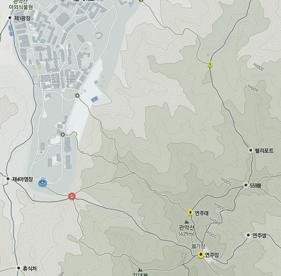
The left branch from the red circle apparently also leads to the top, but is trickier. I’ve done a bit of that and you need to have good shoes for it. Both paths should get you to the top.
My path took me first near Yeonjuam temple from where you can continue either along the mountain ridge, past the weather radar, or go down to the temple and then go up. Both ways get you to the actual summit of Gwanaksan and Yeonjudae shrine. These are the yellow circles on the map. Definitely worth seeing.
Here are some views of the forest on the way up.


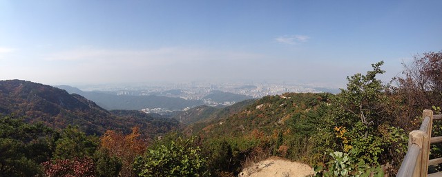
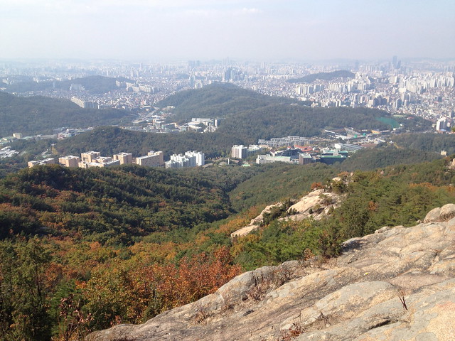
Here are a couple of panorama shots from the top. That’s the reason why one of the guys on the lower photo looks funny since he was moving as I was taking the shot. If you want to see them bigger, go to Flickr, select “All sizes” from the menu, and take your pick.


The circular dome in the pictures is the weather radar which you can also see from our home.
The main attraction, besides the summit and the views, are Yeonjuam temple and Yeonjudae shrine. The latter is, rather typically of such shrines in Korea, built right on a steep cliff. But the view of the shrine and from the shrine are superb.


Here is the temple which is further down.

This is the weather radar and some rocky formations at the top. Unfortunately the power cords were in the way from all possible directions, so I couldn’t get a better photo.

To go down, I decided to take a different path, towards north and leading to Sadang subway station. I had noticed on the map that at the green circle, a path would take me left and down to home, so I figured that would be a nice shortcut. I never quite figured out where the path was, even with a GPS and the map helping me, but a bit further down the path was another branch to the left with a sign Nakseongdae. I followed that and got home quite easily. This path was not on the map, though.
Obviously, I was not the only person on the mountain, as you might guess. There were lots of people everywhere, but not too much to be actually a bother. Only on my little shortcut down was I alone, save for 3 people who I saw coming up, and 3 older, slightly toasted guys going down. Typically Koreans would have some makgeolli when they get to the top; these guys had stopped a few times on the way down to have some more. Can’t really blame them, it was a gorgeous day for a nice outing.
Here is the main path with people and my shortcut with nobody else on it.


The path down to Sadang is definitely harder than the way up from SNU. I’m not saying it’s really difficult, but it does involve using your hands and going up over exposed rock, so you want shoes with good traction. However the views are way better from the Sadang path since it’s more exposed. The SNU path goes basically the whole time in a forest, coming out only at the very end at the top.


All in all, it was a very nice hike. It took me about 4 hours total time and it was really worth it. Going up was a bit tough, especially towards the end, but as soon as I got up, all tiredness simply disappeared. The views were gorgeous and definitely worth climbing up.
Here are some more photos from the hike.
Nice red leaves

SNU campus from Gwanaksan along the Sadang path. Our home is almost in the middle of the photo.
Nice ceneries i like it very much.
Thanks.
Pingback: Gwanaksan | Korea Change