
Eemil Haapanen introduces his MSc thesis
What’s this post about?
I completed my MSc thesis at the Digital Geography Lab, focusing on how cartographic interaction can be applied in exploring massive spatial datasets. More particularly, the dataset I visualized in my work was the Digital Geography Lab’s very own Helsinki Region Travel Time Matrix. In my thesis, I constructed an interactive web map application for visually exploring the data, and carried out a survey on how people used such an interactive application.
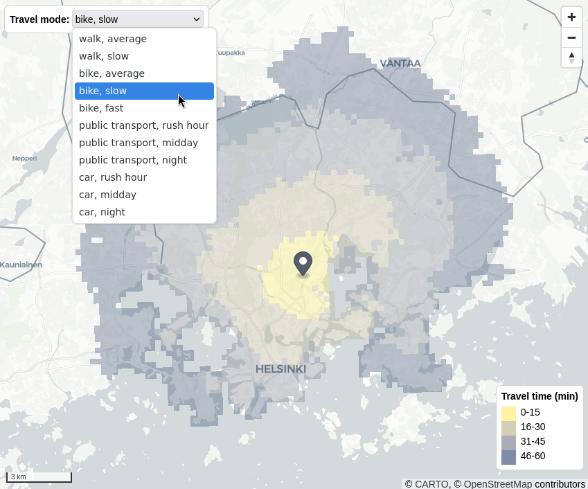
The map application allows for interactively exploring the entire Travel Time Matrix.
Why study cartographic interaction?
Cartographic interaction is often understood as a dialogue between a human and a map. As such, it is a process considered indispensable to reasoning with spatial information – be it analytical map use in a related field of science or, for example, the everyday task of exploring one’s surroundings with a mobile map application. Cartographic interaction is only growing in importance as both the amount of spatial data and the need to better understand it are growing fast. Harnessing the potential of cartographic interaction calls for user-inclusive studies designed around interactive map use, also necessitating the assessment of the rapidly evolving technologies enabling interactive maps.
How did I study this?
In my study, I combined the technology- and user-centric aspects of cartographic interaction. I asked what the performance bottlenecks of a web map application are, and how different web mapping libraries compare as a platform for real-time cartographic interaction. I also asked how users interact with a highly interactive map interface, and whether cartographic interaction changes the way they perceive the mapped phenomenon.
Developing a highly interactive web map application, a map interface to a massive dataset on spatial accessibility (the Helsinki region Travel Time Matrix), was central to my study. I answered my technology-centric questions by assessing the technological aspects of crafting interactive maps throughout this development process. To answer my user-centric questions, I carried out a user survey by combining the web map application with an online questionnaire.
What were the results?
My results show that the geometrical complexity of data, i.e., the number and detail of geometries to render, was the main factor limiting map responsiveness. Notable differences between web mapping libraries existed in the context of dynamic real-time interaction. When it came to map use, survey participants preferred to use the most dynamic mode of map interaction, and perceived the mapped phenomenon differently depending on how they interacted with the map.
My results illustrate how the technologies used in making interactive maps can be both enabling and limiting factors to the map interface. The results also support the wider call for more dynamic map interfaces, indicating that real-time cartographic interaction can be a functional approach to exploring complex and massive data. As a whole, the results highlight the need for the ongoing study of both mapping technologies and map use in order to discover and utilize the potential of cartographic interaction.
In addition to answering my research questions, my work also resulted in an online web map of the Travel Time Matrix. On the map, the user (you!) can explore the entire dataset, choosing to map the accessibility of any location in the Helsinki region by either hovering the mouse above the map or by clicking it. You can also select the travel mode for which the map shows travel times.
- The web map application of the Travel Time Matrix: https://traveltimematrix.rahtiapp.fi/
- The source code of the map application: https://github.com/DigitalGeographyLab/travel-time-matrix-visualisation-frontend
- The MSc thesis in English: https://helda.helsinki.fi/items/a753999a-4748-4cbe-b774-db23e547b0c9
– – – – –
The Digital Geography Lab is an interdisciplinary research team focusing on spatial Big Data analytics for fair and sustainable societies at the University of Helsinki.