Mobile Tartu 2024 – Three inspiring conference days with top-notch presentations and engaging discussions

Mobile Tartu 2024 – one of the highlights of our conference summer – was held on 12-14 June in Tartu, Estonia. Organised by our close colleagues from the Mobility Lab, University of Tartu, this year’s conference focussed on human mobility and mobile big data analytics for just and sustainable societies.

The three conference days of Mobile Tartu 2024 featured a wide variety of paper and poster presentations, engaging panel discussions, and top-notch keynote speeches by Prof Jukka Krisp, Prof Nico Van de Weghe, Assoc Prof Anu Masso and Assoc Prof Robin Lovelace. Many of the current and former members of the Digital Geography Lab were present in Tartu and gathered inspiration from the latest mobility research and fascinating coffee break chats with colleagues from around the world.

Digital Geography Lab members at Mobile Tartu 2024


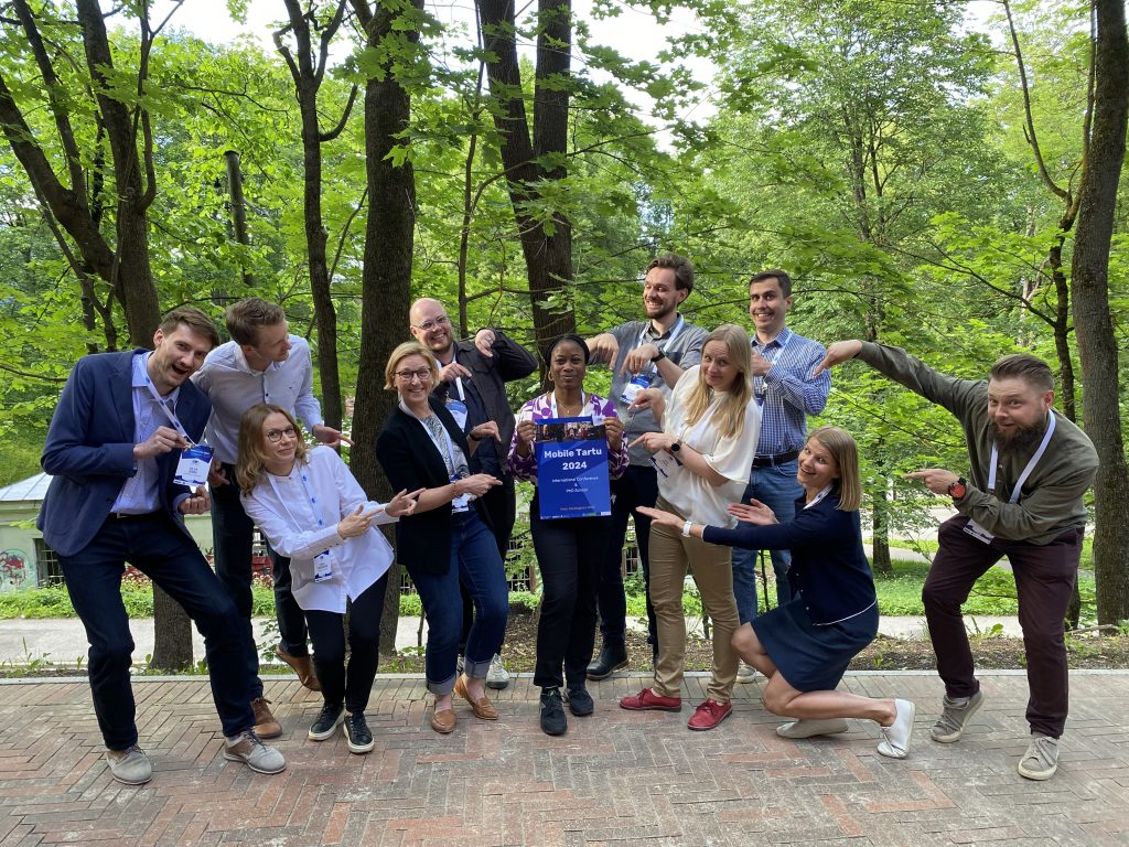
The Digital Geography Lab members had an honour to contribute to the conference programme in multiple ways – by presenting our most recent project results, chairing paper sessions, and participating in a panel discussion. Take a look at the brief photo collection of our presentations at Mobile Tartu 2024. Continue reading “Mobile Tartu 2024 – Three inspiring conference days with top-notch presentations and engaging discussions”

Cartographic interaction for exploring travel time matrices – the development of an interactive web map application and a user survey

Eemil Haapanen introduces his MSc thesis

What’s this post about?

I completed my MSc thesis at the Digital Geography Lab, focusing on how cartographic interaction can be applied in exploring massive spatial datasets. More particularly, the dataset I visualized in my work was the Digital Geography Lab’s very own Helsinki Region Travel Time Matrix. In my thesis, I constructed an interactive web map application for visually exploring the data, and carried out a survey on how people used such an interactive application.

A snapshot from an interactive map exploring the Helsinki Region Travel Time Matrix

The map application allows for interactively exploring the entire Travel Time Matrix.

Why study cartographic interaction?

Cartographic interaction is often understood as a dialogue between a human and a map. As such, it is a process considered indispensable to reasoning with spatial information – be it analytical map use in a related field of science or, for example, the everyday task of exploring one’s surroundings with a mobile map application. Cartographic interaction is only growing in importance as both the amount of spatial data and the need to better understand it are growing fast. Harnessing the potential of cartographic interaction calls for user-inclusive studies designed around interactive map use, also necessitating the assessment of the rapidly evolving technologies enabling interactive maps.

Continue reading “Cartographic interaction for exploring travel time matrices – the development of an interactive web map application and a user survey”

Meet Kirsi Ylinen, a new Research Assistant in the MOBICON project

The Digital Geography Lab is happy to welcome Kirsi Ylinen, a new Research Assistant in the MOBICON project. Kirsi works at the Lab this summer to study the residential background of national parks visitors in the Helsinki Metropolitan Area using mobile phone data. Read more about Kirsi and her research from our mini-interview below.

A profile photo of Kirsi Ylinen


Please briefly introduce your position and research topic at the Digital Geography Lab

Hi! My name is Kirsi Ylinen and I recently started as a Research Assistant in the MOBICON project (Mobile Big Data for Understanding People in Nature) at the Digital Geography Lab. Over the summer, I will be studying national park visitation using mobile phone data. My goal is to understand who the visitors are, but more importantly, who are not visiting the national parks.

In what kind of positions have you worked prior to joining the Digital Geography Lab?

During my MSc studies, I majored in geoinformatics and explored various interesting topics from urban planning to conservation geography. One of the most rewarding experiences of my university journey was working as an assistant teacher in different geography and geoinformatics courses. Additionally, I worked as a geoinformatics intern for the City of Helsinki, where I focused on ecological and green networks within the city. Continue reading “Meet Kirsi Ylinen, a new Research Assistant in the MOBICON project”

Digital Geography Lab contributing to Geoinformatics Research Days 2024

On May 20 and 21, the Geoinformatics Research Days 2024 were hosted at Aalto University. It is a yearly conference initiated by the Finnish University Network for Geoinformatics (Fiuginet). This year’s edition featured researchers from various Finnish institutions working on geospatial topics, but also from abroad. Digital Geography Lab was represented with several contributions.

On Monday, PhD researcher Robert Klein presented his ongoing research on access to travel greenery in major European Cities. He highlighted how temporal variation should not be overlooked when assessing greenery exposure and that there is a trade-off between accessibility and availability of travel greenery in European Cities.

Tuesday started of with a keynote as part of the GeoSPA talk series, organized by our lecturer Kamyar Hasanzadeh. Kamyar invited Franz-Benjamin Mocnick from Paris-Lodron-University of Salzburg to share his work. In his thought-provoking talk, Franz illustrated how simple objects can turn into geographical information by representing places such as tourist attractions, cities, etc. Also, he explained that the communication and representation of places are so subjective and selective, that GIScience is not yet equipped with tools to capture these.

We were also pleased to have our “senior affiliate” Christoph Fink with us for a couple of days. He engaged in the panel discussion on the role of Geo-AI and possible future developments. He pointed out how AI has transformed the work with data in a way that enables researchers to handle immense amounts of data in an increasingly convenient and quick fashion.

Christoph participating in the panel discussion on Geo-AI

Continue reading “Digital Geography Lab contributing to Geoinformatics Research Days 2024”

Meet Mahtab Baghaie Poor, a visiting PhD Researcher from Technical University of Munich

We are excited to share that Mahtab Baghaie Poor, a PhD Researcher from the Technical University of Munich, is visiting us this spring to collaborate on the GREENTRAVEL project. We had a mini-interview with Mahtab to learn more about her research topic and plans for her research stay in Helsinki.

A profile photo of Mahtab Baghaie Poor


Who are you and what is your role at your home university?

I am Mahtab, a research associate at the Technical University of Munich. I’m trained as an urban planner and designer and am currently researching the interactions of urban greenery with the comfort of walking and cycling in my PhD. You can find me on LinkedIn: https://www.linkedin.com/in/mahtab-bp/

Please briefly introduce your research topic.

At the Research Training Group Urban Green Infrastructure (RTG-UGI), we’re a group of researchers looking into various aspects of greenery in cities. We cover a range of topics such as health, tree mortality and growth modelling, ownership, governance, etc and I am looking at the mobility aspect of human-nature interactions. More precisely, I like to understand how urban greenery affects the everyday active mobility experience and how it contributes to a more comfortable daily trip on foot or by bike. In doing so, I have a qualitative approach as the topic requires. I use User Experience capturing methods to go inside people’s heads while walking or cycling and track the live experiences of Munich’s and Helsinki’s residents and the reasons behind their feelings of comfort or discomfort.

Continue reading “Meet Mahtab Baghaie Poor, a visiting PhD Researcher from Technical University of Munich”

Meet Manuel Mendoza Hurtado, a visiting PhD Researcher from University of Cordoba

We are excited to introduce Manuel Mendoza Hurtado, a PhD Researcher from the University of Cordoba. Manuel visits the Digital Geography Lab this spring to collaborate with Academy Researcher Olle Järv on the BORDERSPACE project. Check out our mini-interview with Manuel to learn more.

A profile photo of Manuel Mendoza Hurtado
Photo by Susan Heikkinen


Who are you and what is your role at your home university?

I am Manuel Mendoza Hurtado, a PhD Researcher in the Computational Intelligence and Bioinformatics research group at the Department of Computer Science and Numerical Analysis, University of Cordoba, Spain. I am currently on my last PhD year. I got my Master’s degree in Telematics and Telecommunication networks from the University of Malaga. It was very interesting to learn about mobile networks and telecommunications. My research interests are supervised learning, multi-label classification and dealing with imbalance problems. Currently, I am focused on mobility patterns identification with the use of mobile devices using a machine learning approach as part of my PhD.

Please briefly introduce your research topic.

My PhD thesis “Identification of mobility patterns using advanced artificial intelligence techniques applied to mobile phone data” studies different approaches to identify home and work locations for the users and how could we make use of their mobility patterns to improve public transport planning. I have been working with a multi-source dataset from the city of Milan, with Call Detail Records using classification algorithms to detect home and work locations. Continue reading “Meet Manuel Mendoza Hurtado, a visiting PhD Researcher from University of Cordoba”

Big data, big changes: Project MOBICON in the Canary Islands for a workshop and presentations

The Canary Islands are a biodiversity, geodiversity and tourism hotspot, boasting one of the most visited national parks in Europe (Teide in Tenerife). Tourism is the backbone of the local economy, but the growing masses of visitors put an unsustainable strain on the islands’ beautiful nature.

A collage of six photos: three of them of workshops and lecture halls, three from nature.

The islands are also acutely impacted by climate change and other megatrends including aging of population in Europe or digitalisation changing work life. On top of the traditional tourists, the islands are now receiving masses of long-term visitors seeking warm wintering grounds on the islands.  

These factors make the Canary Islands an interesting study area for the MOBICON project, where we study changes in nature visitation and their impacts on biodiversity conservation as well as the applicability of mobile big data sources for extracting visitor information.  

We (team Mobicon: Aina, Matti, Tatu and Tuuli) visited the islands of Gran Canaria and Tenerife in March 2024 for establishing collaboration with local universities and to collect research data through stakeholder discussions. Some highlights of the trip below.

Continue reading “Big data, big changes: Project MOBICON in the Canary Islands for a workshop and presentations”

Changes in nature visitation and the potential of mobile big data for visitor monitoring – Report from an expert workshop out now!

Aina Brias Guinart introducing a workshop task to the participants.

The importance of natural areas for recreation and conservation alike is critical, yet we often don’t know how many people visit them and why. Such information is necessary for the management and development of natural areas, which is why research by our lab and others have considered mobile big data sources (think data from mobile phones, social media etc.) as a way to monitor outdoor recreation. Yet, translating scientific research into actionable information for management is not straightforward – is it even wise? What kind of information do managers of natural areas need? What sort of changes do they managers see, how do these affect their information needs, and what sort of larger trends drive these changes? 

Researchers in project Mobicon called together experts from Finnish nature organizations to reflect on these questions in September 2023. The aim of the workshop was to collect expert opinions related to the changes in the recreational use of nature, the monitoring needs related to the changing visitations, and to discuss the possibilities of various new data sources to meet managerial information needs. 

This workshop was the first of a series repeated in March 2024 in the Canary Islands. We have now released a report on the outcome of the Helsinki workshop. Check it out! 

In English: https://doi.org/10.31885/2024.030501 

Suomeksi: https://doi.org/10.31885/2024.030502 

If you wish to cite the reports, you may use:

Toivonen, T., Brias Guinart, A., Eklund, J., Hästbacka, M., Leppämäki, T. and Torkko, J. (2023). Potential of mobile big data for visitor monitoring: Report of the MOBICON workshop held in Helsinki 28.9.2023. Helsinki: Digital Geography Lab, University of Helsinki. doi:10.31885/2024.030501

– – – – –

The Digital Geography Lab is an interdisciplinary research team focusing on spatial Big Data analytics for fair and sustainable societies at the University of Helsinki.

Meet Xiao Cai, a visiting MSc student from University of Tartu

We are happy to introduce Xiao Cai, a geoinformatics MSc student from the University of Tartu. Xiao is visiting the Digital Geography Lab this spring, from February to May 2024, to study the influence of road environments on cyclists’ route choices in Helsinki and finalize his thesis. We had a mini-interview with Xiao to learn more about his previous and future research.

Xiao Cai presenting his research


Who are you, and what is your role at your home university? 

My name is Xiao Cai, with a mixed academic background of urban planning, geoinformatics, and artificial intelligence (AI). I am currently doing a master’s program in Geoinformatics at the University of Tartu and expect to graduate in June this year.

Please introduce your research topic.

I am a big fan of urban informatics with a dedicated focus on AI approaches to uncovering urban mobility mechanisms using emerging geospatial big data. I was exposed to AI methodologies in 2022 by taking a machine learning course, but since then I have been highly motivated to leverage this powerful technique in urban mobility analyses. Up to now, I produced two papers in this regard – the one is to mine the hidden spatiotemporal characteristics of bike-sharing travel patterns using the k-means++ clustering algorithm, and the other one is to examine the non-linear associations of built environments with demographic-specific bike-sharing usage using the gradient boosting decision tree algorithm. In the near future, I would like to explore more possibilities of using AI methodologies (machine learning or neural networks) to understand the hidden patterns of population dynamics and potential causes. I am also looking forward to exploring more big mobility data (e.g., mobile phone data, smartcard data, e-scooter data, taxi data, etc.) as I am always excited when working with data.

Continue reading “Meet Xiao Cai, a visiting MSc student from University of Tartu”

Meet Matti Hästbacka, a Doctoral Researcher in the MOBICON project

We are excited to introduce Matti Hästbacka! 🙂 Matti works as a Doctoral Researcher in the MOBICON project (Mobile Big Data for Understanding People in Nature). Check out our mini-interview with Matti to learn more about his research and interests.

Matti's profile photo


Who are you and what is your position at the University?

My name is Matti Hästbacka, and I’m a Doctoral Researcher in the MOBICON project (Mobile Big Data for Understanding People in Nature) at the Digital Geography Lab. In my thesis, I employ mobile big data and novel methods to understand the changing carbon footprint of nature-based tourism.

In what kind of positions have you worked prior to joining University?

I graduated with an MSc in Geography from the same department where I’m currently working. In my MSc studies, I majored in Geoinformatics, but I tried to make the most of academic freedom throughout my studies, and ended up studying a lot of different things, ranging from Natural Language Processing and statistics to Latin American studies. To me, the ability to study a wide variety of courses has been the best part of my studies so far. In my MSc thesis, I used Flickr data and spatial analysis coupled with computer vision methods to understand the importance of nature for tourists visiting the Canary Islands.

At the same time, I’ve been working in the Emergency Medical Services field as a planner.

Continue reading “Meet Matti Hästbacka, a Doctoral Researcher in the MOBICON project”