
One of the goals of the BORDERSPACE project at the Digital Geography Lab is to examine whether and how social media data such as geo-located Twitter data can reveal cross-border mobility of people and provide new insights for understanding border regions. We demonstrate the feasibility of using Twitter data in two different recently published studies – the first study from the Greater Region of Luxembourg and the second study from the Nordic countries.
Study #1: “Revealing mobilities of people to understand cross-border regions: insights from Luxembourg using social media data”
Published in European Planning Studies
Authors: Olle Järv, Håvard W. Aagesen, Tuomas Väisänen & Samuli Massinen
Conceptually, our approach was to make big data small and meaningful by: 1) using a bottom-up concept of activity space (e.g. Järv et al., 2014); 2) using mobility as a tool to capture individual activity spaces; and 3) contextualizing mobility from the border perspective.

Methodologically, we demonstrated the value of geotagged tweets – inherently transnational data – as a promising data source for studying cross-border mobility and social interactions around the world.
Empirically, we demonstrated who are crossing the borders of Luxembourg by various population groups: cross-border commuters, other locals within the Greater Region of Luxembourg, and non-local tourists from elsewhere. We mapped the estimated geographical distribution of cross-border mobility flows to and from Luxembourg, and captured the temporal dynamics of border crossings – weekly and monthly rhythms, and yearly trends. Finally, we evaluated our findings against existing sources to demonstrate the feasibility of the proposed approach as the proof-of-concept for cross-border research.

The discussion focused on current challenges of our approach and mapped avenues to improve the implementation of our approach for cross-border research, e.g. capturing people’s transport mode; social networks; place attachment and engagement to a society; and language use (e.g. Väisänen et al. 2022). We further highlighted how new insights from our approach can contribute to the research and practice for regional planning and cohesion policies of border regions – for example, to defining functional border regions through the cross-border mobility of people as an indicator for a functioning and integrated region (e.g. Aagesen et al. 2022).
Study #2: “The effect of COVID-19 on cross-border mobilities of people and functional border regions: the Nordic case study from Twitter data”
Published in Geografiska Annaler: Series B, Human Geography
Authors: Håvard W. Aagesen, Olle Järv & Philippe Gerber
Conceptually, we used a global approach focusing on generic flows of cross-border mobilities without classifying population groups and/or mobility forms – in a way “let the data speak to itself”. For delineating the geographical extent of border regions, we considered the functional region to be an organizational structure based on spatial interactions – interactions that we can spatially observe such as movements of people and social interactions between people located in different places.
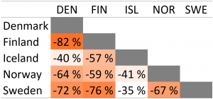
Empirically, we attempted to reveal how cross-border mobility was affected by the first wave of COVID-19 between the five Nordic countries compared to baseline period before the pandemic using geotagged Twitter data. We found that overall cross-border mobility decreased by 68% due to the pandemic, yet with geographical and temporal variations. For example, our approach detected the significant increase of Finns visiting northern Norway in summer 2020 as an alternative vacation destination while other international travel was not allowed. Furthermore, we explored that mobility across borders enables us to reveal functional border regions and their structural changes caused by COVID-19.

The discussion focused on the assessment of the feasibility of using Twitter data for studying border regions and transnational phenomena. As transnational phenomena are fragile to global disruptions and prone to ‘rebordering’ in times of emergency, we lack knowledge of how crises like the COVID-19 pandemic affect border practices and functioning regions due to lack of suitable data. Our simple approach could already be used for continuous monitoring of cross-border mobilities over time and functional border regions to improve planning and development of border regions. Finally, our study attempted to promote further development of our approach.
We promote open science by sharing our code!
To promote reproducibility, our notebooks and code for data collection, processing and analysis are openly available on GitHub for both studies: Study #1 and Study #2. Feel free to make use of our code to improve our methodology for enhancing border and mobility research! 😉
– – – – –
The BORDERSPACE project focuses on studying cross-border mobilities and interactions, transnational people, and functional transnational spaces. The novelty of the project stems from the use of novel big data sources to provide valuable insights for cross-border research and practice. The project is carried out at the Digital Geography Lab — an interdisciplinary research team focusing on spatial Big Data analytics for fair and sustainable societies at the University of Helsinki.