
I have a course in this period about geoinformatics. We have some course supportive reading in English that is non mandatory to pass the course or to get the required credits. I decided to get familiar with the English terms and vocabulary of geoinformatics.
Geoinformatics studyes spatial information using the geographic information system (GIS). Spatial information is basically information that has location connected to it. For example, Google Maps, Instagram, Facebook and other social media channels all contain spatial information. Google maps shows us a way to quickly get from point A to point B, and Instagram let our followers know where we had been the moment when the photo was taken. Facebook can advertise us content based on our current location.
I read the article “Interpolating Surfaces in ArcGIS Spatial Analyst”, written by Colin Childs (2004). Interpolation is a way of visualising and analysing spatial data. Spatial data can be points, lines or areas. Data can be vector based or raster based. Interpolation is a tool that can predict what information is around a spatial data point. For example, most of large weather forecasts are made with interpolation. No one can measure the exact temperature everywhere in Finland, but with interpolation one can guess what value the surrounding areas contain.
Interpolation is never completely accurate, and there are plenty of different ways to do interpolation. Spatial autocorrelation is an important aspect to know before analysing the data any further. Spatial autocorrelation defines whether the data and values have any connection or correlation between them. For example, values that are close to each other are usually more similar than values that are far away.
When choosing the appropriate method, the user must know what is the best way of interpolation for the user’s data. Some interpolation methods are local like the TIN and IDW methods, and others are global like, for example, the trend surface. Local means that only the nearby values affect a point’s value, and global means that by changing one value, the others are also affected.
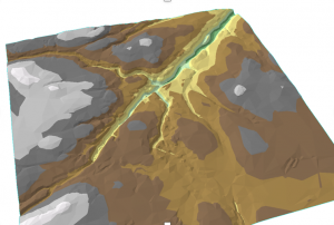
Here are a couple of maps I have made using interpolation.

Hours: 30+3=33