
Overview of Joose Helle’s MSc thesis
Exposure to noise pollution can cause various adverse health effects such as increased blood pressure and stress levels. Noise exposure has traditionally been assessed in terms of home location, as required by national and international policies. However, a substantial share of individuals’ total daily noise exposure is likely to happen while they are on the move. This evidently also affects the healthiness of active travel modes, walking or cycling, by reducing or even outweighing positive health effects of physical activity. Thus, there is a clear need for advancing exposure assessment beyond residential location to gain a true understanding of exposure profiles and their potential effects on health and well-being.
Journey-time exposure assessment can study spatially dynamic exposure to pollutants as people move through the urban environment. Furthermore, least-cost routing can be applied to find healthier paths with lower exposure levels to pollutants. This novel research field has a potential to support urban sustainability and equitability through increasing awareness of the qualities of travel environments, assessing population exposure, supporting individual mobility choices as well as planning healthier travel infrastructure throughout the urban fabric.
These tasks are not trivial. How to assess dynamic exposure to noise pollution? How to find routes with less noise than on the shortest route? How to develop a mobile navigation application for exposure-based route planning? These were the key questions I addressed in my master’s thesis: Quiet paths for people: developing routing analysis and Web GIS application, defended in May 2020 at the University of Helsinki.
In my thesis, I developed a routing application for 1) finding shortest paths, 2) assessing exposure to traffic noise on the paths and 3) finding alternative, quieter paths. This “quite path” application uses street network data from OpenStreetMap and modelled traffic noise data of typical daytime noise levels. The underlying least-cost path analysis employs a custom-designed environmental impedance function for noise and a set of noise sensitivity coefficients.
After developing the quiet path routing application, I applied it for assessing pedestrians’ dynamic exposure to noise on their routine local walks in the Helsinki region. The case study assessment included public transport itinerary planning analysis by census-based commuting flow data. In addition, I assessed the performance of the quiet path routing method by inspecting achievable reductions in traffic noise exposure on 18446 modelled commuting related walking routes. In other words, I assessed the potential of the quiet path routing method for reducing pedestrians’ exposure to noise under different circumstances.
The results of my analysis show that there is a significant spatial variation in average dynamic noise exposure between different neighbourhoods (Figure 1). That is followed by significant achievable reductions in noise exposure if quieter paths are preferred. Depending on the conditions, quieter paths provide 1.6–9.6 dB mean reduction in mean noise level and up to 57% mean reduction in exposure to high noise levels (65 dB and above) when compared to the shortest paths (Figure 2). According to the results, at least three factors seem to affect the reductions in noise exposure on alternative paths: 1) noise levels on the shortest path, 2) length of the quiet path compared to the shortest path and 3) length of the shortest path (i.e. the distance between origin and destination).
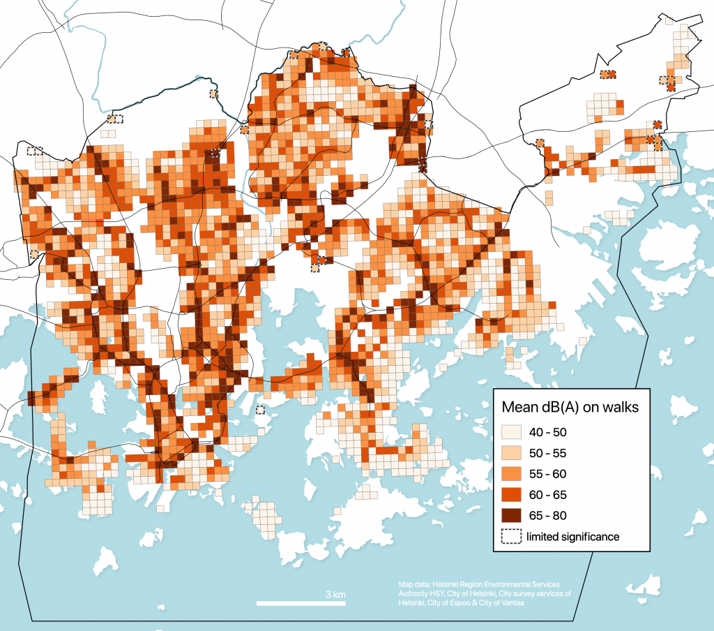
Figure 1. Mean traffic noise level (dB) on local walking routes from home to closest public transport stops. The averages are weighted with the estimated utilization rates of the routes.
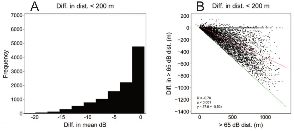
Figure 2. Histogram of reductions in traffic noise exposure as difference in mean noise level (dB) (A) and reductions in traffic noise exposure as difference in exposure to +65 dB noise (m; i.e. “> 65 dB dist.”) (B) on quiet paths less than 200 m longer than the respective shortest paths (path length: 700–1300 m; n=11355).
Having found the significant achievable reductions in dynamic noise exposure, the next logical step was to develop and publish the quiet path routing method as a web-based route planner application. The application is composed of open quiet path routing API and a mobile-friendly web map application (Figure 3). The quiet path route planner demonstrates the applicability of the quiet path routing method in real-life situations and thus can help pedestrians to choose quieter paths.
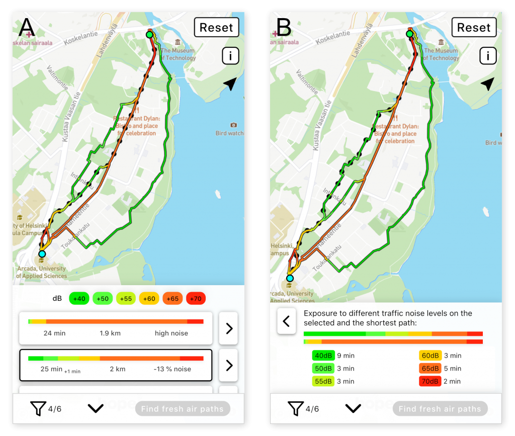
Figure 3. The user interface of the quiet path route planner when (A) showing several alternative paths (one shortest path and three quiet paths) and (B) showing exposure to noise on a selected path.
All methods and source codes developed in the thesis are openly available via GitHub. I hope that this work will increase awareness of individuals’ dynamic exposure to pollutants and accelerate the development of exposure-based routing tools. Together with our research group, we also welcome various collaboration in exposure studies and offer research themes for master studies.
Read the whole thesis in HELDA.
The quiet path routing application is already being developed further towards a multifunctional Green Paths route planner within the UIA HOPE project (Urban Innovative Action HOPE – Healthy Outdoor Premises for Everyone). In the project, more environmental factors have been or will be incorporated to the least-cost routing tool, including real-time air quality based on the modelling system of Finnish Meteorological Institute, and green views gained from Google Street View imagery.
Access the mobile-friendly Green Paths routing tool at green-paths.web.app.
Explore the source codes in github.com/hellej/quiet-paths-msc
(for the latest version, see also github.com/DigitalGeographyLab/hope-green-path-server and github.com/DigitalGeographyLab/hope-green-path-ui).