
Håvard Wallin Aagesen introduces his MSc thesis
How can Twitter data be used to study cross-border regions in the Nordics? And how are the effects of the COVID-19 pandemic reflected in the spatial pattern of Twitter usage? These were some of the questions that Håvard Wallin Aagesen, a fresh PhD candidate at the Digital Geography Lab, addressed in his MSc thesis “Understanding Functional Cross-border Regions from Twitter Data in the Nordics“. In this blog post, Håvard looks back to and summarizes his MSc work.
Why this matters?
As part of the BORDERSPACE project, I set out to investigate how cross-border interactions in the Nordic countries can be studied, using Big Data from Twitter. In light of the COVID-19 pandemic, a newfound need for studying cross-border flows has arisen, and Twitter data could provide the possibility to quickly and easily explore the changes in human mobility patterns before and during the pandemic.
The Nordic region is a connected region with a long history of cooperation, shared cultures, and social and economic interactions. Cross-border cooperation and cross-border mobility has been a central aspect in the region for over half a century. Despite of shared borders and all countries being part of the Schengen Area, allowing free movement, little research has been made on the extent of daily cross-border movements and little data exist on the topic.
As a well-connected region, the Nordic region saw a sudden decrease in mobility and areas across borders were suddenly isolated from each other. The spread of the COVID-19 virus, and the most important measures to counter the pandemic, have been spatial in their nature. Restrictions on mobility, and lockdown of regions and countries have been some of the measures set in place at varying degrees in different locations. Understanding the effects of mobility on the spread of COVID-19 and effectiveness of different measures is important in handling the ongoing and future pandemics.
Methods
In my thesis, I collected geotagged Twitter data from March 2019 to February 2021 to be able to utilize a person-based approach to reveal the spatial extents of human mobility across the Nordic countries, both before (March 2019 – February 2020) and during the COVID-19 pandemic (March 2020 – February 2021). With 11M tweets from 21K users, I was able to reveal cross-border movements (Figure 1), and to infer functional cross-border regions (using a kernel density estimation) in the Nordics.
All the scripts and codes used in the MSc thesis can be found in this Digital Geography Lab GitHub-repository.
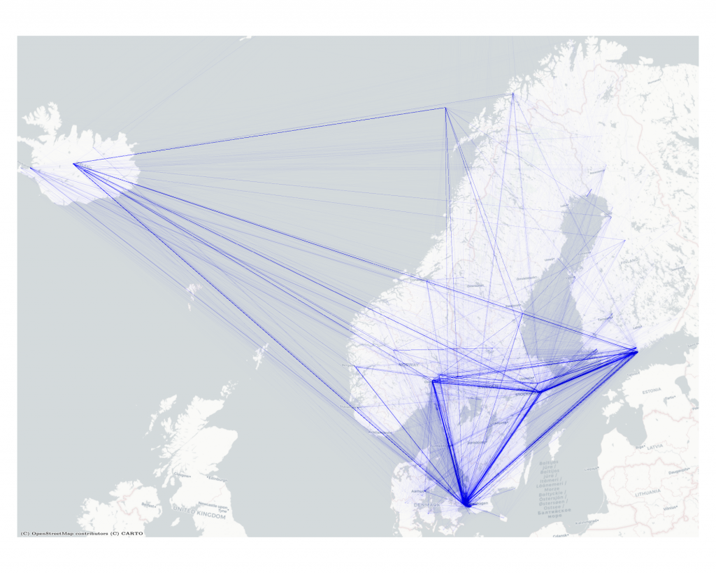
Figure 1. Cross-border movements in the Nordics derived from 11M tweets from 21K users.
The estimations of functional cross-border regions based on human mobility before and during the pandemic clearly showed the effect of COVID-19 and the measures taken to limit cross-border mobility. The volume of cross-border mobility reduced severely (Figure 2), and the composition of functional regions changed differently in different regions. In general, the spatial extent of cross-border regions reduced and gravitated towards the largest cities on either side of the border in all Nordic countries.
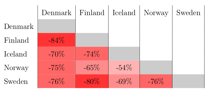 Figure 2. During the COVID-19 period, the volume of cross-border mobility between countries decreased severely, while it varied between different country pairs.
However, when delineating functional cross-border regions, one has to remember that spatial scale matters. When looking at the cross-border mobility between Finland and Sweden, running a kernel density estimation with travels starting and ending on either side of the border provided different results depending on which spatial level was investigated. At the national level, taking into account all travels between the two countries, there are clear indications of strong connections between the capital cities with most start and end points of travels being clustered around Helsinki and Stockholm (Figure 3).
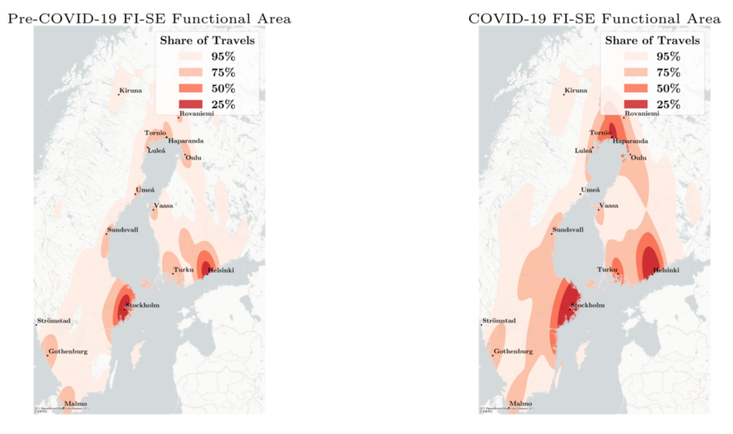 Figure 3. Functional cross-border regions between Finland and Sweden on the country level.
When subsetting the data to the northern regions of both Finland and Sweden (Figure 4), another clear functional cross-border region appears. The area around Tornio (FI) and Haparanda (SE) is known to be tightly connected, something that the functional cross-border region derived from Twitter data also shows. Most travels in the region start and end close to the two cities. As smoothing is inherent in kernel density estimation, lower spatial levels provide more detailed results.
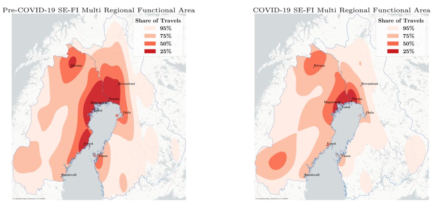 Figure 4. Functional cross-border regions between Finland and Sweden on the multi-regional level.
Finally, focusing only on the most northern NUTS 2 regions of Finland and Sweden, the functional cross-border region around Tornio and Haparanda becomes very clear (Figure 5). The changes in travel patterns from the year preceding the COVID-19 travel restrictions are also evident and spatially unevenly distributed. For instance, the cities of Kiruna (SE) and Rovaniemi (FI) seem to be affected to a larger degree than Tornio and Haparanda. A similar effect of spatial scaling on delineating cross-border regions was found for all countries in the Nordic region.
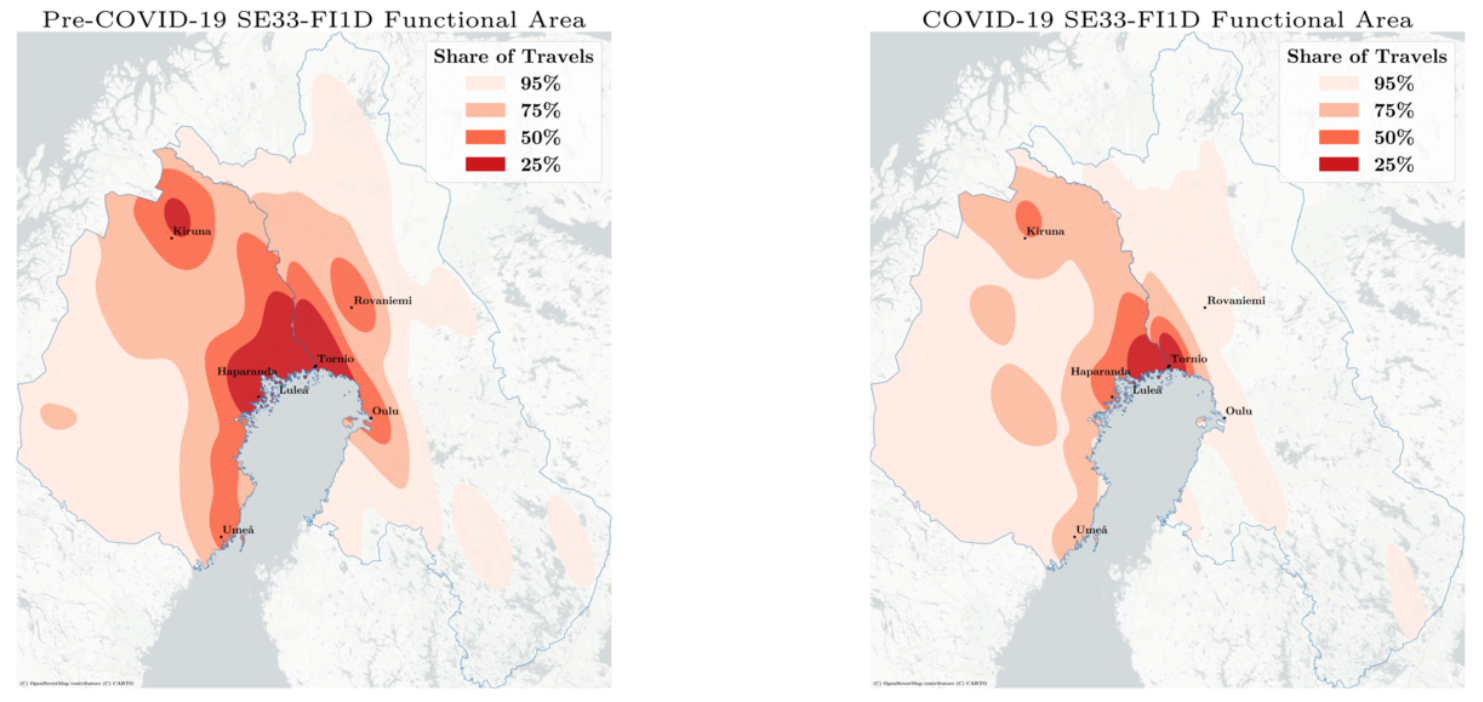 Figure 5. Functional cross-border regions between Finland and Sweden on the regional level (NUTS 2).
The methods and results developed in this thesis provide new insights into the dynamics of mobility flows in the Nordic region and are first steps to make more use of novel data sources in cross-border mobility research in the Nordics. Further research into methods for expanding the data basis, and for deepening the understanding of demographic and temporal aspects of functional cross-border regions is however needed.
Read the full MSc thesis here: Understanding Functional Cross-border Regions from Twitter Data in the Nordics.
The BORDERSPACE project, led by Academy Research Fellow Olle Järv, combines cutting edge big data analytics and critical theorizations to study the socio-spatial phenomenon of transnationalism through bordering practices of people. The novelty of the project stems from the use of novel big data sources with the purpose of providing valuable insights for cross-border research and practice. The project is carried out at the Digital Geography Lab, University of Helsinki. The Digital Geography Lab is an interdisciplinary research team focusing on spatial Big Data analytics for fair and sustainable societies.