Vuokko’s lectio 9.12.2020

User-generated Geographic Information for Understanding Human Activities in Nature

Lectio Praecursoria, in the public examination of MSc Vuokko Heikinheimo’s doctoral dissertation
the 9th of December 2020


Nature contributes to human well-being in countless ways. Many of us enjoy spending time in nature, going for a walk or a picnic and observing species and seasons. Nature-based tourism and outdoor recreation are evident examples of direct benefits of nature to people.

National parks are protected areas that are dedicated to safeguarding biodiversity and providing people the opportunity to enjoy nature.

Urban green spaces include the network of parks, forests and other green areas in the urban structure. Green spaces in cities offer opportunities for contact to nature in our everyday lives while protecting urban biodiversity.

We are also willing to travel far in order to experience and enjoy nature. In many places, visitors of protected areas – both domestic and international – are a significant source of income for park management and local communities. Information about protected area visitors is important for planning and management on regional, national and international scales.

The ongoing pandemic has emphasized the importance of access to green spaces in everyday life.

Continue reading “Vuokko’s lectio 9.12.2020”

Inaugural lecture by Professor Toivonen

Tuuli Toivonen is now a full professor in geoinformatics at the Faculty of Science!

Newly appointed  professors at the University of Helsinki are celebrated twice a year. As part of these celebrations, the professors hold an inaugural lecture.  This autumn, all festivities were (understandably) held online which allowed everyone interested to watch these lessons online.You can watch Tuuli’s lecture in here (Finnish audio, Finnish and English subtitles available):

Congrats once more to Tuuli!

NoRSA 2019 Keynote: Tuuli Toivonen

We will also start sharing our presentations in the Digital Geography Lab blog!

To start out, we will share Tuuli’s Keynote presentation at NoRSA 2019 Conference Seinäjoki, Finland, 19th June 2019 that summarizes much of our ongoing work related to socio-spatial interactions and Big Data:


A new paper on understanding the use of urban green spaces from user-generated data

Parks and other green spaces are an important part of sustainable, healthy and socially equal urban environment. Urban planning and green space management benefit from information about green space use and values, but such data are often scarce and laborious to collect. Temporally dynamic geographic information generated by users of different mobile devices and social media platforms are a promising source of data for studying green spaces.

Social media data, sports tracking data, mobile network data and PPGIS data from green spaces
Examples of social media data, sports tracking data, mobile phone data and PPGIS data from green spaces in Helsinki, Finland.

In a recent article published in the Landscape and Urban Planning journal we compare the ability of different user-generated data sets to provide information on where, when and how people use and value urban green spaces. We compare four types of data: social media, sports tracking, mobile phone operator and public participation geographic information systems (PPGIS) data in a case study from Helsinki, Finland, and ask: 1) where the spatial hot-spots of green space use are, 2) when people use green spaces, 3) what activities are present in green spaces and 4) who are using green spaces based on available sample data sets.

Continue reading “A new paper on understanding the use of urban green spaces from user-generated data”

Congratulations Claudia, Hertta and Elias for the City of Helsinki Master’s thesis award!

Yearly award for the best Master’s thesis have been again presented by the city of Helsinki on Monday the 9th of December 2019. We at the Digital Geography Lab would like to give special congrats to three awarded GIS wizards from the Department of Geography and Geosciences, Univerisity of Helsinki: Claudia Bergroth, Hertta Sydänlammi and Elias Willberg!

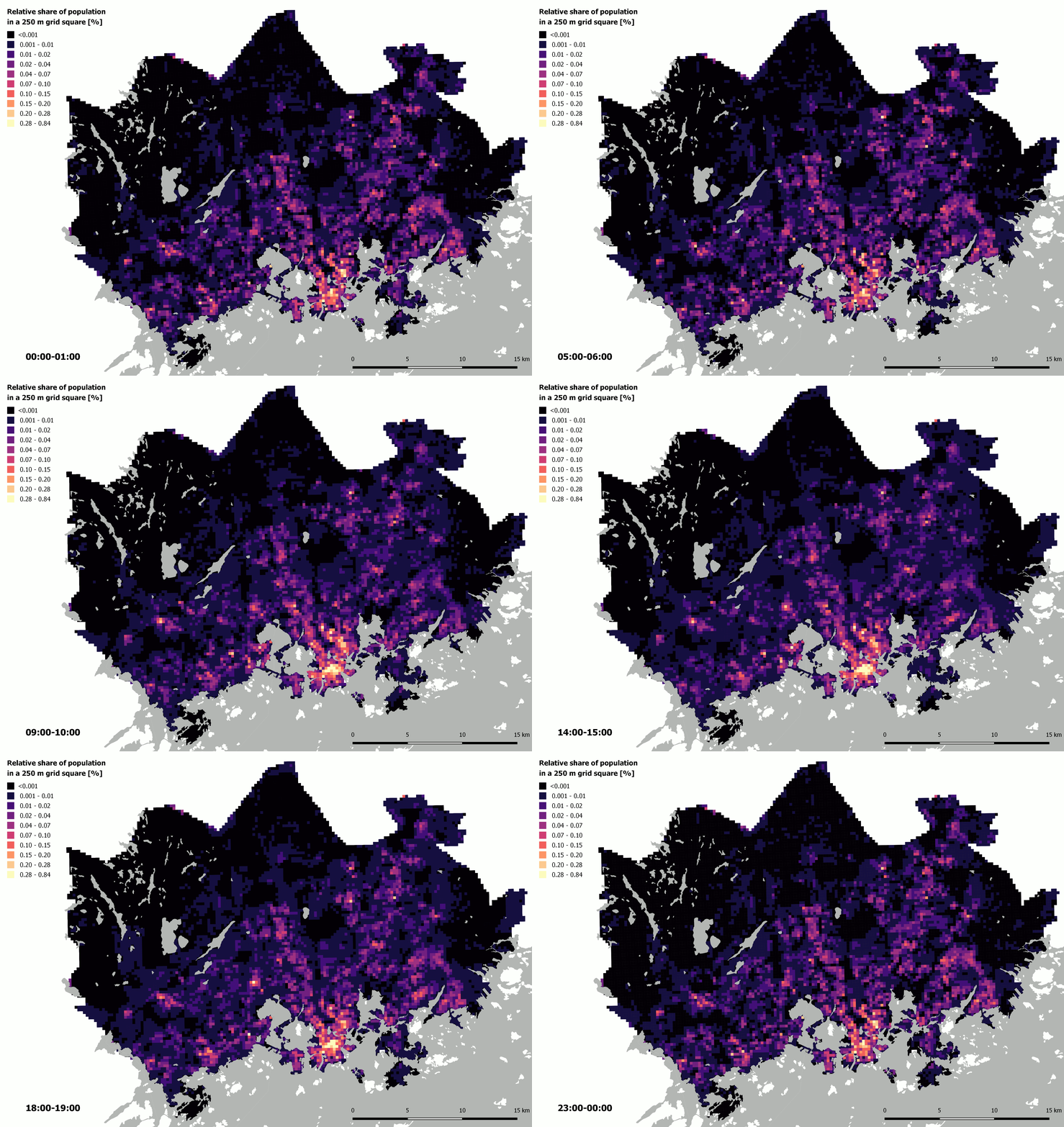
Bergroth Claudia (2019): Uncovering population dynamics using mobile phone data: the case of Helsinki Metropolitan Area.

The estimated hourly distribution of people on an average weekday in the Finnish Capital Region based on network-driven cellular mobile phone data. Read more about Claudia’s work in this blog post. 

Continue reading “Congratulations Claudia, Hertta and Elias for the City of Helsinki Master’s thesis award!”

How green are the streets of Helsinki?

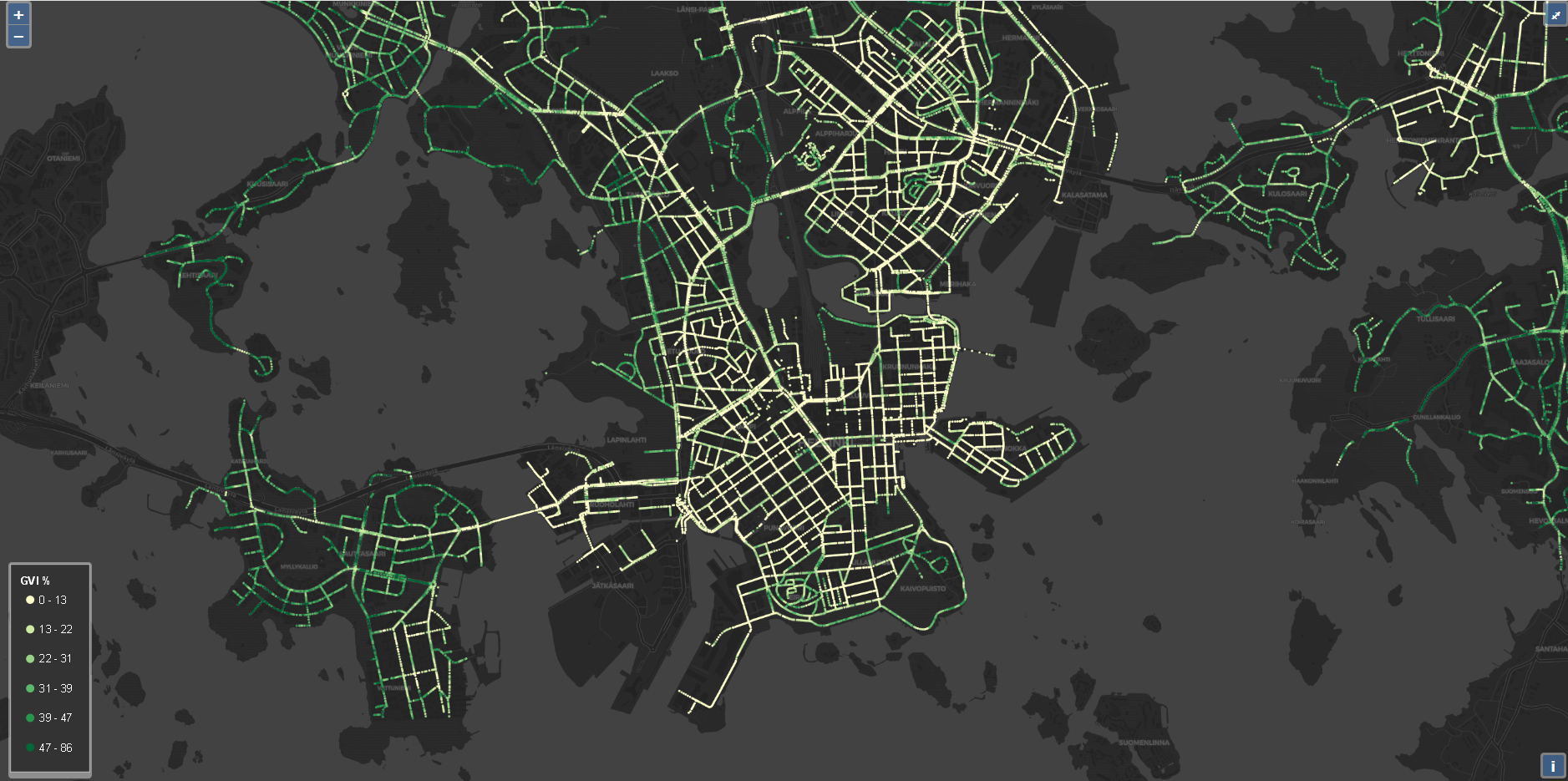
Overview of Akseli Toikka’s MSc thesis: Mapping the green view of Helsinki through Google street view images

Interactive webmap for the Green View Index across Helsinki

Click to browse the interactive GVI map of Helsinki.

Urban vegetation has traditionally been mapped through traditional ways of remote sensing like laser scanning and aerial photography. However, it has been stated that the bird view examination of vegetation cannot fully represent the amount of green vegetation that the citizens observe on street level. Recent studies have raised human perspective methods like street view images and measuring of green view next to more traditional ways of mapping vegetation. Green view index (GVI) states the percentage of green vegetation in street view on certain location. The purpose of my thesis was to create a green view dataset of Helsinki city using Google street view (GSV) imagery and to reveal the differences between human perspective and aerial perspective in vegetation mapping.

Continue reading “How green are the streets of Helsinki?”

Environmental dialogues: how to plan for urban biodiversity?

Earlier this week, Henna Fabritius took part in the environmental dialogues -event  to discuss biodiversity-related modelling tools in urban greenery planning.

More information, and a recording of the event is available here (in Finnish):

Ympäristödialogeja: Miten suunnitella monimuotoista luontoa?

The event was organized by the Forum for Environmental Information (Ympäristötiedon foorumi in Finnish), which is a non-profit organization that aims at increasing interaction between the producers and users of environmental information in order to support national policy making in Finland, while keeping in mind the global significance of environmental problems.

Read also Henna’s blog about getting better at supporting urban biodiversity (in Finnish):
https://www.nessling.fi/ymparistodialogeja/mina-vaitan-luonnon-monimuotoisuutta-voitaisiin-tukea-kaupungeissa-nykyista-enemman/