The 24-h population dynamics of the Finnish Capital Region uncovered!

Figure 1. The estimated hourly distribution of people on an average weekday in the Finnish Capital Region based on network-driven cellular mobile phone data.

Understanding where people are and when – What is the pulse of the city? – is of high importance in urban planning, management and governance. Accurate information of the dynamic population distribution is crucial for example for land use and transport planning, disaster and conflict preparedness, evacuation purposes and for mitigating the spreading of diseases.

So far, our understanding of the whereabouts of people in time and space is scarce and predominantly based on static census data – people are expected to stay at home, although people rarely stay there the entire day. For instance, in (place-based) spatial accessibility research the use of home locations are considered as a proxy for origins of people despite the widely acknowledged criticism of the approach.

Fortunately, novel temporally sensitive spatial data sources, such as mobile phones, geotagged social media posts and smart cards can provide new solutions to uncovering the actual whereabouts of population in space and time.

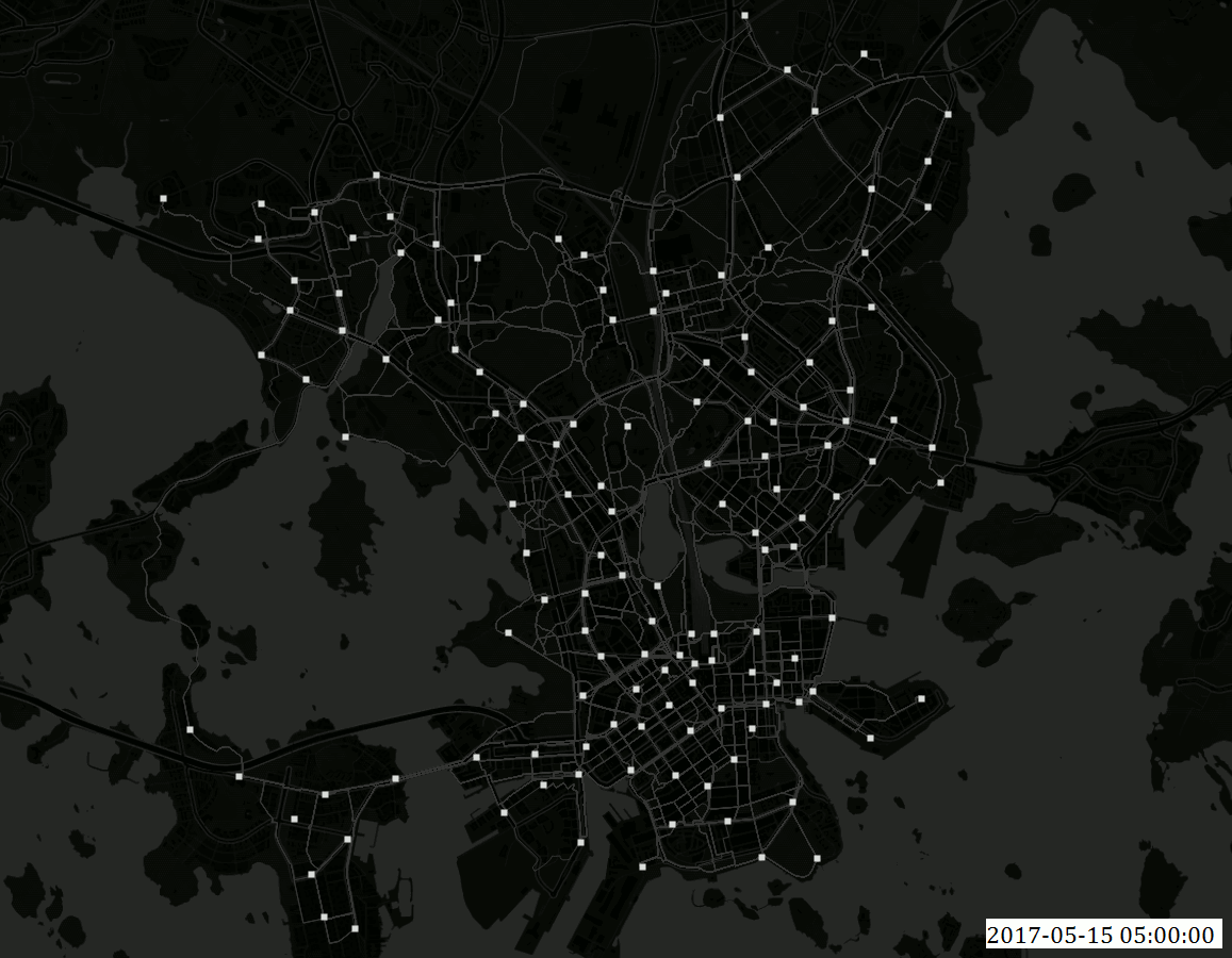
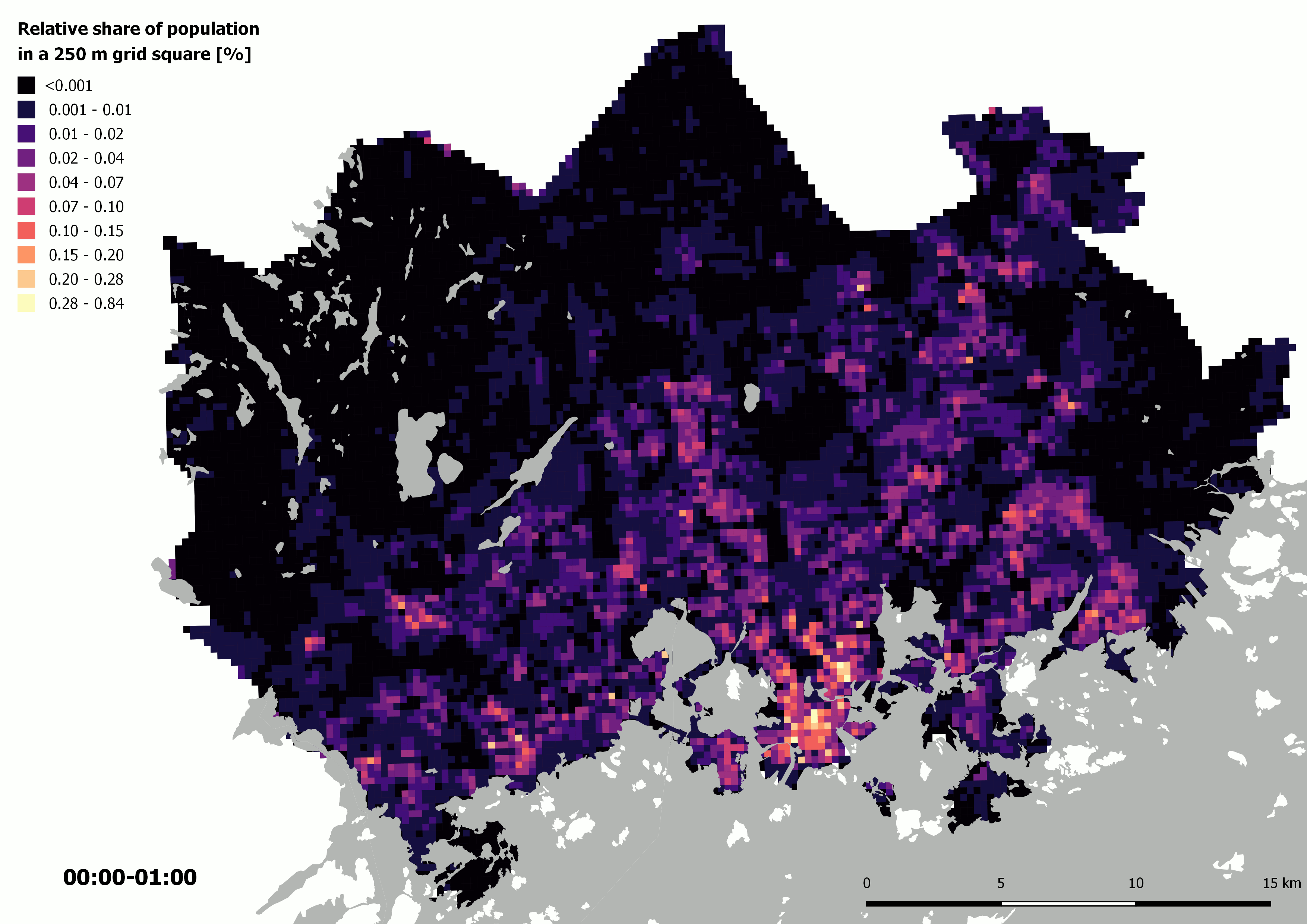
In my thesis, I set out to uncover the spatio-temporal population dynamics in the Finnish Capital Region using mobile phone data. The data was provided by one of the main mobile network operators in Finland. Network-driven mobile phone data was interpolated to statistical 250 m x 250 m grid squares to estimate the hourly population distribution on a typical weekday (Monday-Thursday).

To refine the estimated population distribution derived from mobile phone data, I applied and adapted an advanced interpolation method developed by the Digital Geography Lab that uses ancillary information of land use, floor area and use type of buildings, and a time use survey to improve the accuracy of the results. The results were then validated against official census data during night-time (2 AM – 5 AM), which showed that the advanced interpolation method significantly improves the population distribution derived from mobile phone data.

Figure 2. The estimated hourly weekday distribution of people in six individual 250 m x 250 m grid cells. The graphs show the share of present population in the given grid square of the hourly total of all grid cells in HMA.

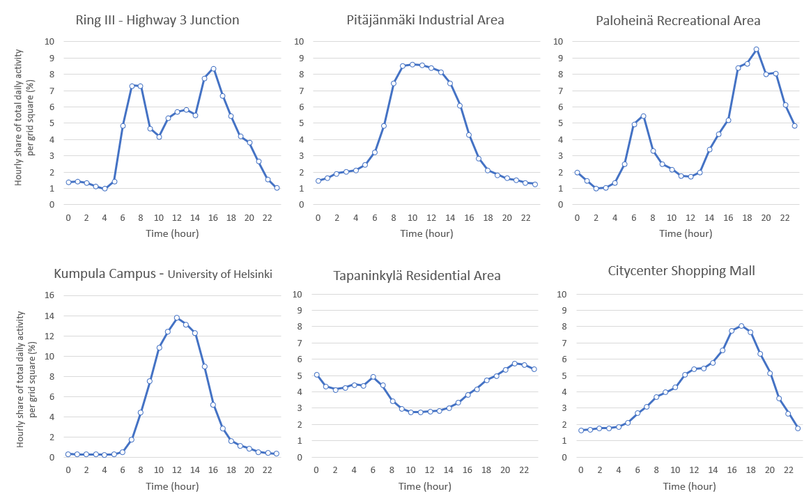
The results highlight, that network-driven mobile phone data can be used to catch the daily pulse of the Finnish Capital Region. The morning hours show a clear transition in the whereabouts of people from residential areas to work place areas. The afternoon pattern is however not as straightforward – people may stop by a store or undertake leisurely activities on their way back home. As a matter of fact, population concentrations in the shopping malls and recreational areas are highest in the evening according to the results. Also, the polycentricity of the study area as well as the incoming and outgoing population flows along the major roads in the morning and afternoon can be distinguished from the data.

The typical home-work-home rhythm can clearly be seen for instance in the Aalto University campus area in Otaniemi. During day time, the concentration of population is highest in the campus area, but as the evening draws closer, the concentration shifts to the Teekkarikylä residential area at the end of the cape.

So, what’s next? I will implement the dynamic population distribution to examine the 24-h accessibility to grocery stores and introduce the first fully dynamic accessibility model in the study area using an approach developed by the Digital Geography Lab. Stay tuned!

Claudia Bergroth,

Geoinformatics MSc. Student

After publishing this post the dataset has been released: A 24-hour dynamic population distribution dataset based on mobile phone data from Helsinki Metropolitan Area, Finland

DGL organizes a session at the Annual Meeting of Finnish Geographers 2018!

Digital Geography Lab organizes a session at the Annual Meeting of Finnish Geographers 2018: Cross-Bor­der Dia­lo­gues & Fin­land: Hu­man Mo­bi­li­ties, Social In­te­rac­tions & Trans­na­tio­na­lism.

Send your abstract to our session by September 23 or just come to see interesting presentations!

Session description:

Session chairs: Olle Järv, Kerli Müürisepp & Tuuli Toivonen  (Digital Geography Lab, University of Helsinki)

In the EU “borderless world”, cross-border interactions and integration are regarded as key drivers towards socially and economically more cohesive territorial development and well-functioning societies. Increasing human mobilities and socio-spatial interactions transcending state borders have a role in forming many societal phenomena such as new functional cross-border regions, transnational people and transnationalism, at large. These developments have further implications on societies in relation to integration processes, identity formation, social (in)equalities, governmentality, planning and security, among many others.

Cross-border interactions between Finland and its neighbouring countries follow the overall trend. For instance, while tens of thousands of people have their daily lives already connected to both Finland and Estonia, stakeholders advance the Helsinki-Tallinn twin-city concept by planning and executing new strategic infrastructure projects to better connect the countries. As cross-border mobility flows grow, a more comprehensive understanding about complex socio-spatial practices beyond state borders and its consecutive impacts on societies is needed. In addition to conventional approaches, the application of novel (big) data sources allows to develop new theoretical concepts and methodologies to provide valuable insights for given research.

The session aims to present and discuss theoretical, methodological and empirical research on cross-border mobilities and interactions, transnationalism, and implications on societies it involves. A concentrated discussion is facilitated at the end of the session.

The topics we welcome include, but are not limited to:

  • cross-border human mobility (daily, leisure, migration);
  • social and spatial interactions of people from the neighbouring countries in Finland;
  • transnational people and transnationalism;
  • inequality and segregation;
  • social engagement and integration;
  • applications of novel (big) data sources and new methodologies;
  • functional cross-border regions/transnational spaces;
  • Estonians and Russians in Finland.

All sessions descriptions at the 2018 Meeting can be found here

The Travel Time Matrix 2018 for the Helsinki metropolitan area is out!

Digital Geography Lab has published the 2018 version of the Helsinki Region Travel Time Matrix. The matrix contains travel times and distances between all 250 meter grid squares in the capital region of Finland, with public transportation, car, bike and walking, at different times of the day.

The previous versions of the matrix have been published in 2013 and 2015, allowing analyses of travel time changes due to big infrastructure projects in the region. Biking is included in the matrix for the first time. The data is available openly, alongside with the tools that were used to produce it.

Comparisons between different travel modes and years reveal interesting patterns in the accessibility of the Helsinki region. The most accessible grid squares have moved northwards from the city center. Still, the central area of the city is the best reachable by public transportation, while the ring roads in the outskirts of the city are well-reachable by the car-driving population. Biking is a competitive mode of transportation and beats other modes of transport in distances shorter than 5 km, a bit depending on the place and naturally the speed of the biker. The Travel Time Matrix provides biking travel times for fast and slow bikers. The speeds have been estimated based on Strava sports application, as well as city bike system of Helsinki.

The big infrastructure changes like the opening of a new metroline (Länsimetro) has had moderate impact on the accessibility of the region. The travel times have become shorter on average in Lauttasaari and Otaniemi, and longer in parts of Espoo.

Download the data from here.

Read more:

One day of city bikes in Helsinki

Bike_sharing 15.5.2017

Click to enlarge

Creator:  Elias Willberg / Digital Geography Lab

Description:

The visualization shows all the trips (n~7200) made by Helsinki bike-sharing system bikes on Monday 15.5.2017 . Because the data set does not contain GPS tracks but only the start and the destination points, the paths for each trip shown in the map are not the real ones but assumed using fastest routes . Based on the data set  information however, the fastest route assumption is more or less valid especially during weekdays. White points are the city bike stations (n=140).

Data:

  • The Helsinki city bike dataset for 2017 was provided by HSL and City Bike Finland to the Accessibility Research Group / Digital Geography Lab of the University of Helsinki. The dataset has not been published openly to this date.
  • Background map: @OpenStreetMap Contributors @CARTO

About the visualization: The animation is done using QGIS time manager plugin.A big thank you also goes for these two excellent tutorials listed below that helped in making the animation:

New paper on dynamic accessibility modelling!

The concept of spatial accessibility – the potential of opportunities for interaction – binds together the key physical components of urban structure: people, transport and social activity locations. Despite the dynamic nature of these components and the changing accessibility landscape in space-time, however, location-based accessibility research has been predominantly static (atemporal) in nature.

With the joint research between Digital Geography Lab in Helsinki and Mobility Lab in Tartu, Estonia, we propose a generic conceptual framework of dynamic location-based accessibility modelling. For that, we used our dasymetric model and integrated mobile phone data to spatial accessibility modelling as a proxy for dynamic population distribution. In case of food accessibility by public transport in Tallinn (Estonia), we empirically demonstrate the impact of temporal aspects in accessibility modelling.

Read more in Applied Geography: Dynamic cities: Location-based accessibility modelling as a function of time

The conceptual framework for a dynamic location-based accessibility modelling (top). Here, all three components of spatial accessibility (people, transport and activities) vary as a function of time. The implementation of the framework (bottom) is an illustration of our case study, exemplifying the variation of accessibility in space and time to grocery stores in Helsinki, taking into account all the three accessibility components within a 24-h timeframe.


Travel time matrix 2018 calculations ongoing!

We are currently calculating a new version of the Helsinki region travel time matrix. The 2018 version of the matrix contains the changes in travel times that the new West Metro line has brought and there is now cycling included as a new travel mode.

The publication of the new matrix will hopefully take place within a few weeks once the calculations are done and we have finalized quality assessments for the dataset. We will naturally communicate more about the data and publication then. The published data set can be found from this blog as usual but we will also bring the metadata records to the Avoindata.fi service.

Stay in tuned!

The city of Helsinki’s thesis award to Joona!

Joona Repo’s master’s thesis titled Long-Term Accessibility Change of Services: Public Library Network in Helsinki Region as a Case Study was awarded the City of Helsinki’s reward, which are given annually for 10 distinguished theses. If you want to know more about the thesis, the summary is available here. Congratulations Joona!

Link to the news: https://www.hel.fi/uutiset/fi/kaupunginkanslia/kaupunki-palkitsi-kymmenen-helsinki-aiheista-opinnaytetyota

Summary of the accessibility related masters’ theses in 2017

Exceptionally many masters’ theses focusing on accessibility were published in 2017, 11 altogether. In these works, accessibility in Helsinki or in the wider Helsinki region was viewed from many perspectives and using various methods. All the theses expanded our understanding of accessibility while bringing new perspectives to support our current research. Therefore a short summary of the works published last year is in place.

Summary: Accessibility related theses 17

The Cycling routes and fluency in Helsinki report is now out!

Our joint report with the Helsinki city planning department titled Cycling routes and fluency is now published! The report has been made by Ainokaisa, Maria, Elias ja Tuuli.

The report examines comprehensively where people cycle in Helsinki at different times such as during the day, the week, the month and the year and how fluent the cycling seems to when looking at the average speeds and the waiting times in junctions.

The most popular cycling routes appeared to go beside the railroads and along the road sections where there was not alternative routes such as on bridges. The cycling speeds were the fastest on the main roads while the downtown speeds stood out being generally slower than elsewhere.

The data in the report is based on the trips recorded by the users of the Strava sport application. One of the purposes in the report was to examine how suitable this data is to study cycling. It proved to be quite reliable and in many ways useful, but spatial and temporal variations as well as the user distortions are important to take into consideration when analyzing the results. Strava data, however, offers several promising future research avenues to study cycling in the Helsinki region.

The report can be found here (only in Finnish)!

Henrikki is now a doctor!

Henrikki Tenkanen defended his doctoral dissertation on 17.11.2017 with the highest possible grade!

Henrikki’s work “Capturing time in space: Dynamic analysis of accessibility and mobility to support spatial planning with open data and tools” focuses on examining how temporality affects to accessibility. Accessibility patterns are studied in the dissertation in different type of areas from urban Helsinki and Tallinn to rural Peruvian Amazonia and South African national parks.

The central aim of the work was to treat the different components of accessibility, people, services and transport network together and dynamically taking into account for example daily variations. With current approaches, temporal variations can be modelled for each component at a time or for all of them together, which shows their effect on accessibility at different times.

Another core theme of the dissertation was to highlight how important it is to consider those travel modes, which are relevant for each study area. For example in Helsinki, besides the car transportation it is also necessary to study accessibility by public transport, cycling and walking because the differences between the travel modes can be considerable.

Exploiting the potential of novel data sources was also an important part of the dissertation. The work combines openly available transportation network data to the sources revealing locations of people such as mobile phone and social media datasets.

As the new approaches to analyze accessibility are important to put into practice in urban planning, our research group has aimed to share the tools and the data, which are developed in research. Hence, the datasets and the tools, which have been created as a result of Henrikki’s work are mostly openly available (see more information from the dissertation).

The dissertation is available online here.

CONGRATULATIONS HENRIKKI!