Kabral Mogos: A GIS-based spatial groundwater quality assessment framework for drinking purposes. Case study: Asmara city.
Abstract
Asmara is the capital city of Eritrea located on the horn of Africa. A large proportion of water requirements for the city come from surface water reservoirs. Problems in Asmara water supply have recently reached to crisis levels. Hence, seeking of alternative source of water supply from groundwater sources can be given the highest priority during emergency cases. While, very limited amount of water can be harvested from the groundwater sources, it is vital to determine and identify the spatial variability of the water quality in Asmara Area. This will help decision makers (water managers) to have a clear picture about the groundwater quality of the city and to take actions for appropriate utilization instead of fully depending on the surface water reservoirs.
A number of frameworks have been developed for spatial prediction of groundwater quality in a given study area. However, none of them are universally applicable and most of them require extensive data which are extremely costly, time consuming and sometimes not available except in research catchments. Hence, it was concluded that the combined use of spatial groundwater quality assessment, Geographic Information Systems (GIS) techniques, and a Prediction (Variogram Analysis) concept would be a candidate prediction tool, which would be a compromise between the advantages of simplicity, data availability and the economic limitation of field data measurements in spatial groundwater water quality prediction and assessment studies.
Such a spatial groundwater quality assessment tool was developed in this research and was able to predict groundwater quality values in a given study area. Groundwater quality data from the Asmara Area, Eritrea have been used for demonstrating the potential use of the framework in prediction of water quality parameters studies. A GIS tool was used to define the statistical characteristics of the actual and predicted values of the groundwater quality parameters to describe the spatial variability of the parameters in the study area. Hence, this was used to develop thematic maps of each water quality parameter and Equal-Weight Overlay Analysis was employed to delineate water quality zones in the study area.
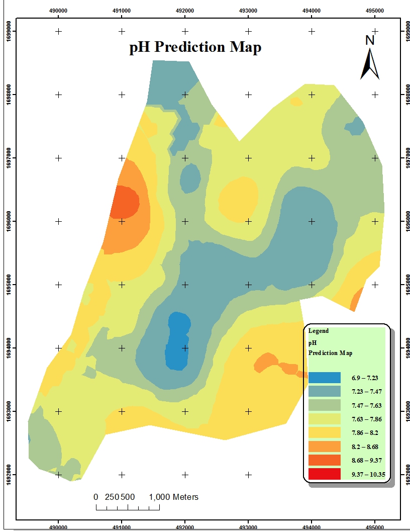
The average predicted values/levels of the physico-chemical parameters of health importance selected for this study i.e. Total Dissolved Solids (TDS), Total Hardness (TH), Chloride (Cl-), Nitrates (NO3-), Calcium (Ca), Magnesium (Mg), Sulphate (SO4) and pH are 791.71mg/L, 569.12mg/L, 124.41mg/L, 64.46mg/L, 155.60mg/L, 46.64mg/L, 159.26mg/L and 7.72 respectively in the study area. The values of the thematic maps could be used to locate new groundwater development sites in terms of water quality. Moreover, the thematic maps can show the trend of spatial distribution of their respective water quality parameters.
Generally, the verification results of the spatial groundwater quality assessments framework developed and applied in this research work shows that the predicted mean values are slightly lower than the actual mean values for almost all the parameters except for Chloride which was depicted to be much lower than its corresponding actual mean value. On the other hand, the predicted TDS mean value shows slightly higher value than its corresponding actual value. The verification of the framework against the actual values demonstrated in Asmara area shows that the framework can be first in type in the country and could be used as a potential prediction framework for spatial groundwater quality assessment in the country with further verification results.
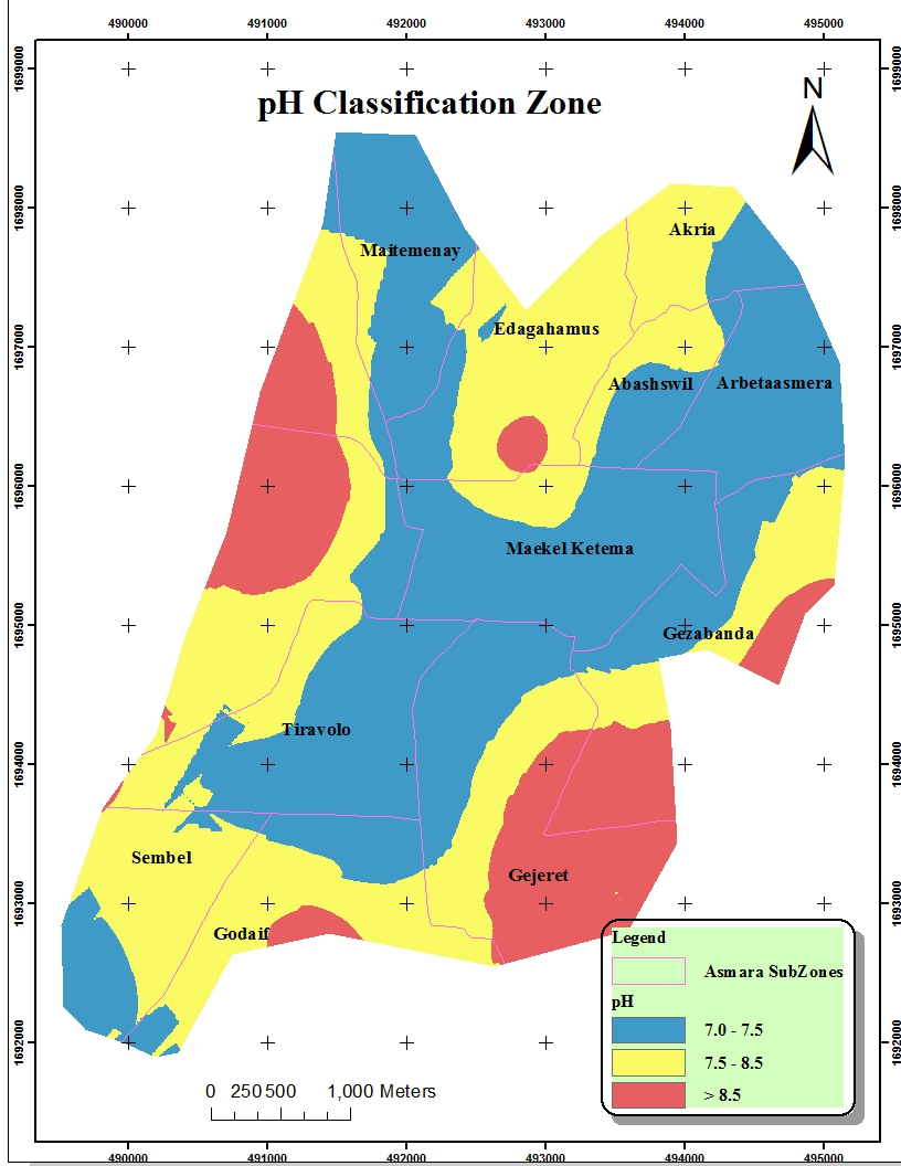
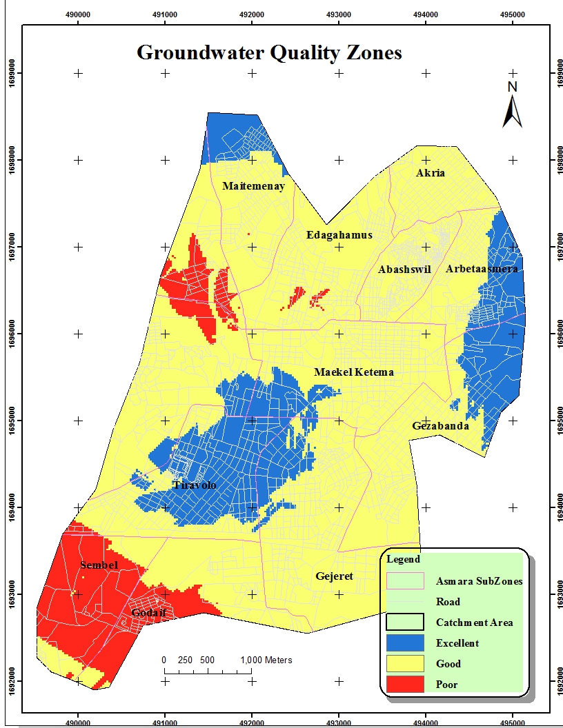
The results of the groundwater quality zone map shows that the potable water without treatment covers about 35.09% (7.79km2) and it is located in the North-West, North- East and at center of the study area. whereas, the potable water in the absence of better alternate sources covers an area of about 57.87% (12.85km2) and it covers majority of the study area. The remaining 7.04% (1.56km2) of the study area falls under non-potable groundwater quality, where it is located in South-West and some part of North-West of the study area. The delineation of groundwater quality zones and establishment of a GIS based database will help decision makers (water resources managers) to monitor and plan the utilization of the groundwater resources in the study area easily.
Finally, future research with the framework should include further testing and analysis of its components on different catchments in the country with enough and spatial distributed datasets. Moreover, it is highly recommended that the framework should have to incorporate temporal datasets to be a full-fledged framework for spatial and temporal prediction of groundwater quality in a given study area (management area).