Abiel Yohannes Weldegiorgis: Urban sprawl analysis and modeling using geo-spatial tools in nu’es zoba Keren, Eritrea
Abstract
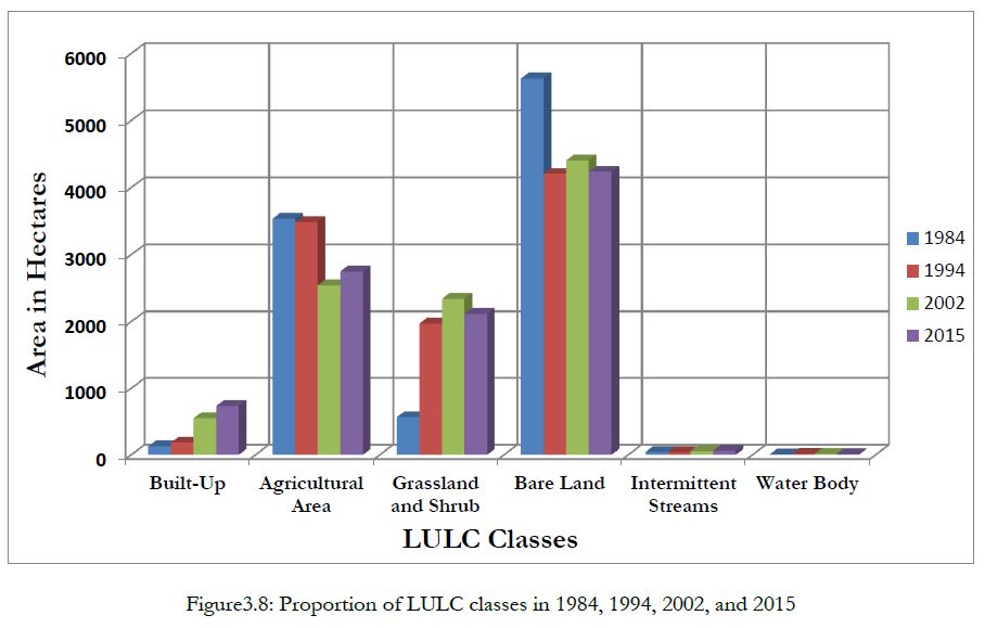
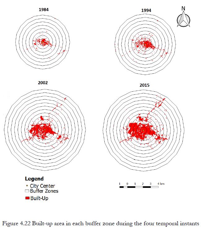
In Nu‘es Zoba Keren, Eritrea, unregulated urbanization coupled with rapid population growth has caused changes in land use and land cover in both the urban and peri-urban areas. Hence, urban sprawl is taking its toll on the natural resources at an alarming pace in the absence of clear urban land use policy in the country. Moreover, little is known about the intensity of simultaneous losses of valuable lands over time caused by urban expansion. Therefore, urbanization pattern of the Nu‘es Zoba from 1984 to 2015 and a prediction for the coming ten years is studied. Thus, the principal objective of this thesis is to utilize satellite data, with the application of geospatial and modeling tools for studying urban land use change. In order to achieve this, satellite data of Landsat TM for 1984 and 1994; ETM+ for 2002 and 2015 were obtained and preprocessed using GRASS GIS 7.0.5. Then, the LULC maps were generated using a pixel-based image classification approach with the Maximum Likelihood algorithm in QGIS 2.18 using the SCP plugin. Classification is assessed using the overall accuracy and Kappa measure of agreement. These measures of accuracies were found to be above minimum standard acceptable level. The land use dynamics, both for pattern and quantities were also studied using a post classification change detection technique together with the following selected spatial/landscape metrics: class area, number of patches, edge density, largest patch index, Euclidian mean nearest neighbor distance, area weighted mean patch fractal dimension, contagion and clumpy. Since, the major concern of the study is urban expansion; the LULC classes were further reclassified into built-up and non-built-up for further analysis. Urban growth has also been measured using statistical models of degree-of-freedom, degree-of-sprawl and degree-of-goodness. Finally, LCM has been used to develop a model, asses the prediction capacity of the developed model and predict future urban land use change. To achieve this, five model variables that explain urban growth and eight land cover transitions were incorporated in the modeling process. Multi-layer perceptron Neural Network has been used to model the transition potential maps, and achieved an acceptable accuracy to make ‘actual’ prediction with Markov Chain Analyst for the year 2025. Results indicated that the built-up area has grown by 473 percent (604 hectares) between 1984 and 2015 and the study area has not experienced ‗goodness‘ in urban growth. The spatial trend of the built up also reveals that there is a growing expansion of the town towards the western part into the dominantly agricultural area of the Megarih plains relative to other directions. Moreover, it is expected that the built-up will grow by 155 percent in 2025 from that of its 2002 size in a way it will continue to expand at the expense of valuable land cover classes. Finally, the outputs of this research provides an objective understanding of the spatio-temporal dynamics of urban land use and land cover changes and its driving factors which is essential to put forward the right policies and monitoring mechanisms on urban growth for decision making.
Key Words: Land use and land cover, Sprawl, GIS, Remote sensing, LCM, Nu‘es Zoba Keren, Eritrea