Mebrahtom Zerom Gebreyesus; Assessment of vulnerability to land degradation using geospatial tools in Tsmieti catchment, nu’es zoba Adi Quala, Eritrea.
Abstract
Land degradation is a major environmental problem in Eritrea, particularly within the highland regions where Tsmieti catchment is found. The heavy dependence of people‟s lives on agriculture and other land-related activities coupled with inappropriate use of environmental resources resulted in rapid and widespread land degradation. On the other hand, development of agricultural sector partly depends on land productivity. However, this resource is seriously threatened by land degradation and aggravates food insecurity problems, posing a direct threat to farmers‟ livelihoods through adverse impacts on crop yields.
Therefore, this study is aimed at assessing the current
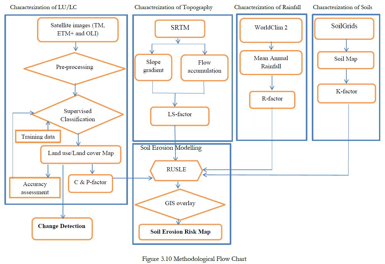
situation of land degradation in Tsmieti catchment, Nués Zoba Adi Quala, based on land use/land cover (LU/LC) change analysis and modelling soil erosion using the Revised Universal Soil Loss Equation (RUSLE). Hence, Landsat images taken at three points in time (1994, 2002, and 2015) are
classified into LU/LC classes using supervised classification techniques by utilizing QGIS2.18.
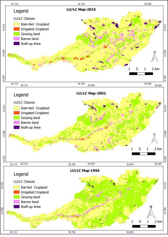
Thereafter, post classification change detection and Normalized Difference Vegetation Index (NDVI) are computed for examining the spatio-temporal changes in the land scenario. The results of LU/LC change detection shows that rain-fed and irrigated croplands, degraded lands and built-up
area are expanding in areal coverage at the expense of grazing land. Accordingly, the statistically computed values reveal that rain-fed cropland, irrigated lands, degraded lands and built-up area show positive percentage change of 49%, 64.8%, 100.2% and 106.6% respectively, while grazing land
declined by 59%. The areal share of degraded land was 296 ha in 1994, 381ha in 2002 and 593ha in 2015. Currently, degraded lands account for 8.8% of the study area, while NDVI image comparisons also indicate major decline in land cover of the study area in the meantime.
Moreover, results of the RUSLE model show annual soil loss of the study area ranges from 0 to 78t/ha/year. These values are categorized into six severity levels of erosion. Of which, the last category, having soil loss above 36t/ha/year, and an area of 679ha (10%) is considered as priority (spot) zone of the study area. A total of 2308ha or 34% of the entire Tsmieti catchment is vulnerable to high, sever and extreme soil loss. Whereas, the remaining areas have soil loss rates less than 11t/ha/year. In addition, grazing lands, followed by degraded land and rain-fed cropland are found to be susceptible to degradation by erosion.
Thus, the findings of the study are necessary for proper conservation intervention and the information is also relevant to the national and international sustainable development goals.
Key words; Land degradation, LU/LC classes, change detection, NDVI, RUSLE, soil loss estimation, Tsmieti catchment, Nués Zoba Adi Quala, Eritrea.