Rakentamassa oppimisen tikapuita kriittiselle geomedian lukutaidolle

Kirjoittajat: Virpi Hirvensalo, Tua Nylén ja Petteri Muukkonen

Tämä blogikirjoitus on julkaistu aiemmin Sirene-verkoston blogissa 17.5.2021 https://www.sirene.fi/blog/rakentamassa-oppimisen-tikapuita-kriittiselle-geomedian-lukutaidolle/.

Lasten ja nuorten kriittisen lukutaidon harjoittelu on nykyään tärkeämpää kuin koskaan aiemmin, jotta he oppivat arvioimaan esimerkiksi internetissä leviävän vaihtelevanlaatuisen tiedon luotettavuutta. Tällainen kriittinen lukutaito on osa monilukutaitoa, jonka tukeminen on yksi perusopetuksen opetussuunnitelman keskeisimpiä tavoitteita. Kriittiseen lukutaitoon kuuluu myös kriittinen geomedian lukutaito. Sillä tarkoitetaan lähde- ja sisältökriittistä tarkastelua sekä analyyttistä otetta karttojen, paikkatiedon sekä paikkaan sidottujen diagrammien, kuvien ja videoiden lukemiseen. Kriittinen geomedian lukutaito kuuluu olennaisena osana maantiedon ja ympäristöopin opetussuunnitelmiin. Myös muissa oppiaineissa, kuten esimerkiksi äidinkielessä, historiassa, yhteiskuntaopissa ja terveystiedossa, harjoitellaan tiedon visualisointia sekä tulkinnan ja lähdekritiikin taitoja. Kyse on siis osin monialaisista taidoista, joiden opettamisessa on mahdollisuus tehdä yhteistyötä tai työnjakoa opettajien välillä, ja joista lapsi hyötyy kaikissa kouluaineissa ja läpi elämän. Mutta kyseessä on myös tieteenalalle tai oppiaineelle ominaisen tiedon esittämisestä ja tulkinnan taidosta. Kriittinen geomedian lukutaito vaatiikin taustalleen myös hyviä geomediataitoja ja maantieteellistä sisältö- ja menetelmäosaamista.

Lasten ja nuorten kriittisen lukutaidon harjoittelu on nykyään tärkeämpää kuin koskaan aiemmin, jotta he oppivat arvioimaan esimerkiksi internetissä leviävän vaihtelevanlaatuisen tiedon luotettavuutta.

Continue reading “Rakentamassa oppimisen tikapuita kriittiselle geomedian lukutaidolle”

Webinaari: Ihmisen kokoista kaupunkia suunnittelemassa: oppeja tutkimuksesta ja liikennesuunnittelun arjesta

Kirjoittajat: Age Poom, Elias Willberg, Tuuli Toivonen

Digital Geography Labin ja Helsingin yliopiston järjestämässä webinaarissa 26.10.2021 pohdittiin, miten luoda miellyttäviä ja terveellisiä liikkumisympäristöjä kaupungeissa.

Webinaarissa esiteltiin tuoreita tutkimustuloksia sekä Helsingin seudun parhaita suunnittelukäytäntöjä. Esitysten aiheina olivat muun muassa liikkumisympäristöjen laatu sekä ihmisten liikkumisenaikainen altistuminen ympäristölle. Webinaarin toisella puoliskolla jatkettiin paneelikeskustelulla, jossa kuultiin näkemyksiä siitä, miten liikennettä ja liikkumisympäristöjä voidaan tutkia ihmisenkokoisesta näkökulmasta sekä siitä, miten ihmisenkokoisuutta voidaan tuoda osaksi kaupunki- ja liikennesuunnittelua.

Continue reading “Webinaari: Ihmisen kokoista kaupunkia suunnittelemassa: oppeja tutkimuksesta ja liikennesuunnittelun arjesta”

OptiSS 🧐 — A tool to optimize spatial joining of social media data

Authors: Bryan Vallejo, Olle Järv

We developed the OptiSS tool to optimize geodetic spatial joining for assigning geographical attributes to social media data in the BORDERSPACE project at the Digital Geography Lab. The tool has a user-friendly local app, yet its Python script can be easily used in any workflow.

Why we developed the tool?

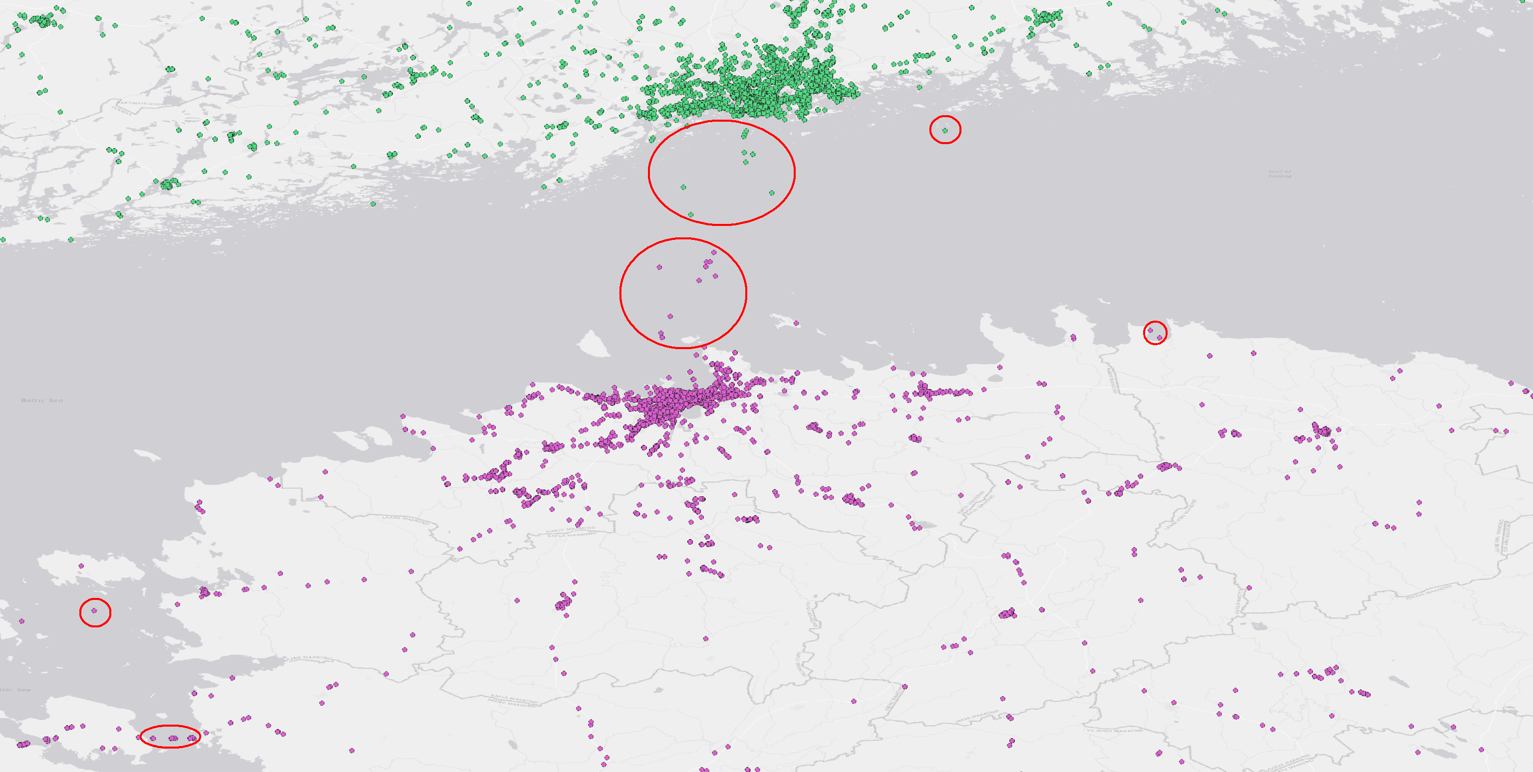
In the BORDERSPACE project, we need to assign hierarchical spatial attributes (municipality, region, country) to each geo-located tweet. Mostly, geo-located tweets obtained from Twitter’s API already have geographical information such as an administrative unit and a country, in addition to exact coordinates. Yet, not all tweets have such information and, most importantly, some tweets are not located on land – some are just off the coast or somewhere at sea (Figure 1). However, geodetic spatial joining requires computational resources and is time consuming, especially when we have 100+ million geo-located tweets to handle. Thus, we created the OptiSS tool to make computation more efficient. The tool works for any social media data that have at least geographical coordinates.

Figure 1. The OptiSS tool assigns geographical attributes like municipality or country efficiently to social media posts. This is useful particularly when posts are not only located on land, but also off the coast (highlighted in red circles). Continue reading “OptiSS 🧐 — A tool to optimize spatial joining of social media data”

New project revealing multi-local living from electricity data has taken off

Authors: Janika Raun, Olle Järv

The Digital Geography Lab is taking part in the MOPA-project (Monipaikkaisen asumisen rytmit, paikat ja asiakasryhmät) to analyse the spatiotemporal patterns of second home use and its users from electricity consumption data. The project is led by the researchers from the Ruralia Institute.

Why and what we study?

The recent Covid-19 pandemic has rapidly increased the number of people spending time and working remotely in their second homes. Thus, second home tourism is increasingly blending with multi-local living – people are residing in several homes and moving often between them. To understand those dynamic changes in mobility patterns new data sources are needed, because the traditional methods cannot fully grasp the rapid changes in second home use, neither provide timeliness information for stakeholders to quickly adopt. During the last decade, mobility studies in general, have widely taken advantage of the use of different big data sets to understand human mobility. However, there is little research carried out that utilizes big data in second home research.

The aim of the MOPA project is to use primarily electricity consumption data to understand the spatiotemporal mobility patterns to second homes and distinguish between different user groups based on the consumption patterns. The data is provided by the electricity company Suur-Sävon Sähko Oy about the South Savo region that is one of the well-known second home hotspots in Finland. We also use aggregated mobile phone data to evaluate how well electricity consumption data properties reveal the presence of people. Continue reading “New project revealing multi-local living from electricity data has taken off”

MSc thesis on capturing the mobility of minority language groups in Finland using Twitter data

Author: Emil Ehnström

Why study the spatial mobility of language minorities?

People are increasingly more mobile that has led to a more complex world. One outcome of this is the linguistic diversification of societies, which has raised the issue of language groups’ integration to a society, but also of their transnationality while people in their new society are still connected to their previous society and culture. One way to understand people’s connectedness to their origin society and integration to their host society is to study their mobility patterns. With novel data sources, like geo-located social media data, it is possible to acquire information on both cross-border and local mobility patterns of language groups.

The three language groups studied in my thesis have different characteristics. Swedish is a national language of Finland and Swedish speakers are generally considered an integral part of Finnish society. Russian speakers have arrived in Finland during multiple time periods, but significantly more since the 1990s during the immigration of the Ingrian-rooted people from the former Soviet Union. Therefore, Russian speakers form a rather heterogeneous language group in Finland. Estonian speakers started moving to Finland since the 1990s and in particular after Estonia joined the EU and the Finnish labour market became more accessible for Estonians. As Estonia and Finland are geographically close, people from Estonia have moved to Finland mainly due to work, while keeping tight connections to Estonia. This has hindered them from fully integrating to the Finnish society. Continue reading “MSc thesis on capturing the mobility of minority language groups in Finland using Twitter data”

Ihmisen kokoista kaupunkia suunnittelemassa webinaari 26.10.2021

Helsingin yliopiston Digital Geography Lab kutsuu lämpimästi sinut osallistumaan Ihmisen kokoista kaupunkia suunnittelemassa: oppeja tutkimuksesta ja liikennesuunnittelun arjesta -webinaariin 26. lokakuuta klo 14:00–16:00.

Webinaari on tarkoitettu niin kaupunki- ja liikennesuunnittelun ammattilaisille, tutkijoille, kuin myös kaikille kaupungeista ja liikenteestä yleisesti kiinnostuneille. Webinaari pidetään pääosin suomeksi.

Webinaari keskittyy pohtimaan, miten luoda miellyttäviä ja terveellisiä liikkumisympäristöjä kaupungeissa. Esittelemme webinaarin alkupuoliskolla tuoreita tutkimustuloksiamme sekä Helsingin seudun parhaita suunnittelukäytäntöjä. Esitysten aiheina ovat muun muassa liikkumisympäristöjen laatu sekä ihmisten liikkumisenaikainen altistuminen ympäristölle. Webinaarin toisella puoliskolla jatkamme paneelikeskustelulla, jossa kuullaan näkemyksiä siitä, miten liikennettä ja liikkumisympäristöjä voidaan tutkia ihmisenkokoisesta näkökulmasta sekä siitä, miten ihmisenkokoisuutta voidaan tuoda osaksi kaupunki- ja liikennesuunnittelua. Myös kaikki tilaisuuden osallistujat voivat ottaa osaa paneelikeskusteluun kysymysten ja kommenttien kautta.

Esittelemme tilaisuudessa myös tuoreen tilaisuuden teemaan kytkeytyvän kirjan “Transport in Human Scale Cities”, jonka ovat toimittaneet Miloš Mladenović, Tuuli Toivonen, Elias Willberg sekä Karst Geurs. Kirja Transport in Human Scale Cities on avoimesti ladattavissa.

Rekisteröidy webinaariin täyttämällä e-lomake 22.10 mennessä. Välitämme osallistumislinkin ilmoittautuneille sähköpostitse webinaaria edeltävänä päivänä. Continue reading “Ihmisen kokoista kaupunkia suunnittelemassa webinaari 26.10.2021”

New open access book out! Transport in Human Scale Cities

We have published a new open access book Transport in Human Scale Cities, which deals with sustainable urban transport

Sustainable urban transport is one of the biggest challenges facing cities worldwide. This means carbon neutrality, but also taking better into account the needs of people and their preferences and needs.  The new book deals exactly with that.

The new book offers fresh perspectives for both practitioners and researchers how to make cities and the transport in them more human-scale in order to meet the demands of the current sustainability crisis and the COVID19 pandemic.

The book provides multidisciplinary perspectives for the development of urban and transport planning processes with a human-scale approach, considering new data and methods and recognizing the diversity of needs of people. We hope that it brings new perspectives to all interested in urban transport. Continue reading “New open access book out! Transport in Human Scale Cities”

Creating knowledge about exercising in the Helsinki Metropolitan Area using Twitter data

Sonja Koivisto introduces her MSc thesis

Why study exercising with social media data?

Sports and exercising are an integral part of a healthy lifestyle. Keeping oneself active is known to prevent obesity and the risk of many chronic diseases. Globally, inactivity is the fourth most common cause of death. The Finnish government has acknowledged the importance of the issue by stating three objectives for encouraging exercise and supporting sports in the current government programme.

There is surprisingly little spatial research about sports in different parts of the Helsinki Metropolitan Area. Only a few sports facilities collect visitors’ statistics and often this information is not openly available. Therefore, I decided to study the topic using social media data. I wanted to find out how people exercise in different parts of the Metropolitan Area and which spatial factors affect the number of sports-related posts.

According to Statistics Finland, 80% of Finns use social media. Among people under 45-years-old, the number is over 95%. People post to social media about topics and activities that are close to their hearts, like sports for instance. The most popular social media platforms in Finland are WhatsApp, Facebook and Instagram. However, these platforms do not share their data for research purposes unlike microblogging platform Twitter. Twitter is used by 10% of Finns. Continue reading “Creating knowledge about exercising in the Helsinki Metropolitan Area using Twitter data”

WE ARE RECRUITING! Looking for a postdoctoral researcher in big data analytics in the area of human mobility and social interactions

Are you interested in studying human mobility and social interactions that take place in the cross-border context, and doing advanced spatial and content analysis using millions of social media posts? If so, consider applying for a postdoc position at the Digital Geography Lab (DGL) to work with Academy Research Fellow Olle Järv from November 2021 (or sooner/later as agreed)!

We are looking for an enthusiastic, innovative, and open-minded team player with strong technical knowledge and skills to join our interdisciplinary DGL research group and work in the Academy of Finland-funded project BORDERSPACE – Tracing Interactions and Mobilities Beyond State Borders: Towards New Transnational Spaces. Continue reading “WE ARE RECRUITING! Looking for a postdoctoral researcher in big data analytics in the area of human mobility and social interactions”

Understanding functional cross-border regions from Twitter data: The Nordics case study

Håvard Wallin Aagesen introduces his MSc thesis

How can Twitter data be used to study cross-border regions in the Nordics? And how are the effects of the COVID-19 pandemic reflected in the spatial pattern of Twitter usage? These were some of the questions that Håvard Wallin Aagesen, a fresh PhD candidate at the Digital Geography Lab, addressed in his MSc thesis “Understanding Functional Cross-border Regions from Twitter Data in the Nordics“. In this blog post, Håvard looks back to and summarizes his MSc work.

Why this matters?

As part of the BORDERSPACE project, I set out to investigate how cross-border interactions in the Nordic countries can be studied, using Big Data from Twitter. In light of the COVID-19 pandemic, a newfound need for studying cross-border flows has arisen, and Twitter data could provide the possibility to quickly and easily explore the changes in human mobility patterns before and during the pandemic.

The Nordic region is a connected region with a long history of cooperation, shared cultures, and social and economic interactions. Cross-border cooperation and cross-border mobility has been a central aspect in the region for over half a century. Despite of shared borders and all countries being part of the Schengen Area, allowing free movement, little research has been made on the extent of daily cross-border movements and little data exist on the topic.

Continue reading “Understanding functional cross-border regions from Twitter data: The Nordics case study”