Creating knowledge about exercising in the Helsinki Metropolitan Area using Twitter data

Sonja Koivisto introduces her MSc thesis

Why study exercising with social media data?

Sports and exercising are an integral part of a healthy lifestyle. Keeping oneself active is known to prevent obesity and the risk of many chronic diseases. Globally, inactivity is the fourth most common cause of death. The Finnish government has acknowledged the importance of the issue by stating three objectives for encouraging exercise and supporting sports in the current government programme.

There is surprisingly little spatial research about sports in different parts of the Helsinki Metropolitan Area. Only a few sports facilities collect visitors’ statistics and often this information is not openly available. Therefore, I decided to study the topic using social media data. I wanted to find out how people exercise in different parts of the Metropolitan Area and which spatial factors affect the number of sports-related posts.

According to Statistics Finland, 80% of Finns use social media. Among people under 45-years-old, the number is over 95%. People post to social media about topics and activities that are close to their hearts, like sports for instance. The most popular social media platforms in Finland are WhatsApp, Facebook and Instagram. However, these platforms do not share their data for research purposes unlike microblogging platform Twitter. Twitter is used by 10% of Finns. Continue reading “Creating knowledge about exercising in the Helsinki Metropolitan Area using Twitter data”

WE ARE RECRUITING! Looking for a postdoctoral researcher in big data analytics in the area of human mobility and social interactions

Are you interested in studying human mobility and social interactions that take place in the cross-border context, and doing advanced spatial and content analysis using millions of social media posts? If so, consider applying for a postdoc position at the Digital Geography Lab (DGL) to work with Academy Research Fellow Olle Järv from November 2021 (or sooner/later as agreed)!

We are looking for an enthusiastic, innovative, and open-minded team player with strong technical knowledge and skills to join our interdisciplinary DGL research group and work in the Academy of Finland-funded project BORDERSPACE – Tracing Interactions and Mobilities Beyond State Borders: Towards New Transnational Spaces. Continue reading “WE ARE RECRUITING! Looking for a postdoctoral researcher in big data analytics in the area of human mobility and social interactions”

Understanding functional cross-border regions from Twitter data: The Nordics case study

Håvard Wallin Aagesen introduces his MSc thesis

How can Twitter data be used to study cross-border regions in the Nordics? And how are the effects of the COVID-19 pandemic reflected in the spatial pattern of Twitter usage? These were some of the questions that Håvard Wallin Aagesen, a fresh PhD candidate at the Digital Geography Lab, addressed in his MSc thesis “Understanding Functional Cross-border Regions from Twitter Data in the Nordics“. In this blog post, Håvard looks back to and summarizes his MSc work.

Why this matters?

As part of the BORDERSPACE project, I set out to investigate how cross-border interactions in the Nordic countries can be studied, using Big Data from Twitter. In light of the COVID-19 pandemic, a newfound need for studying cross-border flows has arisen, and Twitter data could provide the possibility to quickly and easily explore the changes in human mobility patterns before and during the pandemic.

The Nordic region is a connected region with a long history of cooperation, shared cultures, and social and economic interactions. Cross-border cooperation and cross-border mobility has been a central aspect in the region for over half a century. Despite of shared borders and all countries being part of the Schengen Area, allowing free movement, little research has been made on the extent of daily cross-border movements and little data exist on the topic.

Continue reading “Understanding functional cross-border regions from Twitter data: The Nordics case study”

New paper out! Environmental exposure during travel: A research review and suggestions forward

Age Poom, Elias Willberg, Tuuli Toivonen

Our seminal research review paper on environmental exposures during travel is now published in the journal Health & Place! https://doi.org/10.1016/j.healthplace.2021.102584 

Urban travel environments exposure people to a range of environmental conditions, such as traffic noise, air pollution or street-level greenery. These exposures may cause both positive and negative health and wellbeing consequences. Knowledge of the dynamics of environmental exposures during travel, and their social and health outcomes would help improve the liveability and sustainability of our cities through evidence-based transport and urban planning.

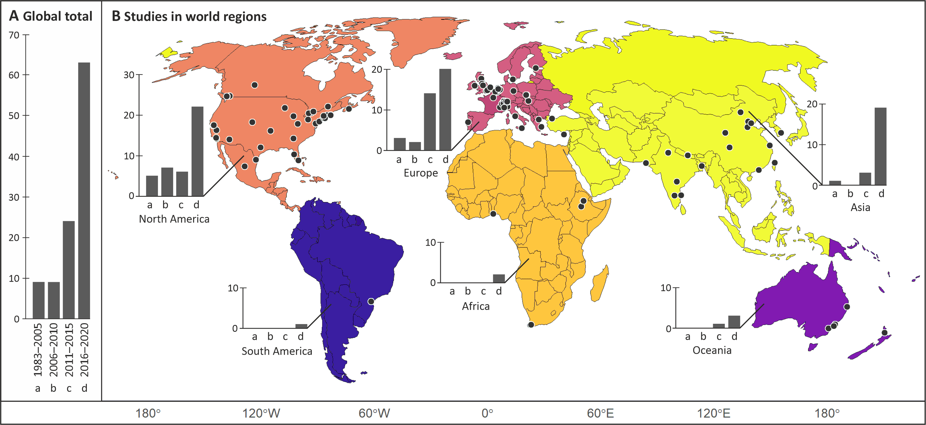
We conducted a systematic review of the scholarly literature on environmental exposure during travel. We aimed to understand the state of the art of the research field and identify areas for further studies. We identified 104 relevant peer-reviewed journal articles worldwide. The research field is clearly emerging with increasing number of studies published each year. The distribution of the study areas indicates a global bias in the research field towards western cities, where the research tradition is longer. However, last years have witnessed a rapid increase in the number of studies conducted in China and India. A good global coverage of research supports local planning and governance, and better mitigates the risk of environmental health disparities in all parts of the world.

The number of studies published globally in different year ranges (A), and the spatial distribution of studies in different world regions using the same year ranges for the bars (B). The locations of individual study sites are indicated as points on the map (B). Source: Poom et al. 2021

Continue reading “New paper out! Environmental exposure during travel: A research review and suggestions forward”

Warm reflections from the course GEOG-326 on accessibility and human mobility research

Time flies – the course “GEOG-326 Quantitative methods for sustainable land use planning I: Accessibility & mobility analyses“, given by the researchers of the Digital Geography Lab, ended already before Christmas 2020. Yet it’s worthwhile to reflect on it!

It is heart-warming to go through the positive feedback from students regarding the course structure and balance between theory and practice, and constructive suggestions for improving the course.

The course aimed at linking the accessibility and mobility of people to sustainability, well-being and social (in)equality perspectives, exploring the potential of big data analysis approach, and studying the ways of implementing these in planning. We also focused on the impact of global crises on human mobility on the example of COVID-19.

Overall, all 35 students did a great job and received high grades, but most importantly, it was rewarding to see students getting motivated and inspired, and developing their skills and ideas during the course.

The final output of the course was an independent group work that was presented in the form of an academic poster. Me, Elias and Tuuli found the final poster presentation session excellent! Thus, we are delighted to share the posters here 🙂

Check out and get inspired!

Continue reading “Warm reflections from the course GEOG-326 on accessibility and human mobility research”

Etsimme tutkijatohtoria tai tohtorikoulutettavaa!

Briefly in English: We are sharing an announcement for a post-doc/PhD student position at Digital Geography Lab and Ruralia Institute. The position benefits from the knowledge of Finnish language and hence is published in Finnish only.

Ja sitten suomeksi:

Kiinnostaako monipaikkaisuus, aluekehitys ja ihmisten liikkuvuus? Haluaisitko tietää, miten erilaisten digitaalisten aineistojen avulla voi monipaikkaisuutta tarkastella tai miten COVID-19 pandemia on vaikuttanut kakkosasuntojen käyttöä Suomessa?

Ruralia-instituutti ja Digital Geography Lab yhteiistyössä hakee tutkijatohtoria/tohtorikoulutettavaa hankkeeseen ”Monipaikkaisen asumisen rytmit”.

Tehtävät käsittävät digitaalisten massa-aineistojen (mm. rakennusten sähkönkäytön, matkapuhelinverkon ja Twitter aineistoja) hallinnointia, prosessointia ja analysointia. Hakijalta edellytetään riittäviä geoinformatiikan taitoja analyysien tekoon, massa-aineistojen käsittelyyn vaativaa osaamista (Python, R, PostgreSQL) ja tilastollista osaamista. Suurteholaskennan kokemus katsotaan eduksi.

Tarkemmat hakuohjeet löytyvät täältä.

Hakuaika päättyy 22.3.2021, ole nopea!

Lisätietoja saa: akatemiatutkija Olle Järv olle.jarv(at)helsinki.fi ja professori Tuuli Toivonen, tuuli.toivonen(at)helsinki.fi

Two new papers out on cycling!

We have published two new articles on cycling! 

What do trip data reveal about bike-sharing system users‘ was published in Journal of Transport Geography.

Highlights:

    • As cities strive to foster cycling, bike-sharing systems (BSS) have become increasingly common.
    • We used bike-sharing trip data from Helsinki and looked at user profiles and usage patterns. We also focused on the possibilities of BSS trip data.
    • The bike-sharing system in Helsinki has been actively used even in international comparison, but our results point toward challenges in BSS inclusivity in Helsinki in 2017. Most use was contributed by a limited group of ‘super-users’.
    • BSS trip data provides opportunities to understanding BSS user profiles & patterns. By being well available, unlike many other cycling data sources, and automatically collected, trip data can save resources, facilitates longitudinal research and reveals observed behaviour.

Willberg E., Salonen M., Toivonen T. (2021). What do trip data reveal about bike-sharing system users? Journal of Transport Geography. https://www.sciencedirect.com/science/article/pii/S0966692321000247

Continue reading “Two new papers out on cycling!”

WE ARE RECRUITING! Doctoral student with an interest in Big Data analytics, human mobility & social interaction

Are you interested in geoinformatics, big data and social media analytics? Are you curious about the phenomena of human mobility, cross-border mobilities and social interactions of people and transnational people? If yes, check this open four-year doctoral student position at the Digital Geography Lab starting from March 2021 or as agreed with the selected applicant!

We are looking for an enthusiastic, innovative, and highly motivated doctoral student with strong technical knowledge and skills to join our interdisciplinary research group Digital Geography Lab and work in the Academy of Finland-funded project BORDERSPACE – Tracing Interactions and Mobilities Beyond State Borders: Towards New Transnational Spaces.

The doctoral project has three objectives. First, to develop methodologies for quantifying human mobility and activity spaces across country borders based on social media data (Twitter). Second, to develop quantitative methodologies for uncovering activity practices of social media users and their feeling of belonging based on the content of their social media posts. Third, to conduct critical research on dynamic cross-border mobility flows derived from big data, integration of transnational people through their cross-border mobilities and social interactions, and how these are influenced by external factors such as the COVID-19 pandemic.

The successful applicant is expected to have strong fluency in programming (Python or R), experience in advanced spatial analytics and/or social media content analysis, and has worked with big data sources such as mobile phone, smart card and social media data. Prior experience in publishing research in academic journals, participating in research community and having a network of international scholars is an asset.

Read more about the position announcement and apply HERE. The deadline is January 31st 2021.

For further information, please contact Academy Research Fellow Olle Järv, olle.jarv(at)helsinki.fi.

Vuokko’s lectio 9.12.2020

User-generated Geographic Information for Understanding Human Activities in Nature

Lectio Praecursoria, in the public examination of MSc Vuokko Heikinheimo’s doctoral dissertation
the 9th of December 2020


Nature contributes to human well-being in countless ways. Many of us enjoy spending time in nature, going for a walk or a picnic and observing species and seasons. Nature-based tourism and outdoor recreation are evident examples of direct benefits of nature to people.

National parks are protected areas that are dedicated to safeguarding biodiversity and providing people the opportunity to enjoy nature.

Urban green spaces include the network of parks, forests and other green areas in the urban structure. Green spaces in cities offer opportunities for contact to nature in our everyday lives while protecting urban biodiversity.

We are also willing to travel far in order to experience and enjoy nature. In many places, visitors of protected areas – both domestic and international – are a significant source of income for park management and local communities. Information about protected area visitors is important for planning and management on regional, national and international scales.

The ongoing pandemic has emphasized the importance of access to green spaces in everyday life.

Continue reading “Vuokko’s lectio 9.12.2020”

Inaugural lecture by Professor Toivonen

Tuuli Toivonen is now a full professor in geoinformatics at the Faculty of Science!

Newly appointed  professors at the University of Helsinki are celebrated twice a year. As part of these celebrations, the professors hold an inaugural lecture.  This autumn, all festivities were (understandably) held online which allowed everyone interested to watch these lessons online.You can watch Tuuli’s lecture in here (Finnish audio, Finnish and English subtitles available):

Congrats once more to Tuuli!