This is the second post of three in series called Changing Sugar Island: A Study of Twentieth-Century Finnish American Settlement. Look for the other two posts in the menu above.
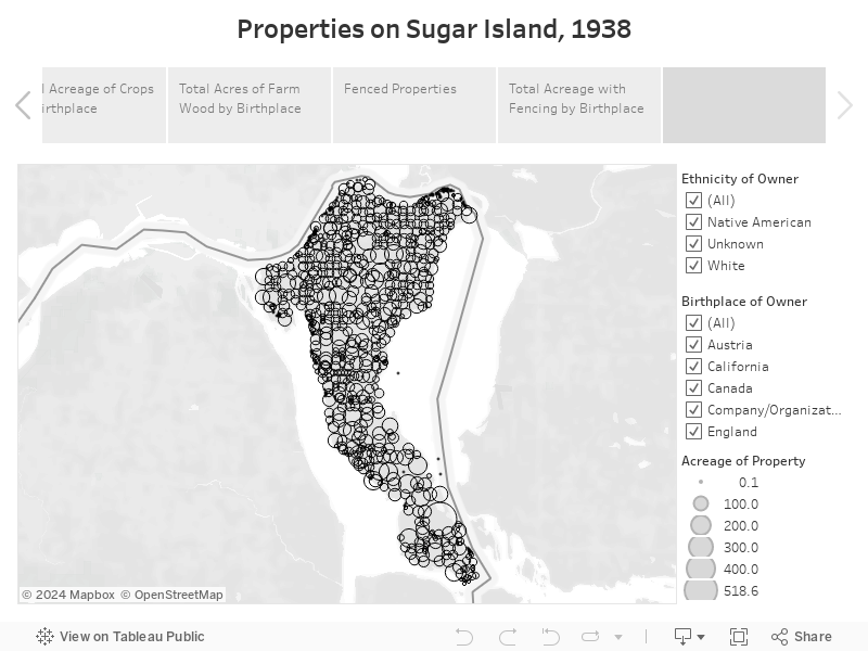
For the second of three blog posts about Finnish American migrants to Sugar Island, Michigan and their use of the land, I will focus on all of the island’s property owners in 1938, how much land was occupied, how much was used for farming, and how many barns, granaries, and warehouses were constructed by the Finnish-Americans and other residents.
As I mentioned in our previous post, the series of maps, charts, and visualizations presented here were derived from data collected by the Works Progress Administration’s Rural Property Inventory, property records, and census data. The maps are interactive, so you can zoom in/out and filter what is displayed.
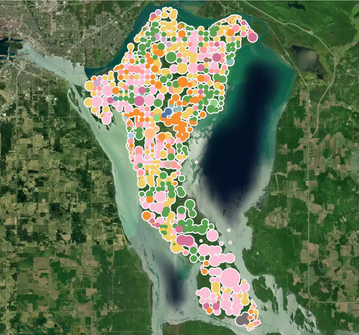
The map below visualizes every plot that was inventoried on Sugar Island by the WPA in 1938 (click here for the full-screen view). Each colored circle represents a plot, and the size of the circle represents the acreage. You can see the name of the plot owner, their birthplace, the size of the property, the geolocation (in both township/range/section and latitude/longitude) information about the buildings that were on the plot, and some information about the plot owner (if available) sourced from the 1940 U.S. Census (such as their occupation or marital status). Play with the filters on the right side of the map – you can view just the Native American property owners or the just the Finns. Government lands are in pink (businesses are dark pink), you will see a lot of pink, and Finnish American owned land is the darker green. Notice the pockets of Finnish settlement. You can view a spreadsheet in the second slide that lists the plot owner, their ‘race’ and birthplace (which was determined by census data and other sources), the number of plots they owned, and the total acreage of all of their plots.
The second map gives some insight on which 1938 property owners were permanent residents on Sugar Island and those who had permanent residents elsewhere, like vacationers or snowbirds. The property owners in green appear on the Sugar Island census in 1940, those in red do not. Because the 1938 WPA inventory does not indicate if the property owner resided on the property, I use the 1940 census to determine residency. Of course, some folks who do not appear on the 1940 census may have just moved off Sugar Island after the 1938 WPA inventory. But, you’ll notice that there are a lot of smaller red dots along the coastline (zoom in), indicating that many of the owners who had small plots along the water used their properties for vacationing.

The next slide is a visualization of total land ownership by birthplace. As I mentioned in the previous blog post, from 1915 to 1939, Finnish-born Americans acquired a disproportionate amount of land on Sugar Island. Out of the 437 property owners on Sugar Island in 1938 (not including properties owned by businesses and governments), 98 of them were Finnish-born (22.4% of the population), but those 98 Finns owned 6,322 of the 21,581 acres inventoried, or 29.3%.

By the end of the 1930s, most residents of Sugar Island still made their living as farmers, as you can see on the map below, which shows the occupation of property owners (from the 1938 inventory) who appear in the 1940 census (click here for the full-screen view, you can click on the left and right arrows to see additional visualizations of Sugar Island demographics).

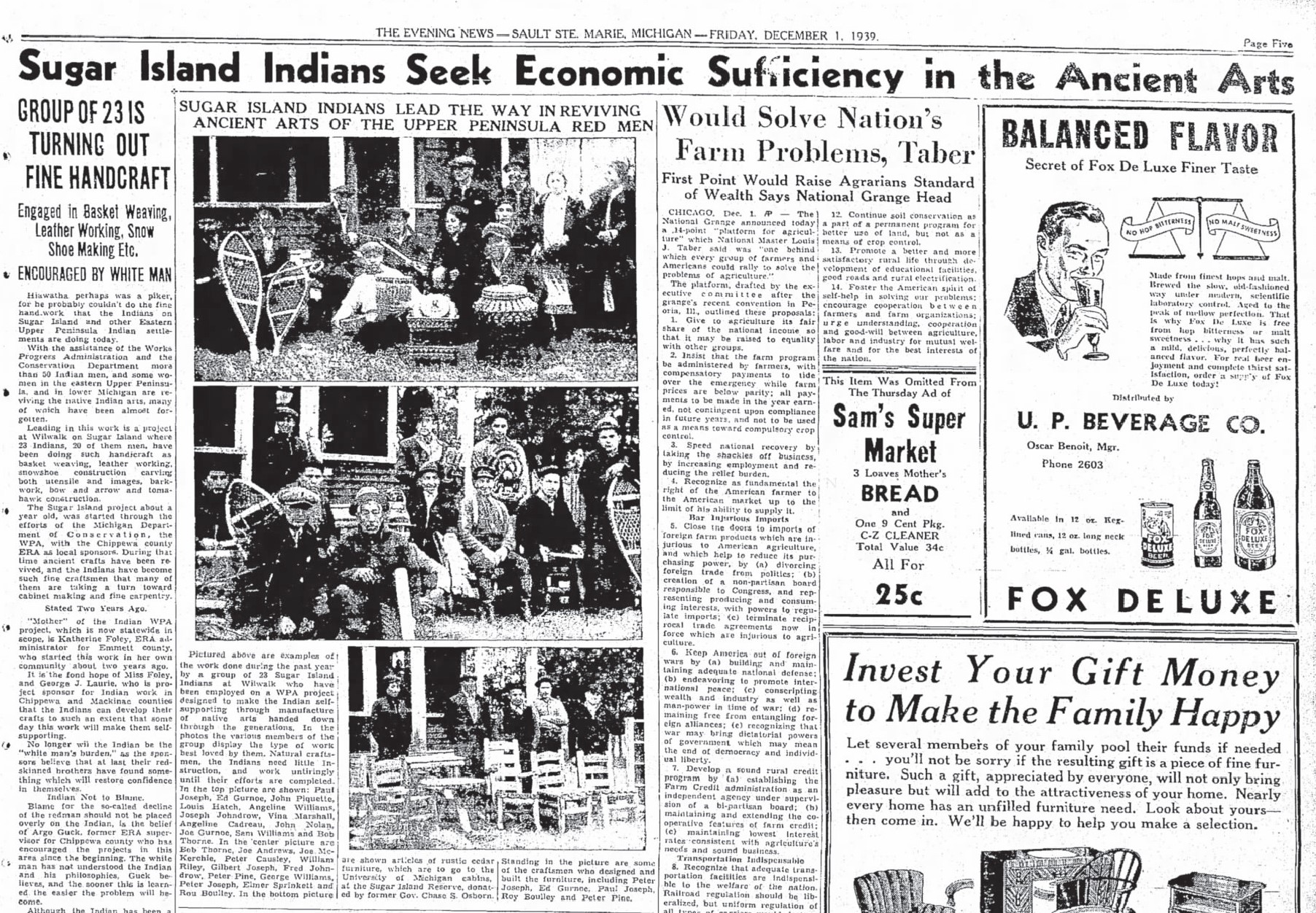
The island’s Anishinaabe (Chippewa or Ojibwe) population was not engaged in large-scale farming, at least not as owners of that farm acreage. Of the 4,672 acres that were being farmed in 1938, only 100 acres were owned by people of Native ancestry. Some Anishinaabe were wage laborers in the 1930s, either on farms or in the forests cutting timber. Others harvested and processed maple syrup (a centuries-old practice, which is why the island was known as ‘Sugar Island’) and a growing number made and sold arts and crafts, especially hand-woven baskets. The WPA started a project meant to encourage Indian “handicrafts” and help find a market for those products. It is important to remember that the island’s residents were enduring the Great Depression during the 1930s, like most Americans.
Most of the Finnish American population started farms, many having to clear forests as they arrived to make their fields. By 1938, Finnish fields were producing most of the food on Sugar Island.
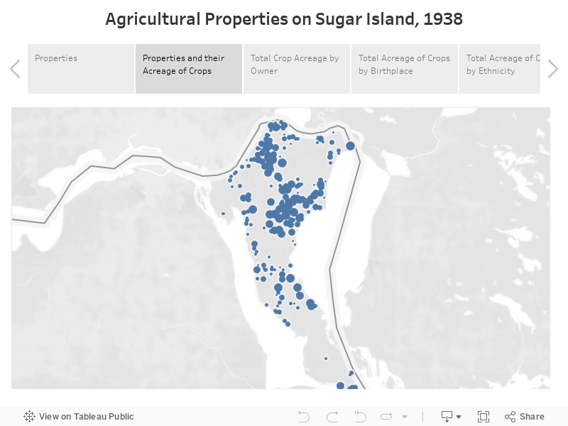
The map below shows where crops were being grown in 1938 – the larger the circle, the larger the farm. If you hover your pointer over a circle, you will see a tooltip that offers details about that property, including the agricultural buildings on it.
The next slide shows the total acreage of crops being farmed by birthplace. By 1938, Finnish Americans were farming more acreage than both the American-born and Canadian born residents of the island (1,606 of the 4,520 acres of cropland were owned by Finns, or 35.5%).

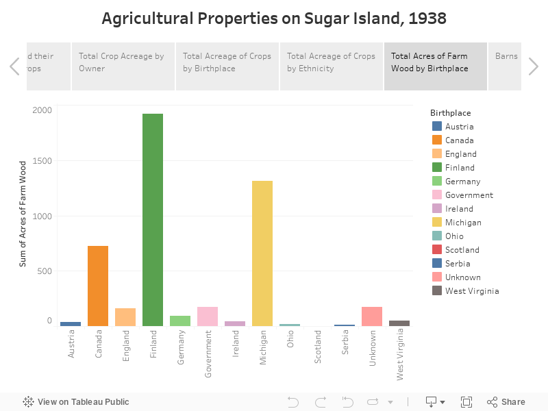
Finns also overwhelmingly harvested more timber on their properties than any other group, demonstrated on the bar graph below.
Below is a spreadsheet that lists the total amount of crop acreage owned by individual.

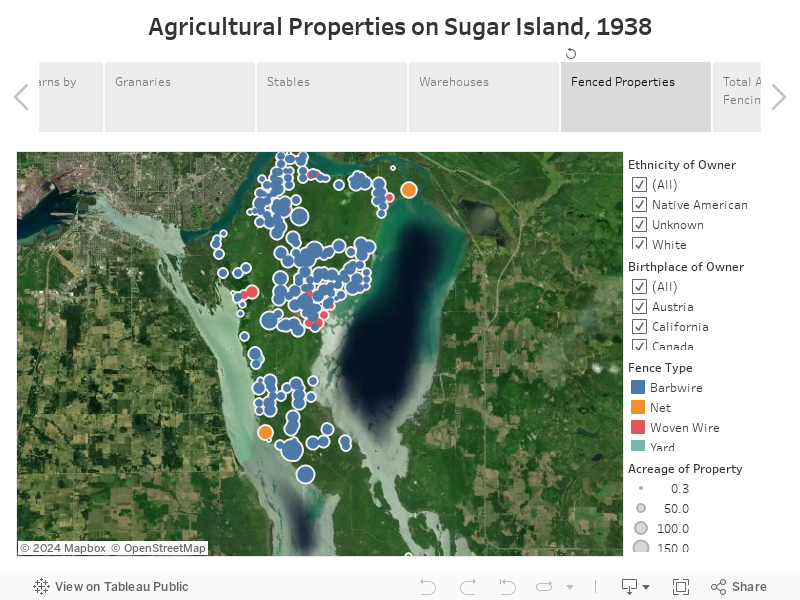
The 1938 WPA inventory also noted the properties that were fenced, or had fencing somewhere, and the type of fencing that was used. Finns fenced in their lands at a higher rate than both the American-born and Canadian-born residents. Take a look at the map below and the bar graph on the next slide (the inventory did not estimate the total length of fencing on each property or how much acreage was “fenced-in”). This fencing suggests that Finns were more likely to have domesticated animals on their properties (dairy cows in particular). Finns also had more fencing because they had more crops that needed to be protected from animals.
Finns also owned nearly half of all the barns on Sugar Island by 1938. See the map of barns below and the number of barns owned by birthplace on the following slide.

I’ve also mapped the granaries, stables, and warehouses that were built on Sugar Island, according to the 1938 inventory.

Although it is not clear how many acres of forest were cleared by Finnish settlers or the exact length of fencing they constructed, the Finns worked to change the island’s landscape to make it suitable for farming. These changes included the construction of roads, which increased dramatically because of the political influence of the Finnish settlers.
The third and final blog post in this series will focus on the homes built on Sugar Island.