Webinaari: Ihmisen kokoista kaupunkia suunnittelemassa: oppeja tutkimuksesta ja liikennesuunnittelun arjesta

Kirjoittajat: Age Poom, Elias Willberg, Tuuli Toivonen

Digital Geography Labin ja Helsingin yliopiston järjestämässä webinaarissa 26.10.2021 pohdittiin, miten luoda miellyttäviä ja terveellisiä liikkumisympäristöjä kaupungeissa.

Webinaarissa esiteltiin tuoreita tutkimustuloksia sekä Helsingin seudun parhaita suunnittelukäytäntöjä. Esitysten aiheina olivat muun muassa liikkumisympäristöjen laatu sekä ihmisten liikkumisenaikainen altistuminen ympäristölle. Webinaarin toisella puoliskolla jatkettiin paneelikeskustelulla, jossa kuultiin näkemyksiä siitä, miten liikennettä ja liikkumisympäristöjä voidaan tutkia ihmisenkokoisesta näkökulmasta sekä siitä, miten ihmisenkokoisuutta voidaan tuoda osaksi kaupunki- ja liikennesuunnittelua.

Continue reading “Webinaari: Ihmisen kokoista kaupunkia suunnittelemassa: oppeja tutkimuksesta ja liikennesuunnittelun arjesta”

Ihmisen kokoista kaupunkia suunnittelemassa webinaari 26.10.2021

Helsingin yliopiston Digital Geography Lab kutsuu lämpimästi sinut osallistumaan Ihmisen kokoista kaupunkia suunnittelemassa: oppeja tutkimuksesta ja liikennesuunnittelun arjesta -webinaariin 26. lokakuuta klo 14:00–16:00.

Webinaari on tarkoitettu niin kaupunki- ja liikennesuunnittelun ammattilaisille, tutkijoille, kuin myös kaikille kaupungeista ja liikenteestä yleisesti kiinnostuneille. Webinaari pidetään pääosin suomeksi.

Webinaari keskittyy pohtimaan, miten luoda miellyttäviä ja terveellisiä liikkumisympäristöjä kaupungeissa. Esittelemme webinaarin alkupuoliskolla tuoreita tutkimustuloksiamme sekä Helsingin seudun parhaita suunnittelukäytäntöjä. Esitysten aiheina ovat muun muassa liikkumisympäristöjen laatu sekä ihmisten liikkumisenaikainen altistuminen ympäristölle. Webinaarin toisella puoliskolla jatkamme paneelikeskustelulla, jossa kuullaan näkemyksiä siitä, miten liikennettä ja liikkumisympäristöjä voidaan tutkia ihmisenkokoisesta näkökulmasta sekä siitä, miten ihmisenkokoisuutta voidaan tuoda osaksi kaupunki- ja liikennesuunnittelua. Myös kaikki tilaisuuden osallistujat voivat ottaa osaa paneelikeskusteluun kysymysten ja kommenttien kautta.
Esittelemme tilaisuudessa myös tuoreen tilaisuuden teemaan kytkeytyvän kirjan “Transport in Human Scale Cities”, jonka ovat toimittaneet Miloš Mladenović, Tuuli Toivonen, Elias Willberg sekä Karst Geurs. Kirja Transport in Human Scale Cities on avoimesti ladattavissa.

Rekisteröidy webinaariin täyttämällä e-lomake 22.10 mennessä. Välitämme osallistumislinkin ilmoittautuneille sähköpostitse webinaaria edeltävänä päivänä. Continue reading “Ihmisen kokoista kaupunkia suunnittelemassa webinaari 26.10.2021”

New paper out! Environmental exposure during travel: A research review and suggestions forward

Age Poom, Elias Willberg, Tuuli Toivonen

Our seminal research review paper on environmental exposures during travel is now published in the journal Health & Place! https://doi.org/10.1016/j.healthplace.2021.102584 

Urban travel environments exposure people to a range of environmental conditions, such as traffic noise, air pollution or street-level greenery. These exposures may cause both positive and negative health and wellbeing consequences. Knowledge of the dynamics of environmental exposures during travel, and their social and health outcomes would help improve the liveability and sustainability of our cities through evidence-based transport and urban planning.

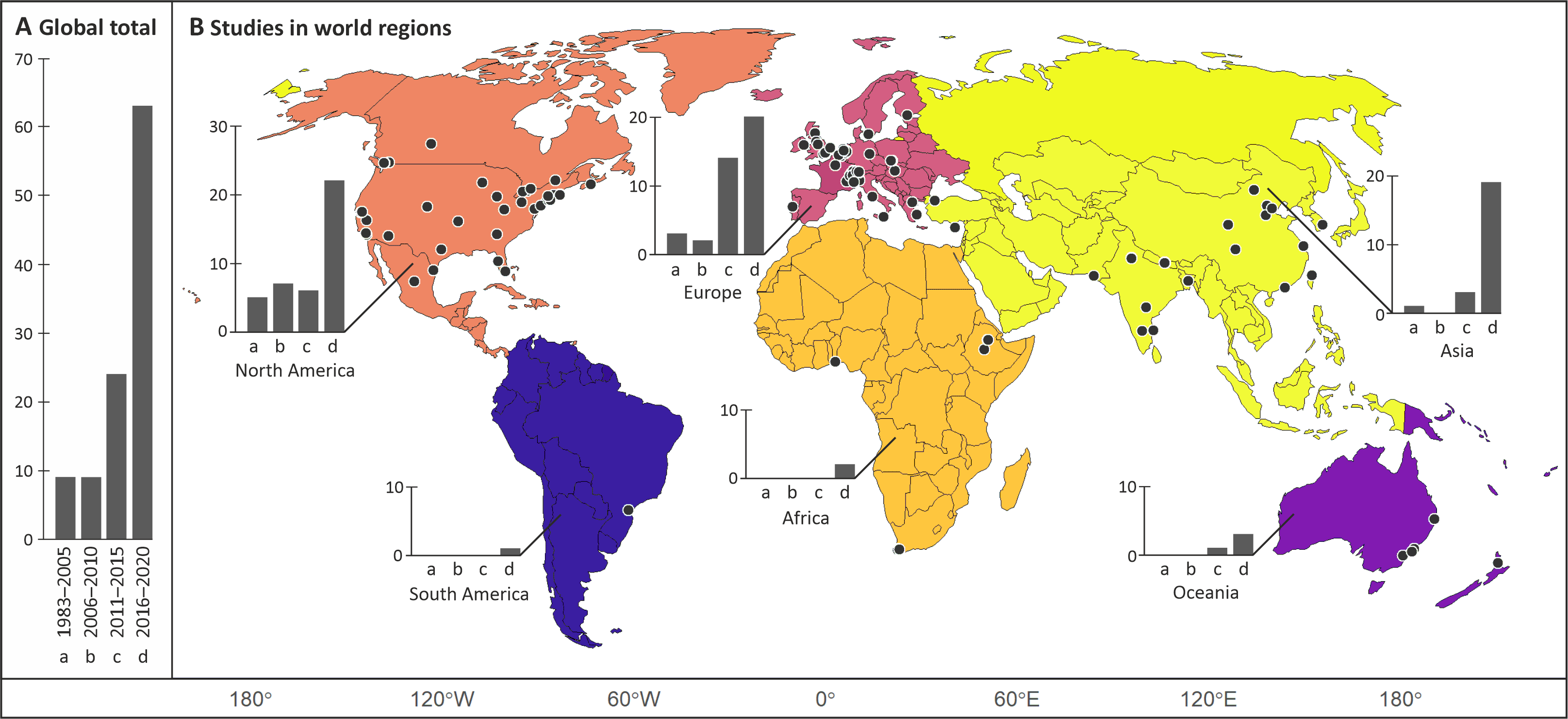
We conducted a systematic review of the scholarly literature on environmental exposure during travel. We aimed to understand the state of the art of the research field and identify areas for further studies. We identified 104 relevant peer-reviewed journal articles worldwide. The research field is clearly emerging with increasing number of studies published each year. The distribution of the study areas indicates a global bias in the research field towards western cities, where the research tradition is longer. However, last years have witnessed a rapid increase in the number of studies conducted in China and India. A good global coverage of research supports local planning and governance, and better mitigates the risk of environmental health disparities in all parts of the world.

The number of studies published globally in different year ranges (A), and the spatial distribution of studies in different world regions using the same year ranges for the bars (B). The locations of individual study sites are indicated as points on the map (B). Source: Poom et al. 2021

Continue reading “New paper out! Environmental exposure during travel: A research review and suggestions forward”

Green Paths -reittiopas edistää terveellistä ja aktiivista matkustamista

Age Poom, Joose Helle, Tuuli Toivonen

Uusi Green Paths -reittiopas auttaa valitsemaan hiljaisemman ja ilmanlaadultaan parhaan pyöräily- ja kävelyreitin.

Pääkaupunkiseudulla toimivan reittityökalun suositukset perustuvat reaaliaikaiseen tietoon ilmanlaadusta sekä kaupungilla tehtyihin melutasomittauksiin. Sovelluksen avulla liikkuja välttää vilkkaasti liikennöidyt kadut, mutta pääsee silti perille kohtuullisessa ajassa.

Helsingin yliopiston Digital Geography Lab -tutkimusryhmä on kehittänyt Green Paths -reittityökalun auttamaan jalankulkijoita ja pyöräilijöitä löytämään miellyttävimmät reitit. Nyt julkistettu sovellus on prototyyppi, joka toimii Helsingin, Espoon, Vantaan ja Kauniaisten alueella.  Näissä kunnissa on saatavilla sovelluksen tarvitsemaa dataa.

Yleensä reittioppaat tarjoavat nopeimpia tai lyhimpiä reittejä, mutta miellyttävyyttä ja terveellisyyttä ei huomioida. Ohjaamalla pyöräilijät ja kävelijät miellyttävämpään matkaympäristöön reittiopas pyrkii edistämään kaupunkiliikkujien terveyttä ja hyvinvointia. Tutkimusryhmämme toivoo reittioppaan edistävän myös ilmastollisesti vastuullista ja kestävää kaupunkiliikennettä.

Continue reading “Green Paths -reittiopas edistää terveellistä ja aktiivista matkustamista”

Green Paths routing tool encourages healthy and active travelling

Authors: Age Poom, Joose Helle, Tuuli Toivonen

The new Green Paths routing tool helps pedestrians and cyclists to choose urban commuting routes with less air and noise pollution. The tool is a proof of concept of exposure-optimised routing. It functions in the Helsinki capital region where the necessary environmental data is available.

This novel routing tool suggests a set of routes to the user-defined destination that are less polluted than the shortest, often busy main road. This is different from the traditional routing concept that considers only distance or travel time for route choices.

The users of the Green Paths routing tool can follow their own preferences in making the final route choice that is quieter, has fresher air and feels more pleasant. As such, the user becomes an active decision-maker, empowered to choose the most appealing route with only a modest increase in travel time. The new Green Paths routing tool indeed aims to improve travel satisfaction. A pleasant travel experience makes commuters more likely to walk or cycle regularly. In this way, commuters using the Green Paths tool contribute to a more sustainable city with cleaner air.

Continue reading “Green Paths routing tool encourages healthy and active travelling”

COVID-19 is spatial: Ensuring that mobile Big Data is used for social good

Authors: Age Poom, Olle Järv, Matthew Zook and Tuuli Toivonen

We have just published our commentary regarding human mobility, mobile Big Data and the responses to COVID-19 pandemic in the Big Data & Society journal (see also the journal’s blog).

This commentary was motivated by our previous experience with mobile Big Data and recent work on changed human mobility derived from mobile phone data during the COVID-19 outbreak in Finland (e.g. Järv et al. 2020a; Järv etal. 2020b). It also draws from the knowledge and experiences of our peers around the globe.

In short, the mobility restrictions related to COVID-19 pandemic have resulted in the biggest disruption to individual mobilities in modern times. The crisis is clearly spatial in nature, and examining the geographical aspect is important in understanding the broad implications of the pandemic. We can benefit from the avalanche of mobile Big Data that makes it possible to study the spatial effects of the crisis with spatiotemporal detail at the national and global scales. Yet, the current crisis also highlights serious limitations in the readiness to take the advantage of mobile Big Data for social good, at large, regarding technological, administrative and legislative aspects.

Continue reading “COVID-19 is spatial: Ensuring that mobile Big Data is used for social good”

Mobility research in areas with seasonal population changes

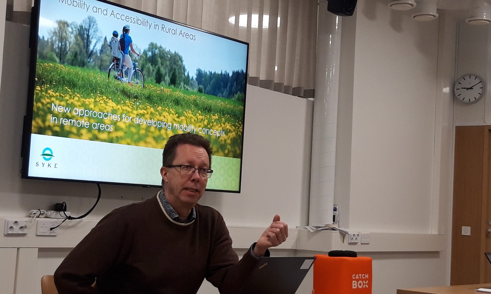
In the end of 2019, SYKE, the Finnish Environmental Institute, arranged a miniseminar on mobility research in urban, rural and touristic settings. The seminar addressed mobility research interrelations with spatial planning and governance, stakeholder engagement in spatial and transportation planning, sustainable mobility challenges in remote and touristic settings, and various methods for acquiring, processing and analysing mobility data.

The seminar was held in Helsinki and was part of the InterReg Baltic Sea-funded project MARA. The overall aim of the project is to address mobility and accessibility challenges in rural areas. Project activities and the perspectives and challenges of various mobility data were presented in the seminar by Kari Oinonen (SYKE), Age Poom (Digital Geography Lab, University of Helsinki & Mobility Lab, University of Tartu), Daniel Brandt and Tobias Heldt (both from CeTLeR, Dalarna University). SYKE researchers introduced their studies on GIS use in urban and rural planning (Ville Helminen), rural mobility, accessibility and travel related to second homes (Antti Rehunen), public participatory GIS (Elina Nyberg) and the architecture of spatial data infrastructure in SYKE (Kaisu Harju).

Continue reading “Mobility research in areas with seasonal population changes”