A new paper about identifying large ecological networks for regional planning with Zonation

A new paper out! Study “Identification of ecological networks for land-use planning with spatial conservation prioritization” by Joel Jalkanen, Tuuli Toivonen, and Atte Moilanen has just published a study in the Landscape Ecology journal. In the paper, we describe the work where we identified large well-connected ecological networks and ecological corridors for the Regional Council of Uusimaa, an authority responsible for regional planning in the Uusimaa province in Southern Finland. We used the Zonation spatial prioritization software in a novel way for identifying large well-connected structures, and the rarely-used corridor retention tool in Zonation for identifying ecological corridors. Zonation has been previously used to support regional zoning in Uusimaa, and dozens on layers of biodiversity data was available in the area.

It is quite straightforward to identify local high-priority areas (such as areas of high habitat quality) from Zonation results. In the case of Uusimaa, biodiversity is greatly scattered and concentrated in the top-20% priority areas. Ensuring the regional-level connectivity would be, indeed, highly important.

https://media.springernature.com/original/springer-static/image/art%3A10.1007%2Fs10980-019-00950-4/MediaObjects/10980_2019_950_Fig1_HTML.png

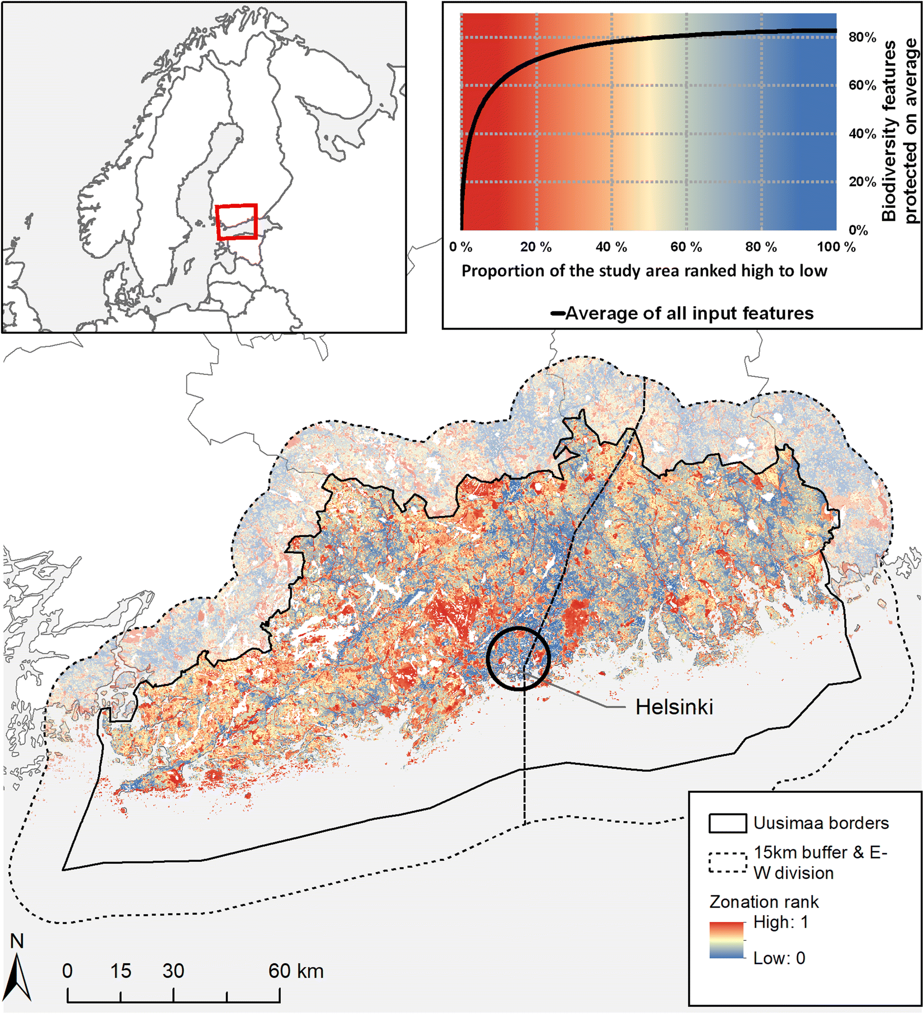
Uusimaa has a strong human influence, and high-priority areas are scattered. Picture from the article.

Continue reading “A new paper about identifying large ecological networks for regional planning with Zonation”

Mobility research in areas with seasonal population changes

In the end of 2019, SYKE, the Finnish Environmental Institute, arranged a miniseminar on mobility research in urban, rural and touristic settings. The seminar addressed mobility research interrelations with spatial planning and governance, stakeholder engagement in spatial and transportation planning, sustainable mobility challenges in remote and touristic settings, and various methods for acquiring, processing and analysing mobility data.

The seminar was held in Helsinki and was part of the InterReg Baltic Sea-funded project MARA. The overall aim of the project is to address mobility and accessibility challenges in rural areas. Project activities and the perspectives and challenges of various mobility data were presented in the seminar by Kari Oinonen (SYKE), Age Poom (Digital Geography Lab, University of Helsinki & Mobility Lab, University of Tartu), Daniel Brandt and Tobias Heldt (both from CeTLeR, Dalarna University). SYKE researchers introduced their studies on GIS use in urban and rural planning (Ville Helminen), rural mobility, accessibility and travel related to second homes (Antti Rehunen), public participatory GIS (Elina Nyberg) and the architecture of spatial data infrastructure in SYKE (Kaisu Harju).

Continue reading “Mobility research in areas with seasonal population changes”

Can we use Twitter data to estimate population distribution in Finland?

One of the main data processing steps before making use of novel data sources (e.g. Twitter data) for better understanding social processes and phenomena is the detection of users’ origins – be it at country, municipality or neighborhood level. This allows us to know whose Tweets in some geographical area (say, in a certain city or a neighborhood) we investigate. The most basic way is to distinguish locals from non-locals when examining mobility and activity locations of people. A more advanced analysis would require knowledge about origin countries in tourism studies and origin neighborhoods in segregation studies, for example.

This data processing step is also a prerequisite for cross-border mobility research – we need to know origins of people in order to categorize and analyze movements across country borders extracted from geotagged Tweets. Hence, it is the priority for our cross-border project. See, for example, the recent recent cross-border mobility analysis in the case of the Greater Region of Luxembourg from the MSc thesis by Samuli Massinen.

Continue reading “Can we use Twitter data to estimate population distribution in Finland?”

Done with the teaching! Overview of autumn 2019 courses

Autumn term is coming to an end!

Course teaching at the University of Helsinki is ending this week for the winter break. This autumn, researchers at the Digital Geography Lab have been working hard to share their knowledge and train the next generation. Innovative teaching approaches and teaching materials have also been developed further for the use of the University of Helsinki Geography programmes.

We congratulate and thank Vuokko Heikinheimo for leading and updating the hugely successful Automating GIS processes course together with Henrikki Tenkanen, Olle Järv for running and improving the Quantitative research techniques and analysis in human geography course, and Joel Jalkanen for putting lots of effort to re-inventing the Conservation Planning and Zonation course, together with Enrico Di Minin.

Continue reading “Done with the teaching! Overview of autumn 2019 courses”

Congratulations Claudia, Hertta and Elias for the City of Helsinki Master’s thesis award!

Yearly award for the best Master’s thesis have been again presented by the city of Helsinki on Monday the 9th of December 2019. We at the Digital Geography Lab would like to give special congrats to three awarded GIS wizards from the Department of Geography and Geosciences, Univerisity of Helsinki: Claudia Bergroth, Hertta Sydänlammi and Elias Willberg!

Bergroth Claudia (2019): Uncovering population dynamics using mobile phone data: the case of Helsinki Metropolitan Area.

The estimated hourly distribution of people on an average weekday in the Finnish Capital Region based on network-driven cellular mobile phone data. Read more about Claudia’s work in this blog post. 

Continue reading “Congratulations Claudia, Hertta and Elias for the City of Helsinki Master’s thesis award!”

Mapping the linguistic landscape of the Helsinki metropolitan area

The discipline of linguistics has a long-standing interest in researching language use in cities, because they bring together speakers of different languages from different backgrounds. Examples range from William Labov’s classic empirical research on the relation of social class and pronunciation of American English in New York City to modern theories of multilingualism in cities by Alastair Pennycook and Emi Otsuji. Regardless of the scope or focus, the consensus is that interactions between different languages and their speakers drive linguistic variation and change, whose effect is particularly strong in densely populated cities.

Within sociolinguistics, a subfield of linguistics broadly concerned with language in society, one emerging approach to the study of languages in cities concerns linguistic landscapes. The study of linguistic landscapes mainly focuses on the visibility and presence of languages in the built environment, performing qualitative analyses of languages in signs, advertisements, billboards and other media in built environments.

However, the physical spaces in which languages exist are being rapidly transformed due to technological development. These spaces increasingly extend into the digital realm due to the widespread use of positioning technology in smartphones and other mobile devices, which allow users to create and associate content with physical locations via geotagging. Social media platforms with geotagged content are a hallmark example of this development, which also offer new opportunities for linguistic research.

Continue reading “Mapping the linguistic landscape of the Helsinki metropolitan area”

Geotagged Twitter Data to Reveal Cross-Border Mobility of People

Overview of Samuli Massinen’s MSc thesis:

How can Big Data sources, such as georeferenced social media, be used in cross-border research? What kind of cross-border mobility patterns can be detected geographically over time? How can daily cross-border movements be separated from other movements? These were the main questions I was trying to find answers for in my Master’s thesis “Modeling Cross-Border Mobility Using Geotagged Twitter in the Greater Region of Luxembourg”.

The Greater Region of Luxembourg is the largest cross-border labor market in the European Union with the greatest number of cross-border workers in the area. European integration, the Schengen Area, and socio-economical divergences between neighboring countries have been the main factors facilitating human cross-border movements in the region and thus the emergence and expansion of the borderland community. Despite the freedom of movement, country borders still exist as well as their socio-economic differences. We witness the growing trend of people migrating to the other side of the country border while still working in Luxembourg. This actuates daily cross-border mobilities, which are not well known, to date. Thus, there is a distinct need to understand cross-border mobility dynamics in the region, especially border crossings on a daily basis.

Continue reading “Geotagged Twitter Data to Reveal Cross-Border Mobility of People”

How to infer complex dynamics from present-day landscape patterns? New publication provides a method

Present-day landscape patterns may provide information on past dynamics of the landscape. Spatial ecologists have taken advantage of this for a long time, for instance to infer colonization rates and dispersal distances of species from their present-day spatial distributions and occurrence patterns.

Inferring past dynamics from present-day patterns gets more complicated if multiple landscape elements have been simultaneously on the move. In this case, it may be helpful to reconstruct and simulate past landscape dynamics, to understand how different dynamic elements must have interacted in the past to produce the present-day pattern. Methods that reconstruct past interactions may help us to understand complex dynamics, without having to wait for years for the accumulation of time series data.

In our recent publication in the field of spatial ecology, we tested this by using data on a well-studied epiphytic lichen, Lobaria pulmonaria. For our study area, fire scar data existed on the timings and locations of forest fires for a 400-year time period. Given this known landscape disturbance history, we simulated and calibrated the dynamics of L. pulmonaria host trees and L. pulmonaria colonizations so that they resulted in patterns that match with present-day data (locations of L. pulmonaria occurrences and host trees). Our resulting colonization model of L. pulmonaria performed well against a model fitted to time series data.

We hope to inspire further studies on complex dynamics that utilize multiple types of information contained in present-day landscapes.

Fabritius et al. (2019): Estimation of metapopulation colonization rates from disturbance history and occurrence pattern data. Ecology 100: e2814.

How green are the streets of Helsinki?

Overview of Akseli Toikka’s MSc thesis: Mapping the green view of Helsinki through Google street view images

Interactive webmap for the Green View Index across Helsinki

Click to browse the interactive GVI map of Helsinki.

Urban vegetation has traditionally been mapped through traditional ways of remote sensing like laser scanning and aerial photography. However, it has been stated that the bird view examination of vegetation cannot fully represent the amount of green vegetation that the citizens observe on street level. Recent studies have raised human perspective methods like street view images and measuring of green view next to more traditional ways of mapping vegetation. Green view index (GVI) states the percentage of green vegetation in street view on certain location. The purpose of my thesis was to create a green view dataset of Helsinki city using Google street view (GSV) imagery and to reveal the differences between human perspective and aerial perspective in vegetation mapping.

Continue reading “How green are the streets of Helsinki?”

Environmental dialogues: how to plan for urban biodiversity?

Earlier this week, Henna Fabritius took part in the environmental dialogues -event  to discuss biodiversity-related modelling tools in urban greenery planning.

More information, and a recording of the event is available here (in Finnish):

Ympäristödialogeja: Miten suunnitella monimuotoista luontoa?

The event was organized by the Forum for Environmental Information (Ympäristötiedon foorumi in Finnish), which is a non-profit organization that aims at increasing interaction between the producers and users of environmental information in order to support national policy making in Finland, while keeping in mind the global significance of environmental problems.

Read also Henna’s blog about getting better at supporting urban biodiversity (in Finnish):
https://www.nessling.fi/ymparistodialogeja/mina-vaitan-luonnon-monimuotoisuutta-voitaisiin-tukea-kaupungeissa-nykyista-enemman/