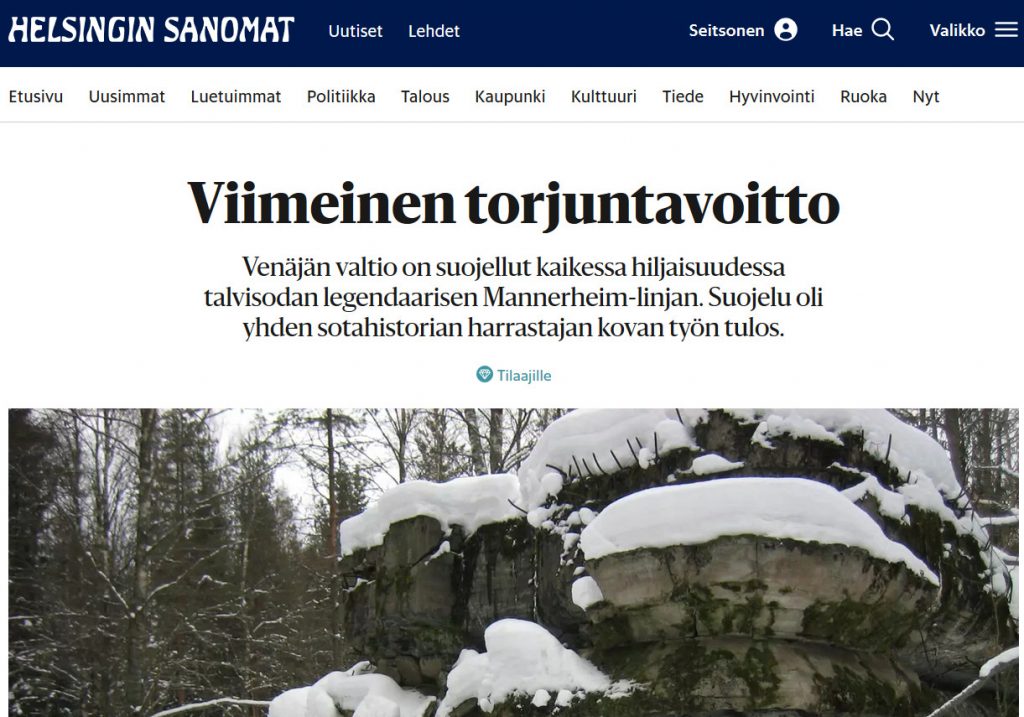
Helsingin Sanomat newspaper told in a recent article on January 23, how our Russian partner the Military Museum of the Karelian Isthmus in Vyborg and its Director Bair Irincheev managed to get the key sites situated in the Leningrad Oblast on the western Karelian Isthmus protected as cultural heritage! This is a very important step for the preservation of Finnish wartime heritage left on the Russian side of the border, and will hopefully be extended in the future to cover also the eastern parts of Mannerheim Line.
Helsingin sanomat article about protection of the Mannerheim Line / Helsingin Sanomien artikkeli Mannerheimlinjan suojelusta.
Helsingin Sanomat kertoi tuoreessa artikkelissa 23.1., kuinka venäläinen yhteistyökumppanimme Karjalan kannaksen sotamuseon ja sen johtaja Bair Irincheev ovat onnistuneet saamaan suojelupäätöksen Mannerheim-linjan Leningradin Oblastin puolella sijaitseville pääkohteille! Tämä on erittäin tärkeä edistysaskel suomalaisen sodanaikaisen kulttuuriperinnön suojelun kannalta Venäjän puolella ja tulee toivon mukaan kattamaan jatkossa myös Mannerheim-linjan itäisen osan esimerkiksi Taipaleen rintamaosalla.
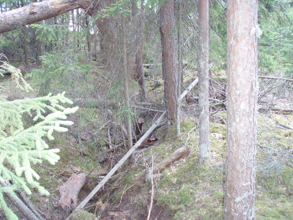
Our work on the archaeological and heritage potential of the Mannerheim Line continues, albeit slowly as we have not been able to access the research area this year at all. Instead we have concentrated on developing the public crowdsourcing interface for approaching the material remains remotely. This can then act as a basis for future fieldwork and for evaluating sites that are deemed of special importance by the public.
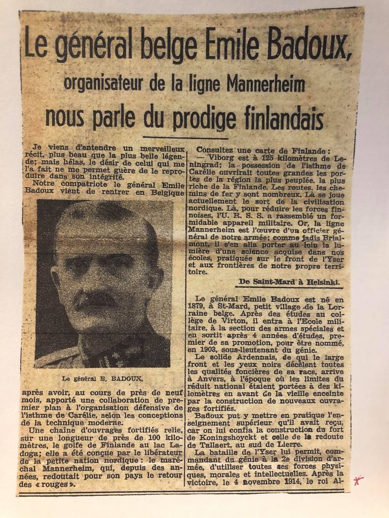
Newspaper article about General Badoux’s work on the Mannerheim Line (Photograph Birger Stichelbaut).
As soon as the Corona situation allows, our project will move to Eastern Karelian Isthmus to continue work in the Taipale region. This was planned for summer 2020, but was left half way when the border restrictions put it in halt.
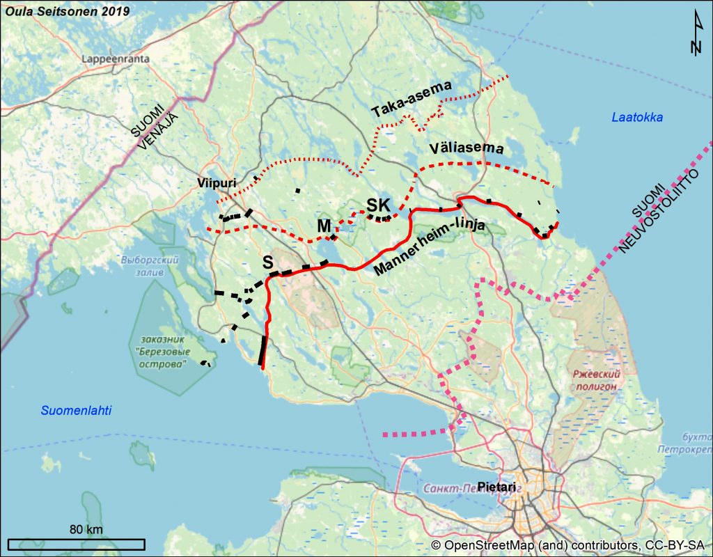
The sectors where the Belgian fortification specialists worked: S= Summa, M= Muolaa, SK= Salmenkaita.
Our Russian collaborator, the director of the Military Museum of the Karelian Isthmus in Vyborg Bair Irincheev has just delivered his survey report of the Mannerheim Line localities suggested for protection as cultural heritage. Bair has combined to the authorities a list of nearly 50 key sites situated in the Leningrad Oblast that might be protected as cultural heritage. He has been promoting the protection and preservation of Mannerheim Line for the future generations since 2006 and is extremely happy that it is finally taking steps forward!
Bair is also very active in organizing clearing and maintenance camps for volunteers at Mannerheim Line sites, and has done great work in marking out and facilitating access to bunkers for instance in the Summa area, where Red Army broke through the Mannerheim Line in early February 1940.
Venäläinen yhteistyökumppanimme, Viipurissa sijaitsevan Karjalan kannaksen sotamuseon johtaja Bair Irincheev on toimittanut inventointiraporttinsa kulttuuriperintönä suojeltavaksi ehdotetuista Mannerheim-linjan kohteista Leningradin oblastin alueella. Bair on koonnut listan lähes 50:stä merkittävästä kohteesta Mannerheim-linjalla kulttuuriperintöviranomaisille. Hän on promotoinut Mannerheim-linjan suojelua ja ylläpitoa tuleville sukupolville vuodesta 2006 ja on erittäin iloinen, että hanke vihdoin edistyy!
Bair on myös hyvin aktiivisesti järjestänyt talkoita, joissa vapaaehtoiset pitävät yllä Mannerheim-linjan kohteita ja raivaavat esimerkiksi bunkkereita kasvillisuudesta. Hän on tehnyt loistavaa työtä merkitsemällä esimerkiksi bunkkereita ja niiden raunioita maastoon ja edistäessään niiden saavuttamista, muun muassa Summan alueella, missä Puna-Armeija murtautui läpi Mannerheim-linjasta helmikuun alkupäivinä 1940.
Kantalinnoitteiden kartan ensimmäinen versio on nyt julkisesti tarkasteltavissa! Kommentteja ja parannusehdotuksia otetaan mielellään vastaan. Seuraavaksi käynnistyy tutkimuksen yleinen joukkoistava kartoitusvaihe, johon toivotaan suuren yleisön osallistumista.
First version of the permanent fortifications (Fi. kantalinnoitteet) map has now been made publicly available! Comments and suggestions are welcome. Next will be launched the public crowdmapping phase, in which we hope that the general public will take part.
Projektin ensimmäinen vaihe lähestyy loppuaan, ja Mannerheim-linjan kantalinnoitteista pääosa on saatu kartalle – kartta tulee pian näille sivuille kaikkien saataville!
Hankkeen ensimmäinen tutkimusvaihe keskittyi kantalinnoitteiden kartoittamiseen ja niiden säilyneisyyden arviointiin. Lisäksi joitakin kenttälinnoitteita on kartoitettu niitä tavattaessa, erityisesti Summan ja Taipaleen alueella.
Tutkimusten seuraavassa kenttätyövaiheessa loppusyksystä 2018 ja keväällä 2019 keskitytään enemmän kenttälinnoitteiden kartoittamiseen ja kunnon arviointiin. Yleisö voi ottaa osaa toisen vaiheen kenttätöiden suunnitteluun merkitsemällä näillä sivuilla pian aukeavaan karttaan mielestään kiinnostavia ja säilyttämisen arvoisia kohteita, sekä antamalla palautetta kartoitetuista kantalinnoitteista, esimerkiksi kohdetiedoista tai sijaintitarkkuudesta. Lisäksi olette tervetulleita merkitsemään lisätietoja, kuten historiallisia tietoja, kommentteina kartoitettujen kohteiden yhteyteen.
Yleisökartat tulevat pian sivuille!
—
First phase of the project is nearing its end, and most of the main permanent fortifications of Mannerheim Line have been mapped – map of this work will appear soon on these pages!
First phase concentrated on mapping and evaluating the preservation of permanent fortifications (Fi. kantalinnoitteet). On top of this, some field fortifications, such as trenches and log-built dugouts, have been marked on the maps, especially in the Summa and Taipale sectors.
Second phase of the field research in late fall 2018 and spring 2019 will concentrate more on mapping and evaluating the preservation of field fortifications. Public can take part in the planning of the second phase by marking interesting sites on the crowdsourcing map that will soon appear on these pages. You are also welcome to give feedback on the mapped permanent fortifications, for instance, about the site information and locations. You can also mark extra information, such as historical information, as comments to the mapped sites.
Conflict archaeological research project Archaeology of the Mannerheim Line will be mapping the heritage value of this Finnish Second World War defensive line in Karelian Isthmus, nowadays Russia, in 2018-2019. Project is directed by Dr. Oula Seitsonen (Archaeology, University of Helsinki/University of Oulu). Project will include both archeological field research in Russia and public crowdsourcing which will map public opinions of especially important structures and sites along the Mannerheim Line. Crowdsourcing element will open soon on this page.
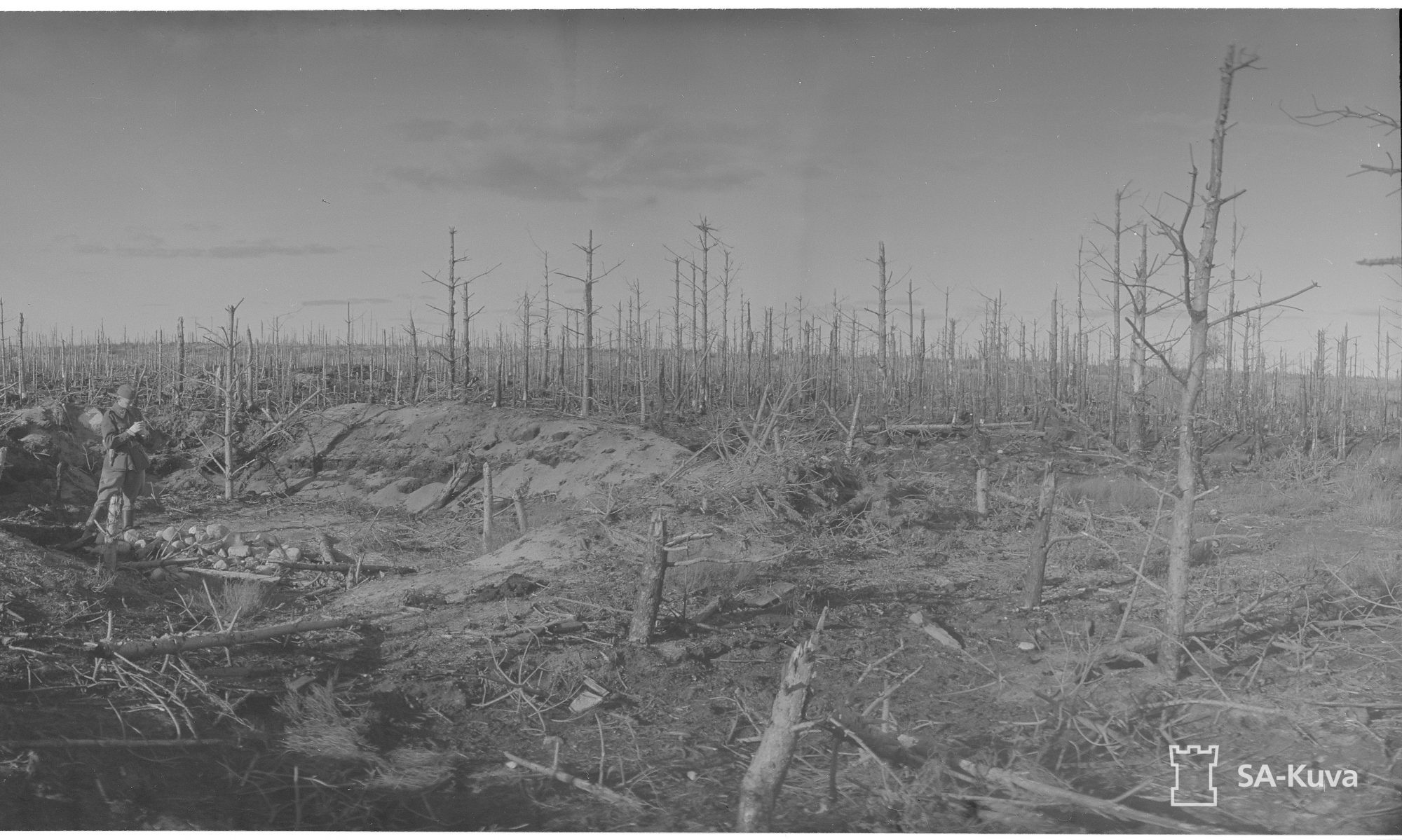
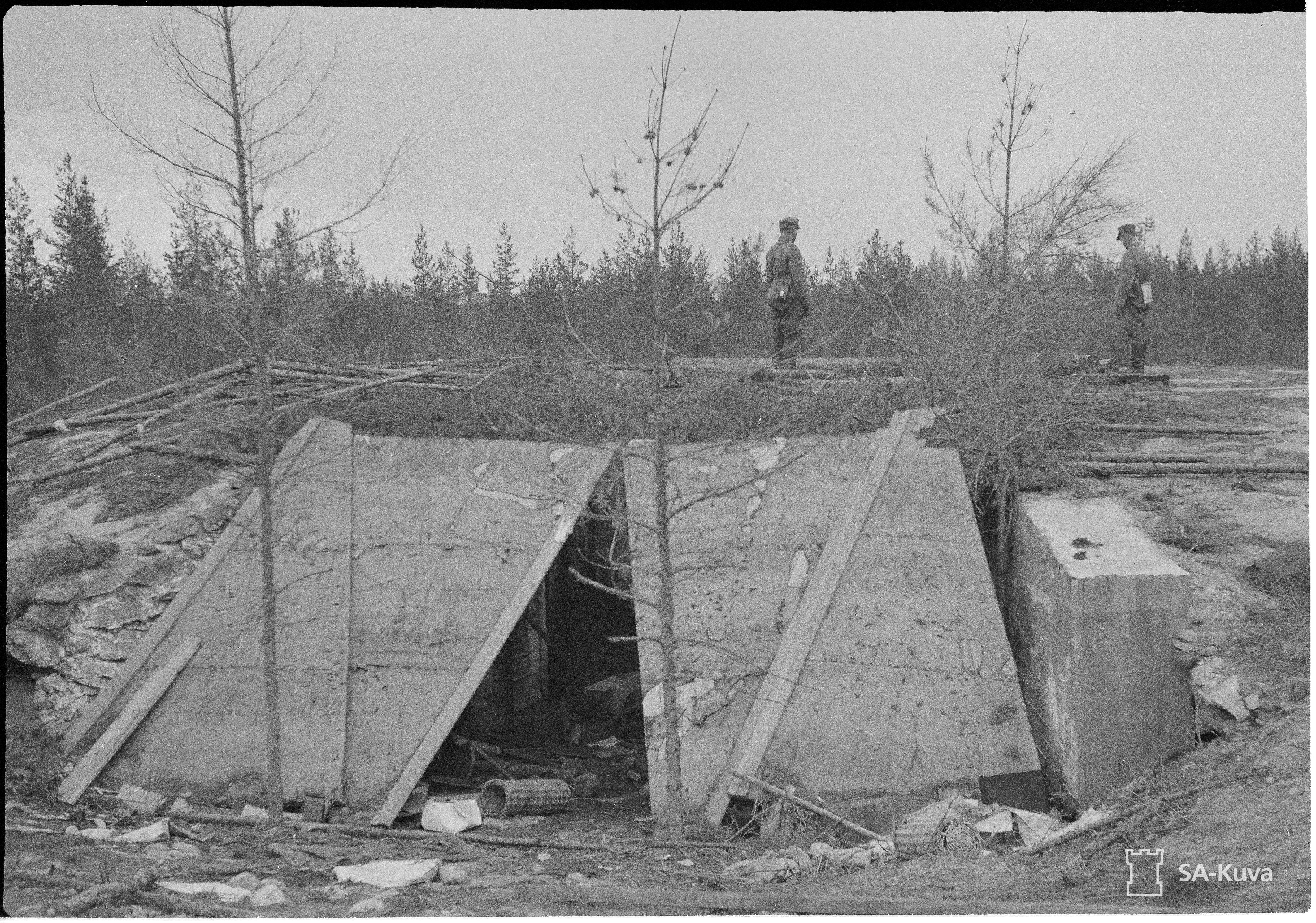
Bunker of Kaarnajoki fortress / Kaarnaojan linnakkeen kasematti (SA-kuva).
Konfliktiarkeologinen tutkimusprojekti Mannerheim-linjan arkeologiaa kartoittaa suomalaisten toisen maailmansodan aikaisten puolustusvarustusten kulttuuriperintöarvoa Karjalankannaksella 2018-2019. Hanketta vetää arkeologi Oula Seitsonen (Helsingin yliopisto/Oulun yliopisto). Projektiin sisältyy sekä arkeologista kenttätutkimusta Venäjällä että suurelle yleisölle suunnattu osallistava karttahanke, jossa kaikki halukkaat voivat merkitä mielestään kiinnostavia kohteita kartalle, kommentoida muiden merkitsemiä kohteita sekä projektissa tähän mennessä kartoitettuja kohteita. Yleisökartta aukeaa pian näillä sivuilla.