About Deleted User

Special user account.

How long does it take to park a private car in Helsinki Capital Region? – A map based survey

The parking survey is available in English and in Finnish.

Read in Finnish

How long does it take to park a private car in Helsinki Capital Region? Is there variation in parking times in different districts of the Capital Region? How can we explain the hypothetical variation?

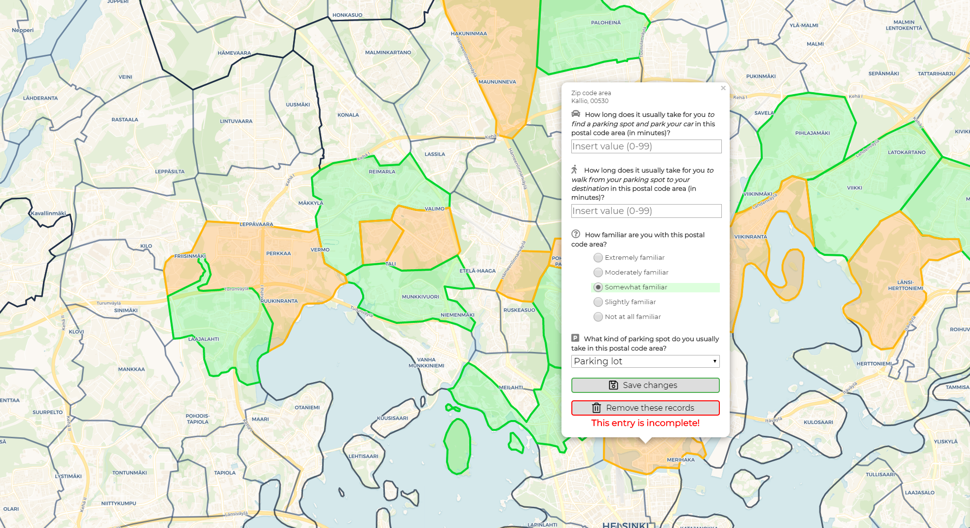
We are now researching how long does it take for a private car to find a parking spot, park and walk to one’s final destination in different areas of Helsinki Capital Region using a map based survey. In the survey linked below the user chooses postal code areas where they remember having parked in the last two years. For each postal code area user is asked to fill a short form how their parking experience usually is in that area. The survey is created in such a way that data can be sent from as many postal code areas as the user wants – all in one session.

Please find the map based web application survey here. We ask you to answer to the survey latest at 30th June 2019. The survey starts up by default in English. If you wish to fill out the survey in Finnish, you can change the language by clicking the EN/FI button located in the upper left corner of the screen.

About the research

This survey research is a part of the Master’s thesis of Sampo Vesanen. The work is connected to the Helsinki Region Travel Time Matrix, a tool created by Digital Geography Lab which represents travel time distances between statistical grid cells in Helsinki Region by public transport, walking and bicycling. The values in the travel time matrix are calculated using the door-to-door approach. For private cars this means that searching for parking, the parking proper and walking to one’s destination is a part of the travel time. Up until now the time it takes to carry out this process has been a singular estimation deployed to the entire Helsinki Capital Region. This does not represent reality well enough.

The data collected from this survey are used to answer the following questions: what is the variation in parking times between postal code areas in Helsinki Capital Region, what could cause the variation and what is the significance of the parking time in the context of the total travel time of a private car in Helsinki Capital Region. The finalised results of the Master’s thesis will be used to supplement the private car parking process data in the Helsinki Region Travel Time Matrix.

Filling the survey

In the survey the user is asked to estimate how their parking experience usually is in each postal code area. Please answer to each question using your best judgement and answer to each postal code area only once. We seek responses not older than two years because the urban structure of Helsinki Capital Region experiences constant change and possibilities for private car parking change with it. If you require additional information about the questions in the survey, please refer to the information dialog window in the survey. This window will appear on the screen of your device at survey start-up.

You can use a desktop computer, a laptop or a mobile device to fill out the survey. It requires 1-10 minutes of your time. On desktop or laptop it is important you use the latest browser software, recommendations being Chrome or Firefox. On mobile devices it is recommended to use a device that runs Android with Chrome being the browser software. If you wish to fill out the survey using your mobile device (especially if using an Apple device), please read the mobile usage instructions in the information dialog window.

Usage of gathered data

The data gathered in this survey do not reveal any personal information about respondents because of the general scope of the questions used. The web application running the survey will save your IP address for tracking user activity. In the analysis phase of the thesis all collected IP addresses will be altered into random and anonymous string of characters and all the IP addresses will be deleted. The survey web application uses cookies to save user preferences. If you do not delete the cookies manually, they will expire 90 days from their creation.

Further information

In any inquiries regarding the survey or the research, please contact Sampo by email: sampo.vesanen(at)helsinki.fi.

The 24-h population dynamics of the Finnish Capital Region uncovered!

Figure 1. The estimated hourly distribution of people on an average weekday in the Finnish Capital Region based on network-driven cellular mobile phone data.

Understanding where people are and when – What is the pulse of the city? – is of high importance in urban planning, management and governance. Accurate information of the dynamic population distribution is crucial for example for land use and transport planning, disaster and conflict preparedness, evacuation purposes and for mitigating the spreading of diseases.

So far, our understanding of the whereabouts of people in time and space is scarce and predominantly based on static census data – people are expected to stay at home, although people rarely stay there the entire day. For instance, in (place-based) spatial accessibility research the use of home locations are considered as a proxy for origins of people despite the widely acknowledged criticism of the approach.

Fortunately, novel temporally sensitive spatial data sources, such as mobile phones, geotagged social media posts and smart cards can provide new solutions to uncovering the actual whereabouts of population in space and time.

In my thesis, I set out to uncover the spatio-temporal population dynamics in the Finnish Capital Region using mobile phone data. The data was provided by one of the main mobile network operators in Finland. Network-driven mobile phone data was interpolated to statistical 250 m x 250 m grid squares to estimate the hourly population distribution on a typical weekday (Monday-Thursday).

To refine the estimated population distribution derived from mobile phone data, I applied and adapted an advanced interpolation method developed by the Digital Geography Lab that uses ancillary information of land use, floor area and use type of buildings, and a time use survey to improve the accuracy of the results. The results were then validated against official census data during night-time (2 AM – 5 AM), which showed that the advanced interpolation method significantly improves the population distribution derived from mobile phone data.

Figure 2. The estimated hourly weekday distribution of people in six individual 250 m x 250 m grid cells. The graphs show the share of present population in the given grid square of the hourly total of all grid cells in HMA.

The results highlight, that network-driven mobile phone data can be used to catch the daily pulse of the Finnish Capital Region. The morning hours show a clear transition in the whereabouts of people from residential areas to work place areas. The afternoon pattern is however not as straightforward – people may stop by a store or undertake leisurely activities on their way back home. As a matter of fact, population concentrations in the shopping malls and recreational areas are highest in the evening according to the results. Also, the polycentricity of the study area as well as the incoming and outgoing population flows along the major roads in the morning and afternoon can be distinguished from the data.

The typical home-work-home rhythm can clearly be seen for instance in the Aalto University campus area in Otaniemi. During day time, the concentration of population is highest in the campus area, but as the evening draws closer, the concentration shifts to the Teekkarikylä residential area at the end of the cape.

So, what’s next? I will implement the dynamic population distribution to examine the 24-h accessibility to grocery stores and introduce the first fully dynamic accessibility model in the study area using an approach developed by the Digital Geography Lab. Stay tuned!

Claudia Bergroth,

Geoinformatics MSc. Student

New course starting: Analysing accessibility and mobility using novel data sources

We are organizing a special course on accessibility and mobility issues, staring on November 1st. The course is entitled: “Analysing accessibility and mobility using novel data sources” and it will familiarize the students with current theory of accessibility and mobility research, as well as practical tools and data developed by our group. Looking forward to meeting the students and hearing their thoughts on these topics!

Henrikki and Maria in NECTAR-workshop in Warsaw

We participated in a NECTAR worshop (Network on European Communications and Transport Activities Research) in Warsaw between 20.-21.10.2016. The workshop was entitled “Transport Infrastructures for better Accessibility, Equity and Territorial Cohesion” and there were nearly 30 interesting and inspiring accessibility-related presentations from all over Europe. Henrikki presented our recent paper on grocery store accessibility (published in International Journal of Health Geographics) and Maria presented our ongoing work on dynamic accessibility modelling.