Joelin lektio 27.11.2020

Alueiden suojeluarvottaminen kaupunki- ja maakuntatason maankäytön suunnittelun tueksi

FM Joel Jalkasen Lectio praecursoria -puhe 27.11.2020
Public defence of Joel Jalkanen's PhD thesis
The opponent (Professor Niina Käyhkö), the custos (Professor Tuuli Toivonen) and the doctoral candidate (MSc Joel Jalkanen) in Athena hall 107 on 27th of November 2020

Arvoisa kustos, arvoisa vastaväittäjä, hyvät kuulijat

Me ihmiset aiheutamme toimillamme paraikaa massasukupuuttoa, joka uhkaa suurta osaa maailman elämästä. Tällä hetkellä selkeästi suurin uhka maapallon lajistolle on se, että ihmiskuntamme tuhoaa elinympäristöjä omien tarpeidensa alta.

Eri lähteistä toistuva viesti on selkeä ja kiistaton: tapamme käyttää maata on kestämätön.

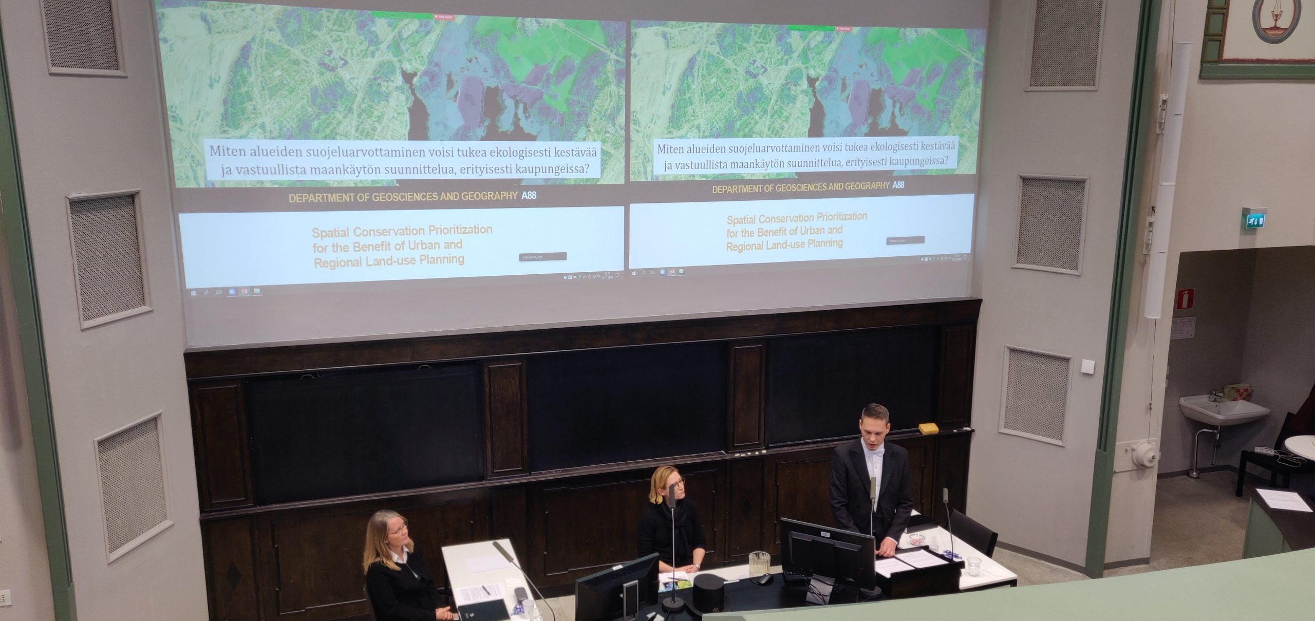
Kuvaamani ongelma kilpistyy hyvin oheiseen kuvaan. Luonto esiintyy paikassa, ja samoin ihmisten intressit esimerkiksi ruuantuotantoon tai kaupunkien rakentamiseen kohdistuvat usein paikkaan. Siellä, missä toinen haluaisi perustaa luonnon puolesta suojelualueen, näkee toinen hyvän paikan uudelle asuinalueelle.

Tätä ristiriitaa ratkotaan maankäytön suunnittelulla. Siinä sovitellaan erilaisia paikkoihin kohdistuvia tarpeita ja intressejä ja tarkastellaan, miten niitä voidaan saavuttaa rajallisen fyysisen tilan puitteissa.

Continue reading “Joelin lektio 27.11.2020”

New paper out: Spatial prioritization for accessibility of urban parks

In our recent paper published in Applied Geography, we combine travel time modeling with spatial conservation prioritization to identify green areas that best serve the recreational use. We consider equitable access between urban dwellers, the need for various types of parks, and the use of various transport modes. The paper puts together approaches from conservation planning and accessibility research to support land-use planning decisions.

Green areas are important for urban residents. But how to prioritize between them? (Image by Angelo Giordano from Pixabay.com)


Spatial (conservation) prioritization is a way to identify “less” to “more important” places for conservation or other land uses based on multiple criteria. The outputs of the prioritization can be useful for locating optimal places for protection, for instance, or in our case, recreation. One of the major principles in spatial prioritization is complementarity, i.e. the attempt to secure the existence of all species and habitats (or, whatever is used as input data) in the prioritization process.

A spatial prioritization software Zonation, developed at the University of Helsinki, works as follows: It first takes the full study area under examination and checks how widely-distributed different input features are (be it multiple species, for example). It then takes away a small bit of the area; namely, the bit that corresponds the least to the total biodiversity in the area. Such areas would only harbor few species that are generally widely distributed. Zonation repeats these steps, checking the distributions and removing the least valuable areas, until the entire target area is completely ranked. The prioritization process is based on a ‘Robin Hood algorithm’ that always tries to take away from those species that have the most available areas at the corresponding iteration. This principle of complementarity results in high coverage of protected features compared to more traditional hotspot approach.

Continue reading “New paper out: Spatial prioritization for accessibility of urban parks”

Reflections on the 8th Nordic-Baltic Migration Conference

The second panel ”New Challenges in Cross-Border Mobility, Nordic-Baltic Region” in the Nordic-Baltic Migration Conference in Tallinn, Estonia

Olle Järv from the Digital Geography Lab attended as an expert panellist in the Nordic-Baltic Migration Conference “Cross-border Mobility in the Nordic-Baltic Region organized by the Nordic Council of Ministers’ Office in Tallinn, Estonia on September 18, 2020. Olle participated in the second panel ”New Challenges in Cross-Border Mobility, Nordic-Baltic Region” together with Uffe Palludan (Palludan Fremtidsforskning), Jonas Wendel (Nordic Council of Ministers’), Rolle Alho (Uni Helsinki), and Saara Pellander as a moderator (Migration Institute of Finland). In the panel, Olle briefly introduced his BORDERSPACE research project on cross-border mobility and transnational people, and how these research topics benefit from novel data sources such as social media and mobile phone data.

Continue reading “Reflections on the 8th Nordic-Baltic Migration Conference”

Green Paths -reittiopas edistää terveellistä ja aktiivista matkustamista

Age Poom, Joose Helle, Tuuli Toivonen

Uusi Green Paths -reittiopas auttaa valitsemaan hiljaisemman ja ilmanlaadultaan parhaan pyöräily- ja kävelyreitin.

Pääkaupunkiseudulla toimivan reittityökalun suositukset perustuvat reaaliaikaiseen tietoon ilmanlaadusta sekä kaupungilla tehtyihin melutasomittauksiin. Sovelluksen avulla liikkuja välttää vilkkaasti liikennöidyt kadut, mutta pääsee silti perille kohtuullisessa ajassa.

Helsingin yliopiston Digital Geography Lab -tutkimusryhmä on kehittänyt Green Paths -reittityökalun auttamaan jalankulkijoita ja pyöräilijöitä löytämään miellyttävimmät reitit. Nyt julkistettu sovellus on prototyyppi, joka toimii Helsingin, Espoon, Vantaan ja Kauniaisten alueella.  Näissä kunnissa on saatavilla sovelluksen tarvitsemaa dataa.

Yleensä reittioppaat tarjoavat nopeimpia tai lyhimpiä reittejä, mutta miellyttävyyttä ja terveellisyyttä ei huomioida. Ohjaamalla pyöräilijät ja kävelijät miellyttävämpään matkaympäristöön reittiopas pyrkii edistämään kaupunkiliikkujien terveyttä ja hyvinvointia. Tutkimusryhmämme toivoo reittioppaan edistävän myös ilmastollisesti vastuullista ja kestävää kaupunkiliikennettä.

Continue reading “Green Paths -reittiopas edistää terveellistä ja aktiivista matkustamista”

Green Paths routing tool encourages healthy and active travelling

Authors: Age Poom, Joose Helle, Tuuli Toivonen

The new Green Paths routing tool helps pedestrians and cyclists to choose urban commuting routes with less air and noise pollution. The tool is a proof of concept of exposure-optimised routing. It functions in the Helsinki capital region where the necessary environmental data is available.

This novel routing tool suggests a set of routes to the user-defined destination that are less polluted than the shortest, often busy main road. This is different from the traditional routing concept that considers only distance or travel time for route choices.

The users of the Green Paths routing tool can follow their own preferences in making the final route choice that is quieter, has fresher air and feels more pleasant. As such, the user becomes an active decision-maker, empowered to choose the most appealing route with only a modest increase in travel time. The new Green Paths routing tool indeed aims to improve travel satisfaction. A pleasant travel experience makes commuters more likely to walk or cycle regularly. In this way, commuters using the Green Paths tool contribute to a more sustainable city with cleaner air.

Continue reading “Green Paths routing tool encourages healthy and active travelling”

NoRSA 2019 Keynote: Tuuli Toivonen

We will also start sharing our presentations in the Digital Geography Lab blog!

To start out, we will share Tuuli’s Keynote presentation at NoRSA 2019 Conference Seinäjoki, Finland, 19th June 2019 that summarizes much of our ongoing work related to socio-spatial interactions and Big Data:


COVID-19 is spatial: Ensuring that mobile Big Data is used for social good

Authors: Age Poom, Olle Järv, Matthew Zook and Tuuli Toivonen

We have just published our commentary regarding human mobility, mobile Big Data and the responses to COVID-19 pandemic in the Big Data & Society journal (see also the journal’s blog).

This commentary was motivated by our previous experience with mobile Big Data and recent work on changed human mobility derived from mobile phone data during the COVID-19 outbreak in Finland (e.g. Järv et al. 2020a; Järv etal. 2020b). It also draws from the knowledge and experiences of our peers around the globe.

In short, the mobility restrictions related to COVID-19 pandemic have resulted in the biggest disruption to individual mobilities in modern times. The crisis is clearly spatial in nature, and examining the geographical aspect is important in understanding the broad implications of the pandemic. We can benefit from the avalanche of mobile Big Data that makes it possible to study the spatial effects of the crisis with spatiotemporal detail at the national and global scales. Yet, the current crisis also highlights serious limitations in the readiness to take the advantage of mobile Big Data for social good, at large, regarding technological, administrative and legislative aspects.

Continue reading “COVID-19 is spatial: Ensuring that mobile Big Data is used for social good”

Quiet paths for daily travel: developing online navigation and exposure assessment tool

Overview of Joose Helle’s MSc thesis

Exposure to noise pollution can cause various adverse health effects such as increased blood pressure and stress levels. Noise exposure has traditionally been assessed in terms of home location, as required by national and international policies. However, a substantial share of individuals’ total daily noise exposure is likely to happen while they are on the move. This evidently also affects the healthiness of active travel modes, walking or cycling, by reducing or even outweighing positive health effects of physical activity. Thus, there is a clear need for advancing exposure assessment beyond residential location to gain a true understanding of exposure profiles and their potential effects on health and well-being.

Journey-time exposure assessment can study spatially dynamic exposure to pollutants as people move through the urban environment. Furthermore, least-cost routing can be applied to find healthier paths with lower exposure levels to pollutants. This novel research field has a potential to support urban sustainability and equitability through increasing awareness of the qualities of travel environments, assessing population exposure, supporting individual mobility choices as well as planning healthier travel infrastructure throughout the urban fabric.

These tasks are not trivial. How to assess dynamic exposure to noise pollution? How to find routes with less noise than on the shortest route? How to develop a mobile navigation application for exposure-based route planning? These were the key questions I addressed in my master’s thesis: Quiet paths for people: developing routing analysis and Web GIS application, defended in May 2020 at the University of Helsinki.

Continue reading “Quiet paths for daily travel: developing online navigation and exposure assessment tool”

COVID-19 causes a threat to protected areas in the Global South – evidence from Madagascar

Authors: Johanna Eklund, Ari-Pekka Jokinen, and Tuuli Toivonen

Introduction

The coronavirus pandemic will have long lasting impacts on the conservation of biodiversity and protected areas. In many Nordic countries, people have been visiting green areas, protected areas included, more than ever. In the Global South however, the situation is almost the opposite, putting conservation at risk. In many developing countries, nature-based tourism has been important for financing biodiversity conservation. Tourism to protected areas has, however, ceased drastically during the global confinement strategies. The consequences of vanishing tourism are very visible for example in Madagascar, one of the world’s biodiversity hotspots, with the highest number of threatened species globally. While being rich in biodiversity, Madagascar is economically among the poorest nations in the world. Madagascar currently has protected 7.5 % of its terrestrial land area, but this protection relies on funding from abroad. Previous research (Eklund et al. 2016 & Eklund et al. 2019) have shown that the protected areas have the capacity to curb deforestation, but funding is needed for the maintenance of conservation actions.

In Madagascar, tourism contribute to approximately 30 % of the annual income of the protected area agency Madagascar National Parks (MNP). MNP is managing some of the most visited national parks in the country. Due to the pandemic there have been concerns raised that the loss of tourism revenue could make the protected areas more vulnerable to illegal encroachment, such as poaching and deforestation. Both Mongabay and National Geographic have reported about these concerns recently. So far the concerns have been based on expert opinions and anecdotal evidence. In this writing, we provide evidence that the protected areas in Madagascar are experiencing rapid increases in human induced fires during the corona crisis.

Continue reading “COVID-19 causes a threat to protected areas in the Global South – evidence from Madagascar”

A new paper on understanding the use of urban green spaces from user-generated data

Parks and other green spaces are an important part of sustainable, healthy and socially equal urban environment. Urban planning and green space management benefit from information about green space use and values, but such data are often scarce and laborious to collect. Temporally dynamic geographic information generated by users of different mobile devices and social media platforms are a promising source of data for studying green spaces.

Social media data, sports tracking data, mobile network data and PPGIS data from green spaces
Examples of social media data, sports tracking data, mobile phone data and PPGIS data from green spaces in Helsinki, Finland.

In a recent article published in the Landscape and Urban Planning journal we compare the ability of different user-generated data sets to provide information on where, when and how people use and value urban green spaces. We compare four types of data: social media, sports tracking, mobile phone operator and public participation geographic information systems (PPGIS) data in a case study from Helsinki, Finland, and ask: 1) where the spatial hot-spots of green space use are, 2) when people use green spaces, 3) what activities are present in green spaces and 4) who are using green spaces based on available sample data sets.

Continue reading “A new paper on understanding the use of urban green spaces from user-generated data”